Forecast of the new low pressure area in the East Sea

Thanh Hà |

The low pressure in the East Sea is forecast to have a wide area of influence, towards Hainan Island (China) and Vietnam.

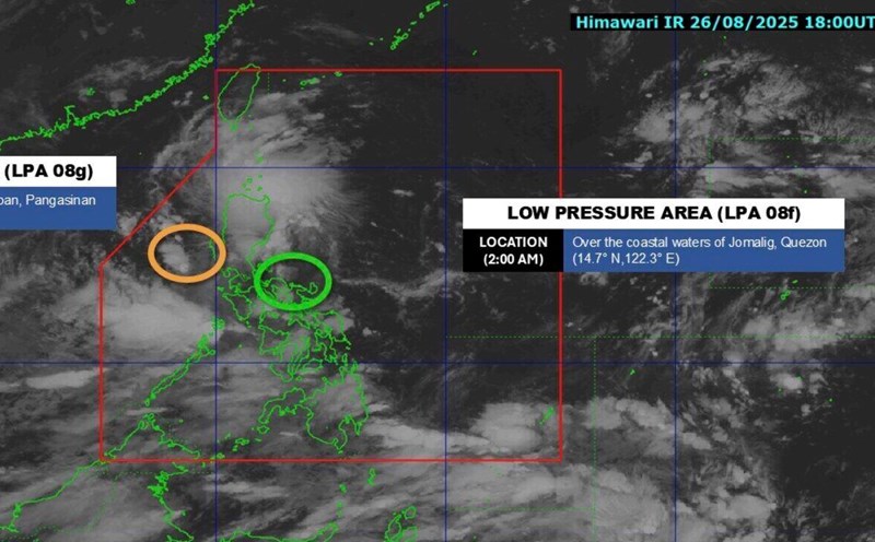
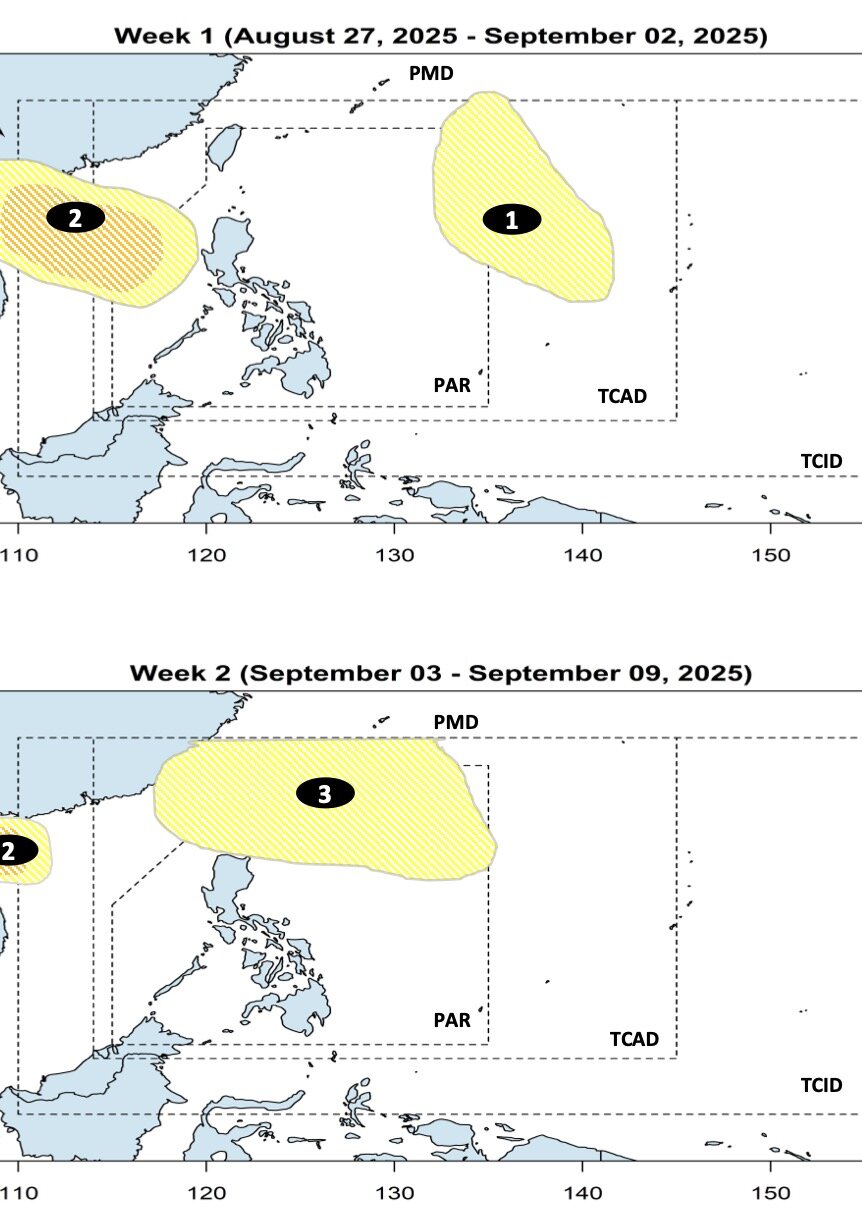
The latest storm and low pressure forecast on August 27 from the Philippine Atmospheric, Geophysical and Astronomical Services Administration (PAGASA) said that it is expected that during the week from August 27 to September 2, there will be 2 low pressure areas appearing in the PAGASA PMD forecast area. These two depressions include one low pressure near the East Sea and one low pressure over the East Sea.

The low pressure near the East Sea is forecast to appear first in PAGASA's TCAD forecast area. This low pressure is unlikely to strengthen into a storm and is likely to enter the northeastern area of the Philippine Forecast Area (PAR).

The low pressure forecast in the East Sea is also expected to form during the forecast period, in the eastern area of the East Sea. This low pressure is likely to strengthen into a storm or tropical depression higher than the low pressure near the East Sea.

The low pressure in the East Sea is forecast to have a wide area of influence and continue to move westward during the week from September 3 to September 9. This low pressure is forecast to head towards Hainan Island (China) and Vietnam.

During this forecast period, a third low pressure is expected to form in the northern part of the Philippine Sea, with little chance of strengthening into a storm.

Philippine forecasters say the low pressure area that will form during the week of September 3 to September 9 will head towards Taiwan (China).

Du bao ap thap quanh Bien Dong trong nhung ngay cuoi thang 8, dau thang 9. Anh: PAGASA
Low pressure forecast around the East Sea in late August and early September. Photo: PAGASA

According to the latest forecast from Philippine weather forecasters, there is a possibility of 2-4 low pressure areas forming or entering the Philippine forecast area in September. The next typhoon names for the 2025 typhoon season in the Philippines include: Jacinto, Kiko, Lannie and Mirasol.

According to PAGASA expert Ryan Diocampo, based on climate data, storms or tropical depressions in September usually have 4 common directions.

Some systems are moving northeast of the PAR toward Japan or South Korea. These systems do not make landfall in the Philippines and are less likely to affect the southwest monsoon (habagat).

The second path of the storm, the September tropical depression, is the northwest ring of the PAR, towards Taiwan (China), thereby enhancing the activity of the southwest monsoon.

Third, storms and tropical depressions make landfall north or northernmost of Luzon, Philippines before moving towards Hong Kong (China) or mainland China.

Finally, some storms or tropical depressions make landfall south of Luzon before continuing to enter the East Sea, heading towards Vietnam.

Thanh Hà
RELATED NEWS

Forecast of an unusual period of the 2025 storm season after storm Fernand

|

Hurricane Fernand is forecast to weaken and open an unusual phase of the 2025 Atlantic hurricane season.

New low pressure near the East Sea has not dissipated yet

|

The low pressure near the East Sea that formed a few days ago continues to operate while a low pressure in the East Sea has just formed on the morning of August 27.

Typhoon Juliette approaches maximum, forecast to be strongest in the next few hours

|

Hurricane Juliette is expected to strengthen into a hurricane, peaking on August 26.

Seminar: Using energy economically and efficiently - Sustainable solutions for businesses and people

|

In the context of rising electricity and fuel prices and increasing pressure for green transformation, saving energy is no longer a call but has become an urgent requirement to maintain sustainable growth and protect the environment.

Doan Ngoc Tan has a broken rib, absent from the Vietnam national team

|

Midfielder Doan Ngoc Tan could not gather with the Vietnam national team after a very serious injury in the match between Ha Tinh and Thanh Hoa.

The entire Vung Ang - Bung expressway will open to traffic from 8:00 a.m. on August 28

|

Quang Tri - From 8:00 a.m. on August 28, the Vung Ang - Bung expressway, over 55km long, was officially put into operation on the entire route.

Ms. Paetongtarn determined to return to the Prime Minister's chair on the day the court issued the verdict

|

Ms. Paetongtarn was optimistic about returning to the position of Thai Prime Minister, expressing her determination to return to work this weekend.

Nguyen Thuy Linh excellently entered the third round of the 2025 badminton World Cup

|

Nguyen Thuy Linh has won a ticket to the third round of the women's singles event of the 2025 Badminton World Cup held in France.

Forecast of an unusual period of the 2025 storm season after storm Fernand

Thanh Hà |

Hurricane Fernand is forecast to weaken and open an unusual phase of the 2025 Atlantic hurricane season.

New low pressure near the East Sea has not dissipated yet

Thanh Hà |

The low pressure near the East Sea that formed a few days ago continues to operate while a low pressure in the East Sea has just formed on the morning of August 27.

Typhoon Juliette approaches maximum, forecast to be strongest in the next few hours

Thanh Hà |

Hurricane Juliette is expected to strengthen into a hurricane, peaking on August 26.