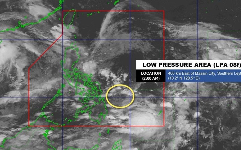
The Philippine Atmospheric, Geophysical and Astronomical Services Administration (PAGASA) said that at 2:00 a.m. on August 26, the center of the low pressure was at 13.8 degrees North latitude, 122.8 degrees East longitude, in the coastal waters of paracale, Camarines Norte. The low pressure is likely to strengthen into a tropical depression in the next 24 hours.
The low pressure and southwest monsoon will bring rain and thunderstorms across the country on August 26.
Weather forecaster Obetrina Badrina said that if the depression does indeed become a tropical cyclone, it could only form during the day and eventually dissipate as it moves west.
The low pressure is forecast to bring heavy rain to the areas of Isabela, Aurora, Bulacan, Quezon, Laguna, Rizal, Camarines Norte, Camarines Sur, Albay, Sorsogon, Catanduanes and Masbate.
Floods can occur mainly in urbanized areas, low-lying areas or near rivers. Earthquakes can occur in vulnerable areas.
The Manila urban area, Cagayan Valley, Cordillera Administrative Region, Central Luzon, the rest of the Bicol Region and Eastern Visayas will experience cloudy skies with scattered showers and thunderstorms due to low pressure.
Meanwhile, Mimaropa, the Zamboanga Peninsula, BarMM, Northern Mindanao, Caraga and the rest of Visayas will also experience cloudy skies with scattered showers and thunderstorms due to Typhoon Habagat.
The remaining areas of the country will have cloudy to cloudy skies with scattered showers or thunderstorms due to local thunderstorms.
Meanwhile, according to the US Joint Typhoon Warning Center (JTWC), the low pressure system Invest 93W in the Philippines is gradually strengthening, although the circulation is still wide and the wind is light. The low pressure is unlikely to yet become a typhoon before sweeping across Luzon Island on the morning of August 26.
However, after reaching the South China Sea and merging with the monsoon disturbances in West Mindoro on August 27, the depression has favorable conditions to strengthen. The low pressure is forecast to develop into a tropical depression from August 28 or 29, moving west towards Vietnam. The JTWC assessed the possibility of the low pressure developing in the next 7 days at 70%.
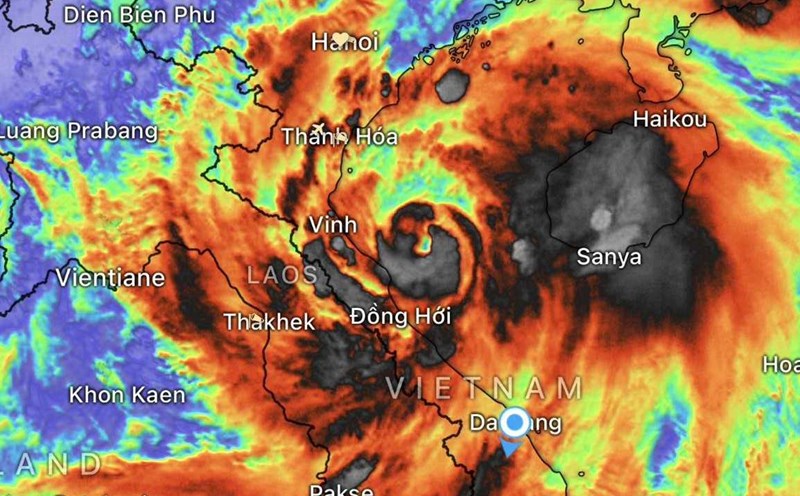
According to the Vietnam National Center for Hydro-Meteorological Forecasting, in the early morning of August 26, storm No. 5 weakened into a tropical depression in the Central Laos area.
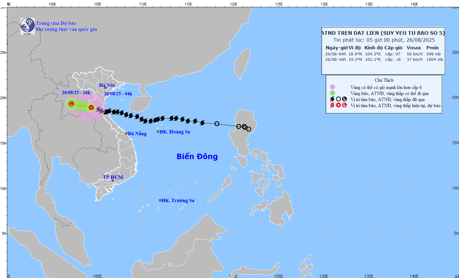
At 4:00 a.m. on August 26, the center of the storm was at 18.9 degrees North latitude, 104.5 degrees East longitude (China).
The strongest wind is level 7 (50-61km/h), gusting to level 9; moving in the West Northwest direction, 15-20km/h.
Previously, many coastal stations in Nghe An - Ha Tinh recorded strong winds of level 8-10, gusting to level 12-15; the water rose 1.66m at Hon Ngu and 1.01m at Sam Son.
In the Northern Delta provinces, from Thanh Hoa to Quang Tri, there was moderate rain, heavy rain, and some places had very heavy rain over 600mm.
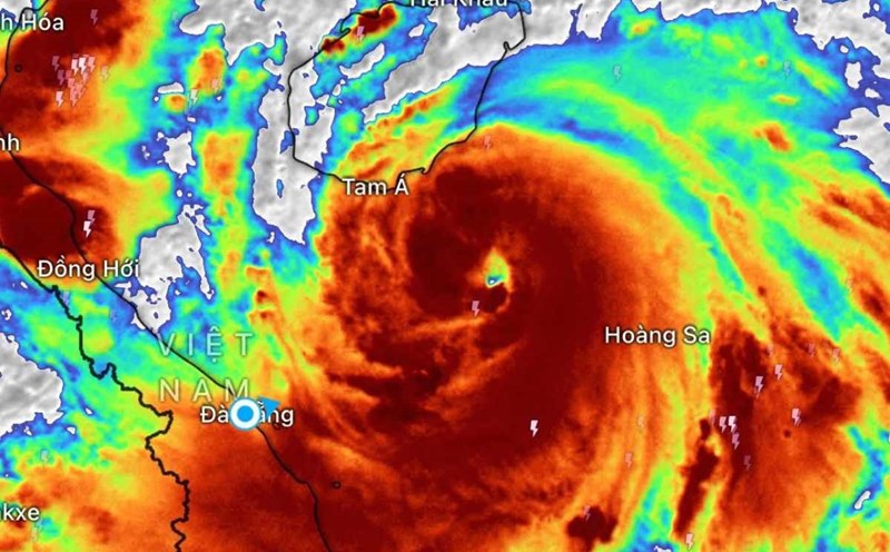
This morning (8.26), in the Gulf of Tonkin (Bach Long Vi, Cat Hai, Co To, Van Don, Hon Ngu), the wind is level 6-7, gusting to level 8, waves 2-5m, rough seas.
On land: Thanh Hoa - Nghe An, coastal Ninh Binh wind level 6-7, gust level 9.
Regarding heavy rain forecast: From early morning of August 26 to the end of August 26, the Northern Midlands and Delta, Lao Cai, Son La, Thanh Hoa - Ha Tinh: 50-100mm, some places over 200mm, risk of heavy rain over 100mm/3h.
Hanoi heavy rain with thunderstorms. No rain in Da Nang. Ho Chi Minh City has showers and thunderstorms in the late afternoon.