The cold front that is pouring straight from the Arctic to the eastern United States is forecast to peak on December 14-15, bringing strong gusts and very low temperatures. Many experts warn that this could be the deepest cold spell in recent years, or even the coldest since the end of 2022.
According to weather forecasters, if the temperature on the morning of December 15 drops to about -12 to -9 degrees Celsius, the eastern United States will experience the coldest weather since Christmas 2022.
December 15 has been identified as Weather Warning Day due to severe cold, as the high-intensity cold air mass continues to sweep deep to the south.
The main cause of this cold spell is the strong curve of thejet stream, creating a deep trough that allows the Arctic air to flow straight into the US without much obstruction. When these types of cold air waves appear, they are often accompanied by strong winds and this is no exception.
On December 14, winds are forecast to gust 40-55 km/h. In the morning, the temperature may still be around 4-6 degrees Celsius, but will decrease rapidly during the day. At around 6pm to 7am, the temperature felt due to the wind dropped to around -5 to -7 degrees Celsius, making the cold much harsher than the figure measured on the thermologist.
Entering the morning of December 15, the cold continued to increase. The current forecast shows that the lowest level on the morning of December 15 was about -9 degrees Celsius, equivalent to the coldest level recorded in 2025 on January 23.
However, if the actual temperature drops further, to -12 to -9 degrees Celsius, this will be the coldest morning in more than 2 years, since the severe cold spell at Christmas 2022.
For Vietnam, December 14 is the coldest day since the beginning of the month until Christmas. According to the Vietnam National Center for Hydro-Meteorological Forecasting, cold air continues to affect the North Central and Northwest regions.
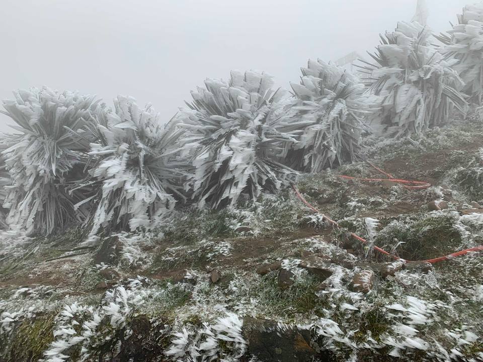
On the day and night of December 14, in the North Central region, there will be scattered rain and showers. In the Northern region, it is cold, some places are very cold; mountainous and midland areas are very cold, high mountainous areas have some places are very cold.
The lowest temperature in this cold air mass in the mountainous and midland areas of the North is generally from 7-10 degrees Celsius, in high mountainous areas, some places are below 5 degrees Celsius; in the Northern Delta, it is generally from 11-14 degrees Celsius; in the North Central region, it is generally from 12-15 degrees Celsius.
Hanoi area: Cold weather, some places are very cold. The lowest temperature in this cold air mass is generally 12-14 degrees Celsius.
At sea: In the Gulf of Tonkin, there are strong northeast winds of level 6-7, gusting to level 8, rough seas, waves 2.0-4.0m high.
The northern East Sea area (including Hoang Sa special zone) has strong northeast winds of level 7-8, gusting to level 9-10, rough seas, waves 4.0-6.0m high.
Warning of the possibility of natural disasters: The area from Nghe An to Hue City will have moderate rain, heavy rain, locally very heavy rain and thunderstorms; in Da Nang City and the east of Quang Ngai province, there will be rain, moderate rain, locally heavy rain and thunderstorms. During thunderstorms, there is a possibility of tornadoes, hail and strong gusts of wind.


