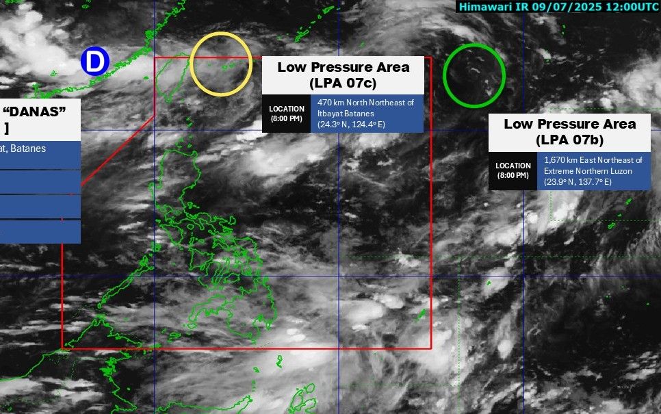
The latest storm/low pressure information from the Philippine Atmospheric, Geophysical and Astronomical Services Administration (PAGASA) said that a new low pressure area (07c) has formed and entered the Philippine Forecast Area (PAR).
At 2:00 a.m. on July 10, the center of low pressure 07c was at about 24.6 degrees north latitude, 125.0 degrees east longitude, 535 km northeast of Itbayat, Batanes. Although located in the PAR, this low pressure area is assessed to have a low chance of developing into a tropical depression in the next 24 hours.
At the same time, another low pressure area, LPA 07b, is moving outside the PAR, about 1,670 km east-northeast of the northernmost tip of Luzon. This low pressure area is also unlikely to strengthen into a tropical depression in the near future.
Also at 2am on 10.7, the location of the storm danas (formerly storm No. 2 in the East Sea, Bising storm according to the local name of the Philippines) was about 25 degrees North latitude, 116.1 degrees the Eastern East, weakened but caused heavy rains to pour down the coastal technology centers of China, while the rains due to the monsoon deep in the mainland caused dead landslides and flash floods on a strip of 1,400km.
PAGASA weather forecaster John Manalo said that in the coming days, the southwest monsoon will continue to dominate the weather in the Philippines. Due to the influence of southwest winds, the western area of Luzon Island, including the capital Manila, will continue to have showers and cloudy skies on July 10.
Palawan, western Visayas and Mindanao provinces will also experience gloomy weather with scattered rain. PAGASA warned people living in low-lying areas and near rivers and streams to be on guard against the risk of flash floods and landslides, especially in conditions where rocks and soil have become soaked with water after storm No. 2.
Although both new low pressure areas have not shown any signs of strengthening, the consecutive appearance of weather systems during the monsoon season is active, increasing the risk of prolonged rain, flooding and auxiliary natural disasters in many areas across the Philippines.
In Vietnam, the weather forecast bulletin of the Vietnam National Center for Hydro-Meteorological Forecasting said that from early morning to late afternoon of July 10, the mountainous and midland areas of the North will have moderate rain, heavy rain and thunderstorms, locally very heavy rain. The common rainfall is 20-40mm, in some places over 90mm.
From the night of July 10 to the night of July 11, the Northern region and Thanh Hoa will continue to have moderate rain, heavy rain and thunderstorms, locally very heavy rain. The common rainfall is 40-90mm, in some places over 200mm.
Warning of the risk of heavy rain >150mm in 3 hours
It is forecasted that on the day and night of July 12, the Northern region and Thanh Hoa will continue to have moderate rain, heavy rain, and some places will have very heavy rain. The common rainfall is 30-60mm, in some places over 100mm.
The total rainfall from the night of July 10-12 was generally 70-150mm, in some places over 300mm.
During thunderstorms, tornadoes, lightning, hail and strong gusts of wind may occur. Warning level of natural disaster risk due to heavy rain, tornadoes, lightning, hail: Level 1.


