Warning when storm No. 2 intensifies violently, warning of consequences when making landfall

Song Minh |

According to the latest storm news, storm No. 2 in the East Sea (storm Today) increased rapidly, gusting to level 15 on the afternoon of July 6.

The China Meteorological Administration (CWA) issued an unprecedented warning of an unprecedented overland typhoon for the entire island's major urban area on the morning of July 6, as Typhoon No. 2 today suddenly intensified and headed straight into the Taiwan Strait (China).

From only 6 initial warning points, the number has skyrocketed to 20 localities in less than 12 hours. All 6 major cities including Taipei, Tan Bac, Dao Vien, Tai Trung, Tai Nam, and Kaohsiung are included in the danger zone. People are required to be ready for extreme heavy rain, strong gusts of wind and the possibility of interruption of activities in the next 48 hours.

The CWA confirmed at 11am on July 6 that today, Danas has strengthened into a strong tropical storm, with sustained winds of 119 km/h, gusting up to 155 km/h. The center of the storm at 1:00 p.m. was determined to be only 210km southwest of the Penghu archipelago, moving north-northeast at a speed of 19-23 km/h.

CWA typhoon forecaster Wu Wan-hua said that today's storm " tides" will be strongest from the afternoon of July 6 to the morning of July 7, moving close to the west coast of Taiwan (China) through the Strait, causing widespread heavy rain and strong gusts of wind in mountainous and coastal areas.

The meteorological agency forecasts that the rain will increase rapidly this afternoon and evening in areas such as Taitung, Hoa Lien, Nghi Lan, in which the mountainous areas of Kaohsiung and Binh Dong may record extremely heavy rain, even local flash floods.

Due to the direct impact of storm No. 2 Danas in the Northern region from tonight, Taipei Mayor Chiang Wan-an will urgently meet with leaders of Tan Bac, Co Long and Dao Vien at 8:00 p.m. to decide whether to stop studying and working on July 7.

Meanwhile, the Philippine Atmospheric, Geophysical and Astronomical Services Administration (PAGASA) said Typhoon Today could return to the Philippine Forecast Area (PAR) on the night of July 6 or early morning of July 7, after intensifying off the Batanes.

Bao so 2 Danas co the quay lai PAR vao dem 6.7 hoac sang som 7.7. Anh: PAGASA
Storm No. 2 Today may return to PAR on the night of July 6 or early morning of July 7. Photo: PAGASA

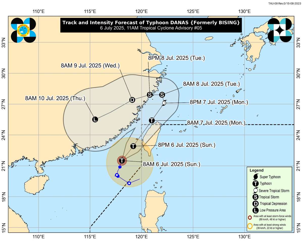
PAGASA warned of rough seas with waves as high as 4.5 m in Batanes and Babuyan, warning small boats and fishing boats not to go to sea under any circumstances.

On the same day, the storm forecast bulletin of the Vietnam National Center for Hydro-Meteorological Forecasting said that at 1:00 p.m. on July 6, the center of storm No. 2 was at about 22.1 degrees north latitude; 118.8 degrees east longitude, in the northeastern sea area of the North East Sea.

The strongest wind near the storm center is level 11-12 (103-133km/h), gusting to level 15. Mobility: North Northeast. speed: about 15 km/h.

At 1pm on July 7, the storm is forecast to continue moving north-northeast at a speed of 20-25 km/h, entering the waters of Fujian province (China), maintaining an intensity of level 11, gusting to level 14. Natural disaster risk level: level 3 in the northeastern sea area of the North East Sea.

Du bao duong di cua bao so 2 tren Bien Dong. Anh: Trung tam Du bao Khi tuong Thuy van Quoc gia Viet Nam
Forecast of the path of storm No. 2 in the East Sea. Photo: Vietnam National Center for Hydro-Meteorological Forecasting

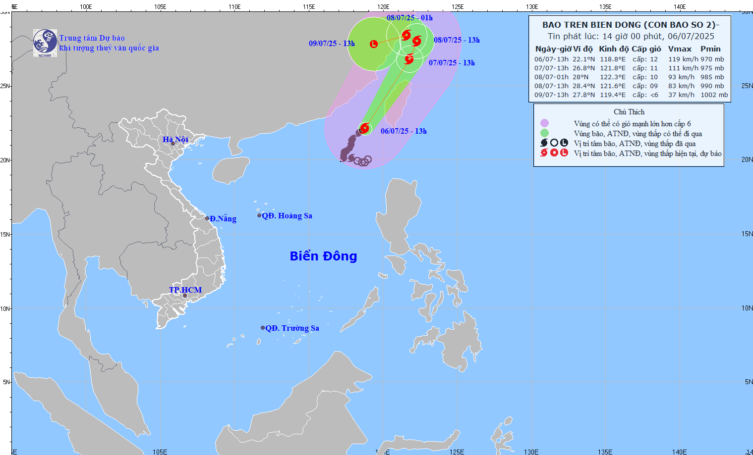
By 1:00 p.m. on July 8, the storm gradually moved slowly in the North-Northeast direction, then turned northwest at a speed of 10-15 km/h and began to weaken. The location will then be in the waters of Zhejiang province (China), with a drop in intensity to level 9, gusting to level 11.

By 1:00 p.m. on July 9, the storm continued to weaken into a low pressure area over the mainland of Zhejiang Province (China), with an intensity below level 6.

Song Minh
RELATED NEWS

Storm No. 2 in the East Sea threatens many areas

|

According to the latest storm news, the strongest wind near the center of storm No. 2 in the East Sea is level 10 (89-102 km/h), gusting to level 12, threatening many areas.

Forecast of the time when storm No. 2 in the East Sea will reach level 13, causing heavy rain and strong waves

|

According to the latest storm news, storm No. 2 in the East Sea is expected to strengthen strongly in the next 24 hours, gusting to level 13.

Warning of a 30m sunglable Tsunami waiting at the bottom of the sea in the super earthquake area

|

A landslide in the Cascadia subduction zone could bring up to 30m high sunslides, hitting coastal communities in just 15-30 minutes.

Hanoi Party Secretary sets deadline for completion of "most expensive road on the planet

|

Hanoi - Regarding the progress of the Ring Road 1 project (Hoang Cau - Voi Phuc section), the Hanoi Party Secretary requested to complete the entire roadbed before September 2, 2026; complete the construction of 2 overpasses on the route before December 31, 2026.

Live volleyball VTV Binh Dien Long An vs Binh Chung Thong Tin

|

Live volleyball match between VTV Binh Dien Long An and Binh Chung Thong Tin, taking place at 5:30 PM today (April 18).

Complete the installation of medical equipment at facility 2 of Bach Mai and Viet Duc Hospitals before June 30

|

Ninh Binh - The investor of Bach Mai Hospital and Viet Duc Friendship Hospital facility 2 project committed to complete the installation of equipment before June 30.

Salary reform from the Central to local levels, implemented in all 3 blocs

|

The Ministry of Home Affairs is assigned to carefully prepare the reform of salaries, allowances and other regimes from the Central to local levels, implemented in all 3 blocs.

Forecast of the risk of receiving strong storms and super typhoons in 2026

|

According to a representative of the meteorological agency, ENSO phase transition along with the impact of climate change leads to the risk of strong storms and super typhoons in 2026.

Storm No. 2 in the East Sea threatens many areas

Song Minh |

According to the latest storm news, the strongest wind near the center of storm No. 2 in the East Sea is level 10 (89-102 km/h), gusting to level 12, threatening many areas.

Forecast of the time when storm No. 2 in the East Sea will reach level 13, causing heavy rain and strong waves

Khánh Minh |

According to the latest storm news, storm No. 2 in the East Sea is expected to strengthen strongly in the next 24 hours, gusting to level 13.

Warning of a 30m sunglable Tsunami waiting at the bottom of the sea in the super earthquake area

Khánh Minh |

A landslide in the Cascadia subduction zone could bring up to 30m high sunslides, hitting coastal communities in just 15-30 minutes.