According to the storm forecast of the Philippine Atmospheric, Geophysical and Astronomical Services Administration (PAGASA), at 3:00 a.m. on July 6, storm No. 2 Danasing (local name Bising) was outside the Philippine Forecast Area (PAR). However, the low pressure trough left by the storm is still causing rain and bad weather in the far north of Luzon, especially Batanes province and neighboring areas.
At 3:00 a.m. on July 5, the center of the storm was about 400 km west of Itbayat Island, Batanes Province, at coordinates 21.1 degrees north latitude, 118.0 degrees east longitude.
Maximum winds near the center of the storm reached 110 km/h, gusting up to 135 km/h. The storm is moving slowly in the North-Northeast direction.
PAGASA recommends that people in affected areas be vigilant against flash floods, inundation, and landslides.
Meanwhile, according to the Vietnam National Center for Hydro-Meteorological Forecasting, at 4:00 a.m. on July 6, the center of storm No. 2 was at about 21.3 degrees north latitude; 117.9 degrees east longitude. The strongest wind near the storm center is level 10 (89-102km/h), gusting to level 12; moving slowly north at a speed of about 5km/h.
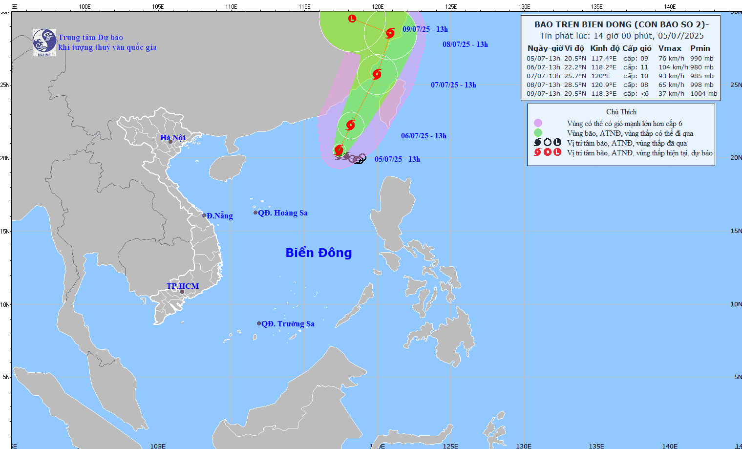
It is forecasted that by 4:00 a.m. on July 7, the center of the storm will be at 24.4 degrees north latitude, 119.7 degrees east longitude, in the waters of Fujian province (China). Storm intensity level 10-11, gust level 13. The northeastern sea area of the northern East Sea is at risk of level 3 natural disasters.
Storm No. 2 caused the northeastern sea area of the North East Sea to have storms and strong winds of level 7-9, near the center of the storm level 10-11, gusts of level 13, waves 4.0-6.0m high, and rough seas.
Meanwhile, the CWA issued a land warning for Typhoon leo leo at 8:30 a.m. on July 5. Airlines announced schedule changes on July 6.
A sea warning for the southwestern sea of Taiwan (China) has been in effect since the morning of July 5. CWA forecasters warn of strong winds and heavy rain, especially on July 6 as the storm moves northward across the Taiwan Strait (China). Today is expected to reach the northern part of the western Strait of Taipei on July 7 before moving off the island in the afternoon of July 7.
The land warning is effective for Gia Nghia city and Gia Nghia district, Taipei, Kaohsiung, Binh Dong and Penghu. The warning of extremely heavy rain will take effect in Nam Dau, Van Lam and Gia Nghia district from the evening of July 5 to the morning of July 6.
Ferry trips between the main island and remote islands were suspended on July 7, but the worsening weather situation forced ferry operators to stop services between Binh Dong and Tieu Luu Cau island on the afternoon of July 5.
Airlines announced the cancellation of domestic flights on July 6. However, Tigerair said some of its international flights will be rescheduled, with flights departing early in Taiwan (China). These changes apply to flights between Kaohsiung and Okinawa, Tokyo (Japan), from Kaohsiung to Kaohsiung (China) and from Kaohsiung to Taitung.