This is considered the strongest storm since the beginning of the year in this area.
According to the Taiwan Meteorological Administration (China), less than 1 hour after making landfall in Bo Dai town, Gia Nghia district, the center of the storm was located about 30km west-southwest of Gia Nghia, continuing to move northeast at a speed of 25km/h.
Today's storm wind radius covers the entire length of the Penghu archipelago, extending south to Mieu Lat, Nam Dau, Ta Dong and Hoa Lien districts, pushing the entire island of Taiwan (China) into a state of comprehensive threat.
Heavy rain and strong winds continue to affect southern Taiwan (China), while the central region has begun to record rapid increases in rainfall and wind.
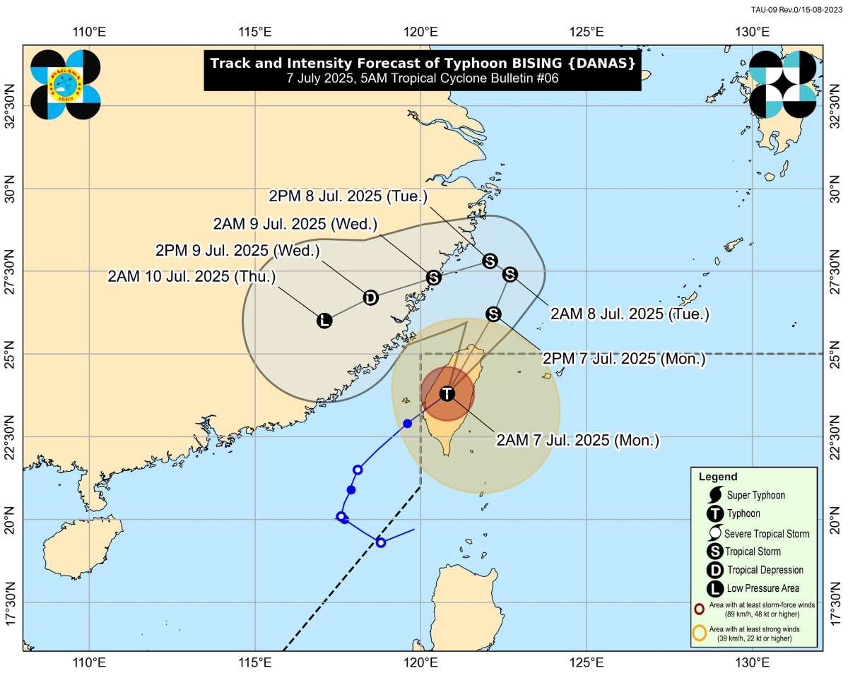
As of 10:00 p.m. on July 6, at least 28 people were injured and more than 2,850 people were forced to evacuate. The storm also caused power outages to 85,113 households, of which nearly 49,000 were still in the dark - according to the latest report from the Taiwan Emergency Response Center (China).
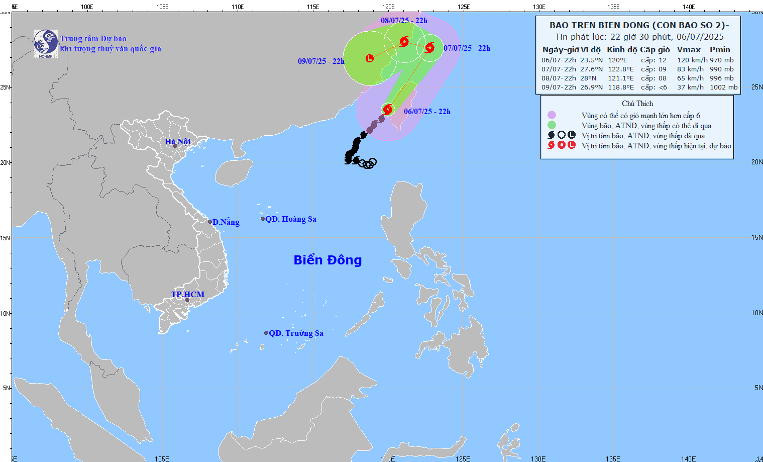
China's southeastern coast is also facing an imminent danger. On the morning of July 6, Quang Dong province issued an emergency response order when the center of storm No. 2 Today approached, only about 230km from San Dau city.
Immediately, all 361 offshore fishing vessels were ordered to return to port, and more than 2,000 people were evacuated from works at sea. Five coastal tourist areas of the province were forced to completely close.
A large-scale storm prevention campaign has been launched: 6 rescue helicopters, 21 patrol ships and 64 emergency response ships ready to deploy at coastal hot spots. Chinese authorities have warned people to be highly vigilant against heavy rain, flash floods, high tides and strong gusts of wind.
On the same day, Zhejiang Province in eastern China also declared a state of emergency response. Storm Today is forecast to enter the East China Sea on July 7 and is likely to make landfall from the afternoon to the evening of July 8 in the coastal area stretching from the central and southern part of Zhejiang province to the north of Fujian province.
China's National Meteorological Observatory has issued a yellow alert - the third highest warning level in the 4-level system - due to concerns that Typhoon Today will bring heavy rain and strong winds to the entire southern part of the country.
Meanwhile, the Vietnam National Center for Hydro-Meteorological Forecasting said that on the evening of July 6, storm No. 2 had left the East Sea and was no longer likely to return to the East Sea.
On July 7, the North East Sea area (including Hoang Sa special zone) and the sea area from Ca Mau to An Giang are having showers and thunderstorms.
The northeastern sea area of the North East Sea and the sea area from Khanh Hoa to Vinh Long will have strong southwest winds of level 5, sometimes level 6, gusting to level 7-8. Waves are 2.03.0m high.
All ships operating in the above areas are at risk of being affected by tornadoes, strong gusts of wind and big waves.