The latest storm information from the Philippine Atmospheric, Geophysical and Astronomical Services Administration (PAGASA) said that at 4:00 a.m. on November 18, the center of the storm was at about 18.0 degrees north latitude; 118.9 degrees east longitude, 145 km west of Sinait, Ilocos Surt, in the eastern sea of the northern East Sea. The strongest wind near the storm center is level 11-12 (103-133 km/h), gusting to level 15, air pressure 965 hPa, storm cloud radius 280 km. The storm is moving northwest at a speed of about 25 km/h.
The storm forecast of the Vietnam Center for Hydro-Meteorological Forecasting said that at 4:00 a.m. on November 19, the center of the storm was at about 19.1 degrees north latitude, 114.6 degrees east longitude; in the northern East Sea; about 370 km northeast of Vietnam's Hoang Sa archipelago. Storm intensity level 10, gust level 12. The storm is moving west-northwest at about 20 km/h, continuing to weaken. Dangerous area: latitude 16.5 -21.0 degrees north; east of longitude 113.0 degrees east. Level 3 natural disaster risk in the northern East Sea.
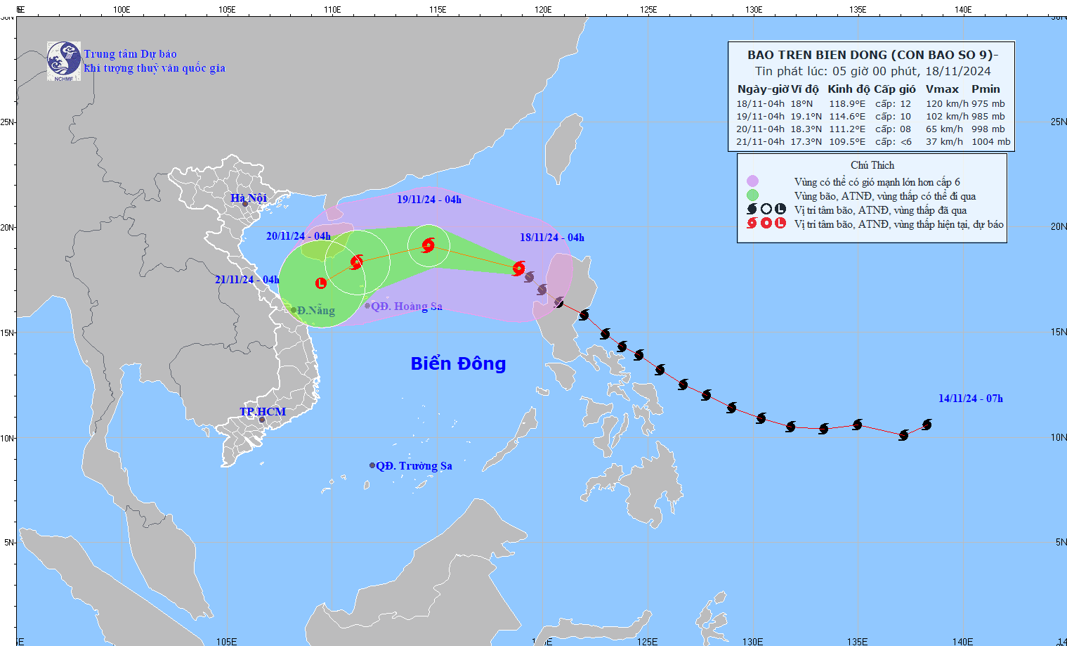
At 4:00 a.m. on November 20, the center of the storm was at about 18.3 degrees north latitude, 111.2 degrees east longitude; in the western area of the northern East Sea; about 210 km northwest of Hoang Sa archipelago of Vietnam. Storm intensity level 8, gust level 10. The storm is moving west-southwest, about 15 km/h, continuing to weaken.
It is forecasted that by 4:00 a.m. on November 21, the center of storm No. 9 will be at about 17.3 degrees north latitude, 109.5 degrees east longitude; in the sea off the Central Central Coast. The storm is below level 6, moving southwest at about 10 km/h, gradually weakening into a tropical depression, then a low pressure area.
Earlier, at around 5:20 p.m. on November 17, Super Typhoon Man-yi made its second landfall on the northeastern coast of the Philippines - the sixth major storm to hit the country in less than a month.
Before making landfall, according to PAGASA, the strongest winds near the center of the storm reached 185 km/h, gusting to 305 km/h in the late afternoon of November 17.
Man-yi is the 16th typhoon to hit the Philippines in 2024.
On the night of November 16, the storm made landfall in the eastern island province of Catanduanes in the central Philippines with the strongest winds near the center of the storm reaching 195 km/h.
As of the afternoon of November 18, there were no immediate reports of casualties from the storm, but it caused Catanduanes to lose power after knocking down trees and electricity poles.
It rained very little, but the wind was very strong and howling. Along a main alley here, the tide rose more than 7 meters near coastal houses. It was scary, Roberto Monterola, a disaster mitigation official in Catanduanes, told the AP.
Nearly half of the island province's 80,000 residents had taken shelter in evacuation centers before Typhoon Man-yi made landfall.
In the northern Philippines, more than 750,000 people have taken shelter in emergency shelters, including churches and a shopping mall, due to Typhoon Man-yi and two previous typhoons, according to civil defense official Cesar Idio.
The back-to-back typhoons and super typhoons that hit Luzon in just three weeks have killed at least 160 people, affected 9 million people, and caused such damage to communities, infrastructure, and farmland that the Philippines could be forced to import more rice.


