According to the press release of the Ministry of Foreign Affairs: On February 21, 2025, based on Resolution No. 68/NQ-UBTVQH15 dated February 14, 2025 of the National Assembly Standing Committee, the Government of the Socialist Republic of Vietnam issued a Declaration on the base route used to calculate the extension of Vietnam's sovereignty in the Gulf of Tonkin.
The determination of the baseline in the Gulf of Tonkin is to exercise Vietnam's rights and obligations according to the provisions of the 1982 United Nations Convention on the Law of the Sea (UNCLOS) and in accordance with the 2012 Law of the Sea of Vietnam.
The basis for calculating the latitude of Vietnam's sovereignty in the Gulf of Tonkin is determined based on UNCLOS regulations, in accordance with the geographical and natural characteristics of the Gulf of Tonkin and does not affect international treaties to which Vietnam is a member or a member.
The basis for calculating the extension of Vietnam's sovereignty in the Gulf of Tonkin is the basis for determining the boundaries and scope of Vietnam's sea areas according to the provisions of UNCLOS and the Gulf of Tonkin Decentralization Agreement signed between Vietnam and China in 2000, creating an additional legal basis to protect and exercise Vietnam's sovereignty, sovereign rights, and jurisdiction, serving economic development, marine governance, and promoting international cooperation.
The Declaration stated: In accordance with the provisions of the Law of the Vietnam Sea, issued on June 21, 2012, based on Resolution No. 68/NQ-UBTVQH15 of the Standing Committee of the National Assembly of the Socialist Republic of Vietnam, term XV, approving the determination and promulgation of the basis for calculating the width of Vietnam's sovereignty in the Gulf of Tonkin, the Government of the Socialist Republic of Vietnam announced the basis for calculating the sovereignty of the Socialist Republic of Vietnam in the Gulf of Tonkin as follows:
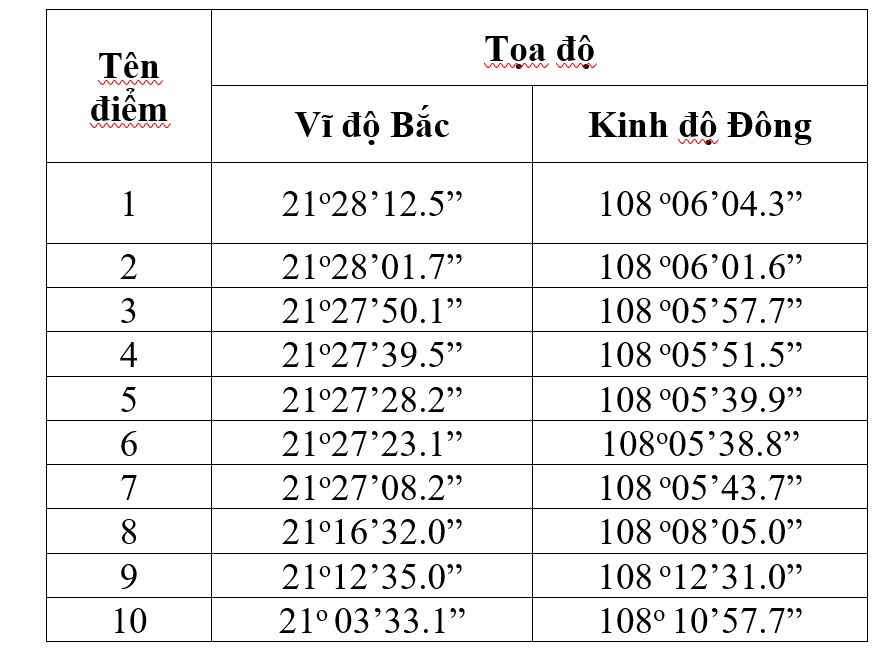
Article 1. The base line used to calculate the lanh daoence of the mainland territory of Vietnam in the Gulf of Tonkin includes the following sections connecting the points as listed below:
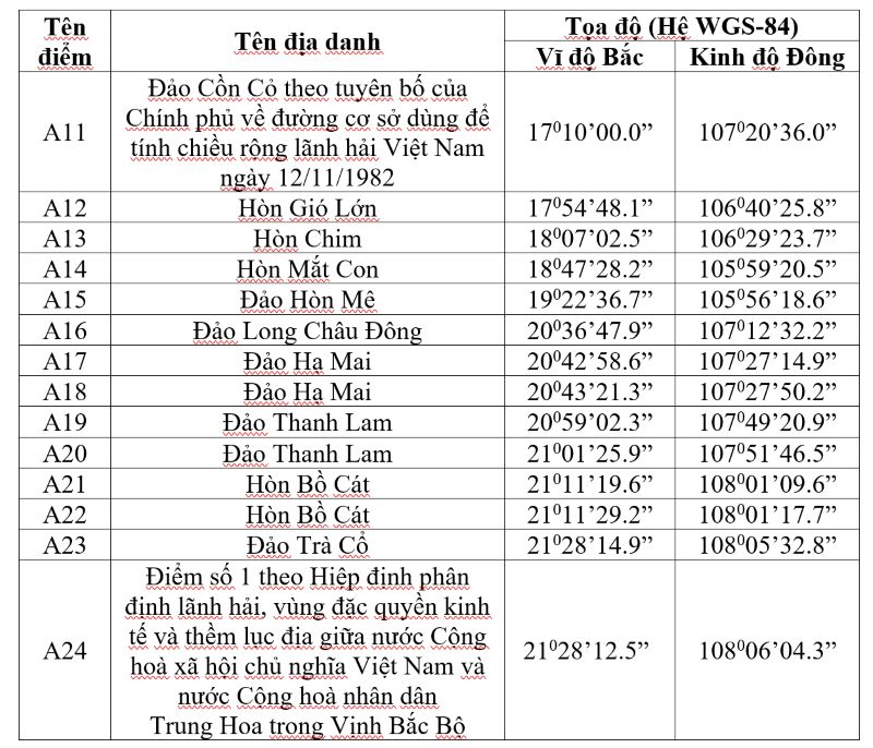
Article 2. The base road used to calculate the lanh dao width of Bach Long Vi island is the lowest tidal culvert along the island's coast.
Article 3. The border outside the territory of the Socialist Republic of Vietnam in the Mekong Delta is determined by 9 points along the lanh dao dividing line between the Socialist Republic of Vietnam and the People's Republic of China in the Gulf of Tonkin and point 10 with coordinates determined over the sea of Vietnam. Coefficients of the scores are listed below: