
On the morning of September 14, the Central Hydrometeorological Station issued a warning of flash floods, landslides and subsidence due to rain and floods in Da Nang City.
In the past 24 hours (from 1:00 AM on September 13 to 1:00 AM on September 14), some mountainous areas in Da Nang city experienced moderate to heavy rain, with very heavy rain in some places.
Notably, the soil moisture model shows that some areas of the city have nearly saturated, over 85%, or reached a state of saturation. This is a condition that increases the risk of landslides and landslides on slopes even though the next rainfall is not too large.
Da Nang is forecast to continue to have light rain, common rainfall of 5-15mm, in some places over 30mm. The meteorological agency warns of the risk of flash floods on small rivers and streams in mountainous areas; landslides on slopes and land subsidence, disaster risk level 1.


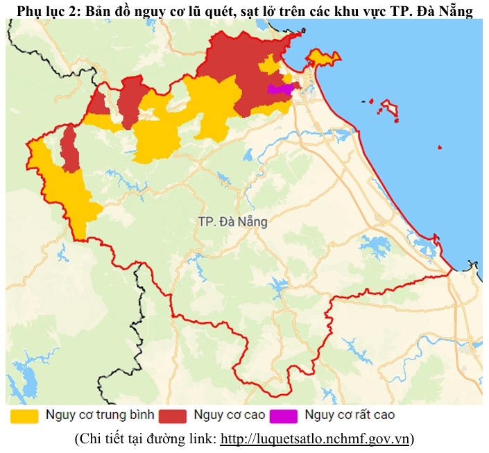
The warning list includes 18 communes and wards, including: Ba Na, An Khe, A Vuong, Hoa Vang, Hung Son, Hai Van, Hoa Khanh, Tay Giang, Ben Hien, Dong Giang, Hoa Tien, La Dee, La Eee, Lien Chieu, Son Tra, Song Kon, Song Vang and Thuong Duc.
Some locations that need special attention are the positive taluy of the road to Ba Na - Suoi Mo tourist area; National Highway 14G through Hoa Vang; La Son - Tuy Loan expressway, Hai Van pass; slopes and taluys on Son Tra peninsula and many mountainous residential areas in the west of the city.
The risk map attached to the bulletin also shows that many areas north, west and northwest of Da Nang are in a medium to high risk zone, some points at very high levels are experiencing landslides and flash floods.
The meteorological agency warns that flash floods and landslides can threaten people's lives, cause local traffic congestion, damage works and affect production activities. People in mountainsides, taluys, and riverside areas need to be especially vigilant against unusual signs such as cracked soil, falling rocks, strong cloudy water flow, or leaning trees.


