Storm No. 1 is about to form and strengthen, affecting the mainland, causing heavy rain

AN AN |

According to the representative of the meteorological agency, the current tropical depression scenario is likely to strengthen into storm No. 1, which could cause heavy rain in the Central provinces.

The development of the tropical depression that is likely to strengthen into a storm is being closely monitored by the meteorological agency. The reporter had an interview with Dr. Hoang Phuc Lam - Deputy Director of the National Center for Hydro-Meteorological Forecasting - about the comments to note.

ien si Hoang Phuc Lam - Pho Giam doc Trung tam Du bao Khi tuong Thuy van Quoc gia cung cap thong tin du bao thoi tiet dang chu y sap toi.
Dr. Hoang Phuc Lam - Deputy Director of the National Center for Hydro-Meteorological Forecasting - said that storm No. 1 is likely to strengthen after forming. Photo: An An

Dr. Hoang Phuc Lam, can you update the latest information on the location and intensity of the tropical depression in the East Sea?

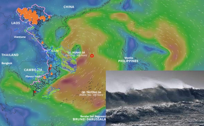
- This afternoon (September 10), the tropical depression was at about 15.3 degrees north latitude; 114.8 degrees east longitude, about 360km east-southeast of Hoang Sa archipelago. The strongest wind near the center of the tropical depression is level 6 - 7 (39 - 61km/h), gusting to level 9.

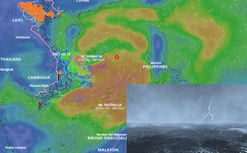
It is forecasted that in the next 24 hours, the tropical depression will move west-northwest and then likely strengthen into a storm - storm No. 1. After strengthening, storm No. 1 continues to move west-northwest and strengthen.

So what are the immediate impacts to be noted for this tropical depression, sir?

- The sea weather will be affected first by the tropical depression. The North East Sea area (including the Hoang Sa archipelago), the North East Sea area has thunderstorms and strong winds of level 6 - 7, then increased to level 8, gusting to level 11. The strongest intensity of the storm could reach level 10 - 11.

The offshore sea area from Quang Tri to Quang Ngai, the Gulf of Tonkin sea area is likely to have strong winds of level 7, some places have level 8, gusts of level 10, waves from 3 - 5m high. The sea is very rough.

Sir, with current forecasts, will this tropical depression, after strengthening into a storm, affect the weather on land?

- With the current scenario of movement and the possibility of strengthening into a storm, storm No. 1 can cause heavy rain in the Central provinces. Specifically, on the day and night of June 11, the South Central region will have moderate rain, heavy rain, locally very heavy rain with common rainfall of 30 - 80mm, some places over 150mm.

From the night of June 11 to June 13, the Central Central and Northern Central Highlands regions will have moderate rain, heavy rain and thunderstorms, with some places having very heavy rain.

The common rainfall in the Central Central region (from Quang Binh to Quang Ngai) is about 100 - 300mm, some places over 450mm. The Northern Central Highlands region will have common rainfall of 70 - 150mm, some places over 200mm.

We warn of the risk of local heavy rain (rainfall greater than 200mm within 6 hours). The development of rain is still very complicated, depending on the direction of movement and the impact of the tropical depression and then the storm.

In addition, the southwest monsoon will increase its activity, so it is forecasted that on the day and night of June 11, the Central Highlands and the South will also have moderate rain, heavy rain, locally very heavy rain with common rainfall of 30 - 80mm, some places over 150mm.

Sincerely thank you!

AN AN
TIN LIÊN QUAN

Forecast of the location of the eye of storm No. 1 when it formed and the path afterwards

|

According to the meteorological agency, in the next 24 hours, the tropical depression is forecast to strengthen into storm No. 1 with the center in the area east of Hoang Sa archipelago.

Tropical depression is about to strengthen into storm No. 1, forecast affected areas

|

According to the representative of the meteorological agency, the tropical depression is likely to strengthen into storm No. 1 in the morning or afternoon of June 11.

Assessing the path scenario of the low pressure area when it strengthens into storm No. 1

|

According to the representative of the meteorological agency, the most likely scenario is that the low pressure area will enter the Hoang Sa archipelago of Vietnam after strengthening into a storm, then change direction to the north.

Miss Vietnam Ha Truc Linh: I like Soobin, Jun Pham, I used to hunt for tickets to the show Anh Trai

|

Miss Vietnam 2024 Ha Truc Linh has revealed her love for the show "Call Me by Fire".

2 cajuput trees nearly 30 years old in the ward police headquarters in Dak Lak were cut down

|

Dak Lak - Two cajuput trees in the ward police headquarters were cut down. Currently, relevant units are coordinating and handling the case.

Germany declares Russia must compensate Ukraine with 500 billion euros

|

German Chancellor Friedrich Merz said Russia was obliged to compensate Ukraine for about 500 billion euros.

Fire at a grocery store signboard and then spread to a fried chicken shop in Ho Chi Minh City

|

HCMC - The hang at Ly Thai To roundabout suddenly caught fire, then spread to the fried chicken restaurant next door.

For the first time, a Bollywood film was filmed in Son Doong Cave

|

SILAA is the first Bollywood film shot at Son Doong Cave. The film is also set in a series of other famous places such as Cao Bang, Ninh Binh...

Forecast of the location of the eye of storm No. 1 when it formed and the path afterwards

LINH ANH |

According to the meteorological agency, in the next 24 hours, the tropical depression is forecast to strengthen into storm No. 1 with the center in the area east of Hoang Sa archipelago.

Tropical depression is about to strengthen into storm No. 1, forecast affected areas

LINH ANH |

According to the representative of the meteorological agency, the tropical depression is likely to strengthen into storm No. 1 in the morning or afternoon of June 11.

Assessing the path scenario of the low pressure area when it strengthens into storm No. 1

LINH ANH |

According to the representative of the meteorological agency, the most likely scenario is that the low pressure area will enter the Hoang Sa archipelago of Vietnam after strengthening into a storm, then change direction to the north.