Storm No. 1 is about to strengthen, forecasting the most notable impact on the mainland of Vietnam

AN AN |

According to the representative of the meteorological agency, storm No. 1 Wutip will increase in intensity in the next 24 hours, affecting both the weather at sea and on land.

Storm No. 1 Wutip is showing signs of strengthening and storm forecast information is continuously being updated by the meteorological agency.

The reporter had a quick discussion with Mr. Vu Anh Tuan - Deputy Head of Weather Forecast Department, National Center for Hydro-Meteorological Forecasting about the notable impacts of the storm.

Mr. Vu Anh Tuan provided information on the impact forecast of storm No. 1.

Sir, could you please tell us the current location of the storm and how it will develop in the coming hours?

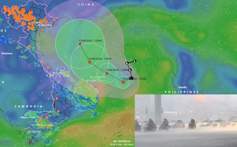
- Our latest update at 4:00 p.m. on June 11, the center of storm No. 1 was at about 16.8 degrees north latitude; 111.9 degrees east longitude in the Hoang Sa archipelago.

The strongest wind near the storm center is level 8 (62-74km/h), gusting to level 10; moving west-northwest at a speed of about 15km/h.

By the morning of June 12, storm No. 1 is likely to change direction, towards Hainan Island (China) and continue to strengthen.

When in the south of Hainan Island (China), the storm intensity may be level 10, gusting to level 13.

Theo ong Vu Anh Tuan, bao so 1 se gay mua to den rat to o Trung Trung Bo va phia bac Tay Nguyen trong dem nay 11.6.
According to Mr. Vu Anh Tuan, storm No. 1 will cause heavy to very heavy rain in the Central Central region and the northern Central Highlands tonight, June 11.

What is the scenario for storm No. 1 after that, will it change direction, towards the Gulf of Tonkin or not, sir?

- The high-probability scenario for Typhoon No. 1 is that it will cross Hainan Island (China) and move north-northeast into the southern mainland of China.

However, a low-probability scenario is that Typhoon No. 1 will circle west of Hainan Island (China) and move east of the Gulf of Tonkin; then move inland south of China.

With such scenarios, what are the forecasts for the notable impacts of storm No. 1, sir?

- Regardless of the scenario, the west of the North East Sea (including the Hoang Sa archipelago) will have strong winds of level 8 - 9, gusting to level 11, near the storm's eye level 9 - 10, gusting to level 13, waves 3 - 5m high, near the storm's eye 4 - 6m, very rough seas.

From the night of June 11, the offshore sea area from Quang Tri to Quang Ngai will have winds gradually increasing to level 6 - 7, the area near the storm's eye will have level 8, gusts of level 10, waves 3 - 5m high, very rough seas.

Note that the sea area east of the Gulf of Tonkin will have winds gradually increasing to level 6 - 7, then increasing to level 8, gusting to level 10. In one scenario, if the storm enters the Gulf of Tonkin, the wind may be strong at level 8 - 9, gusting to level 11 - 12 - this scenario is less likely but still need to be cautious.

The circulation of storm No. 1 combined with the southwest monsoon will have heavy to very heavy rain in the Central Central region and the Northern Central Highlands from the night of June 11 to June 13, with common rainfall from 100 - 350mm. In particular, Quang Tri, Hue, and Quang Nam may experience some places with over 400 - 450mm of rain.

We have specifically warned of the risk of local heavy rain (rainfall greater than 200mm within 6 hours). This is a dangerous scenario, which can cause flash floods and landslides, especially in the mountainous areas of the Central Central region and the northern Central Highlands.

Sincerely thank you!

AN AN
TIN LIÊN QUAN

Provinces with the heaviest rain due to storm No. 1, warn of dangerous weather and what to do immediately

|

Forecast of key areas of heavy rain due to storm No. 1 Wutip are Da Nang, Hue, Quang Nam, Gia Lai, Kon Tum...

Forecast of 2 scenarios of storm No. 1 Wutip and heavy rain in the next 3 days

|

According to the representative of the meteorological agency, the circulation of storm No. 1 Wutip combined with the southwest monsoon caused heavy rain in the Central region and the northern Central Highlands from the afternoon of June 11.

Forecast of factors that risk sudden intensification of storm No. 1

|

Scientists are paying special attention to the relatively strong southwest monsoon, which is a source of moisture that can trigger a sudden increase in storm No. 1.

Han River explodes with the top-notch fireworks display of the Chinese champion

|

Da Nang - China's Yangfeng Jiangxi fireworks team has officially won the DIFF 2025 Champion title, with a prize worth 20,000 USD.

Mr. Trump announces tariffs on the EU and Mexico

|

President Donald Trump said the US will impose a 30% tariff on goods from the EU and Mexico.

Hour 9: Lover in the Night - Part 2

|

Hour 9 No. 162 - The young assistant is noticed by the female director, but he is in love with a girl of the same age. The director tries to divide. What will happen to this love affair?

The Department of Foreign Security receives the title of Hero of the People's Armed Forces

|

The Department of Foreign Security received the title of Hero of the People's Armed Forces on July 12.

The news of "CSGT rescuing a girl from the coffin" is fabricated

|

Thanh Hoa - The clip titled "Shock - Traffic police stop a funeral vehicle in the middle of the road, a girl suddenly comes out of the coffin" is completely untrue.

Provinces with the heaviest rain due to storm No. 1, warn of dangerous weather and what to do immediately

AN AN |

Forecast of key areas of heavy rain due to storm No. 1 Wutip are Da Nang, Hue, Quang Nam, Gia Lai, Kon Tum...

Forecast of 2 scenarios of storm No. 1 Wutip and heavy rain in the next 3 days

NHÓM PV |

According to the representative of the meteorological agency, the circulation of storm No. 1 Wutip combined with the southwest monsoon caused heavy rain in the Central region and the northern Central Highlands from the afternoon of June 11.

Forecast of factors that risk sudden intensification of storm No. 1

LINH ANH |

Scientists are paying special attention to the relatively strong southwest monsoon, which is a source of moisture that can trigger a sudden increase in storm No. 1.