Latest forecast of the path of storm No. 2 and areas strongly affected

AN AN |

According to the meteorological agency, storm No. 2 is likely to strengthen and cause storms in the northeastern sea area of the North East Sea.

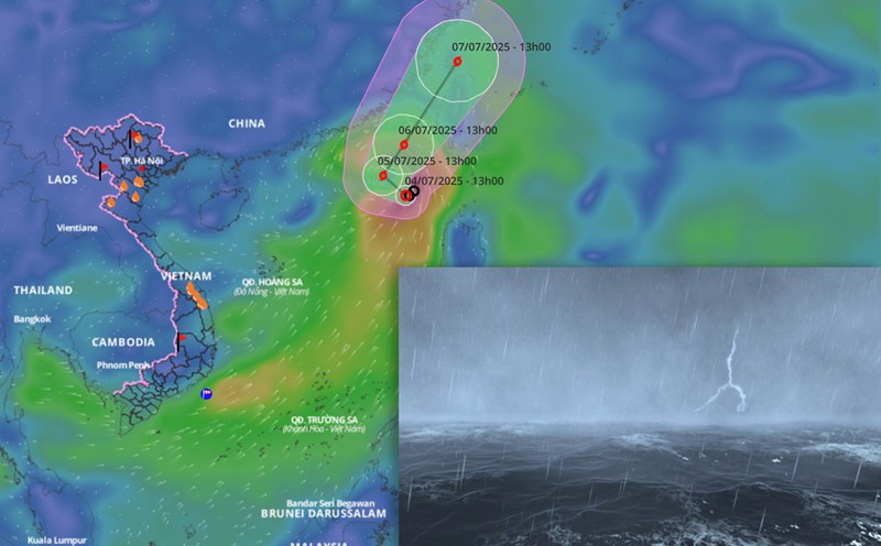
According to the National Center for Hydro-Meteorological Forecasting, at 4:00 a.m. this morning, July 5, the center of storm No. 2 was at about 20.1 degrees north latitude; 117.4 degrees east longitude. The strongest wind near the storm center is level 8 (62 - 74km/h), gusting to level 10; moving west-northwest at a speed of 5 - 10km/h.

It is forecasted that in the next 24 hours, the storm will move north at a speed of 5 - 10km/h and is likely to strengthen. At 4:00 a.m. on July 6, the center was at about 21.8 degrees north latitude; 117.4 degrees east longitude, in the northeastern sea of the East Sea.

The strongest wind near the storm center is level 9 - 10, gusting to level 12. The storm danger zone in the next 24 hours is from 18.5 to 23.5 degrees north latitude; from 115.5 to 120 degrees east longitude. The natural disaster risk level is level 3, the affected area is the northeastern sea area of the North East Sea.

It is forecasted that in the next 48 hours, the storm will continue to move north-northeast at a speed of about 15km/h. The center is located at about 24.6 degrees north latitude; 119.4 degrees east longitude, in the waters of Fujian province (China). Intensity level 10 - 11, gust level 13. The danger zone is located north of latitude 19.5 degrees north latitude and east of longitude 115.5 degrees east longitude. The natural disaster risk level is level 3, the affected area is the northeastern sea area of the North East Sea.

It is forecasted that in the next 72 hours, the storm will move north-northeast at a speed of about 15km/h. The center is located at about 27.8 degrees north latitude; 120.6 degrees east longitude, on the mainland along the coast of Zhejiang Province (China). Intensity level 10, gust level 12.

From the next 72 to 120 hours, the storm tends to move northwest at a speed of about 5 - 10km/h and gradually weaken.

Regarding the impact of the storm, the northeastern sea area of the North East Sea will have storms and strong winds of level 7. The area near the storm's eye has strong winds of level 8-10, gusts of level 12, very rough seas. Waves are 3 - 5m high. Ship operating in the above-mentioned dangerous areas are likely to be affected by thunderstorms, whirlwinds, strong winds, and large waves.

AN AN
RELATED NEWS

Forecast of heavy rain and storm and tropical depression trends in July

|

According to the meteorological agency, the number of storms or tropical depressions in July in the East Sea is about 1-2.

Forecast of bad weather due to tropical depression about to strengthen into storm

|

According to the meteorological agency, the tropical depression is currently at level 7, gusting to level 9 and may strengthen into a strong storm of level 8 - 9, gusting to level 11 in the next 24 hours.

Tropical depression likely to strengthen into a storm in the next 24 hours

|

It is forecasted that in the next 24 hours, the tropical depression will move northwest at a speed of 5 - 10km/h and is likely to strengthen into a storm.

Factory fire in HCMC causes many properties to be burned down

|

Ho Chi Minh City - On June 10, the police are investigating the cause of the fire at a wood company factory in Quarter 1, Binh Co Ward, which caused many properties to be burned down.

Gold price update morning of June 10th: Continuing the downward trend, falling below the 4,300 USD/ounce mark

|

Gold price update morning of June 10th: World gold continues to fall sharply, possibly pulling domestic gold prices down as the new trading session opens.

Weather today June 10: Southern region has thunderstorms in the late afternoon and evening

|

Weather today June 10, the area from Thanh Hoa to Hue has scattered showers and thunderstorms, locally heavy rain in some places. Southern region in the late afternoon and evening has scattered showers and thunderstorms.

A 2,432 billion VND road project section in Hanoi will be temporarily opened to traffic in June

|

Hanoi - Ring Road 2.5 section Nguyen Trai - Dam Hong is under construction, it is expected that about 500m at the end of the route will be temporarily opened to traffic in June.

Forecast of heavy rain and storm and tropical depression trends in July

AN AN |

According to the meteorological agency, the number of storms or tropical depressions in July in the East Sea is about 1-2.

Forecast of bad weather due to tropical depression about to strengthen into storm

LINH ANH |

According to the meteorological agency, the tropical depression is currently at level 7, gusting to level 9 and may strengthen into a strong storm of level 8 - 9, gusting to level 11 in the next 24 hours.

Tropical depression likely to strengthen into a storm in the next 24 hours

AN AN |

It is forecasted that in the next 24 hours, the tropical depression will move northwest at a speed of 5 - 10km/h and is likely to strengthen into a storm.