Forecast of when storm No. 12 will start to get off the track when encountering cold air

AN AN |

It is forecasted that this evening, October 19, the East Sea will welcome storm No. 12 Fengshen; the path is likely to change due to interaction with cold air.

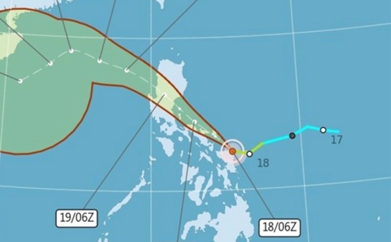
Latest update from the National Center for Hydro-Meteorological Forecasting, at 7:00 a.m. on October 19, the center of storm Fengshen was at about 14.1 degrees north latitude; 121.5 degrees east longitude, in the area east of the central Philippines. The strongest wind near the storm center is level 8 (62 - 74 km/h), gusting to level 10. The storm is moving west-northwest at a speed of about 20 km/h.

It is forecasted that in the next 24 hours, the storm will move northwest at a speed of 20-25 km/h and is likely to strengthen.

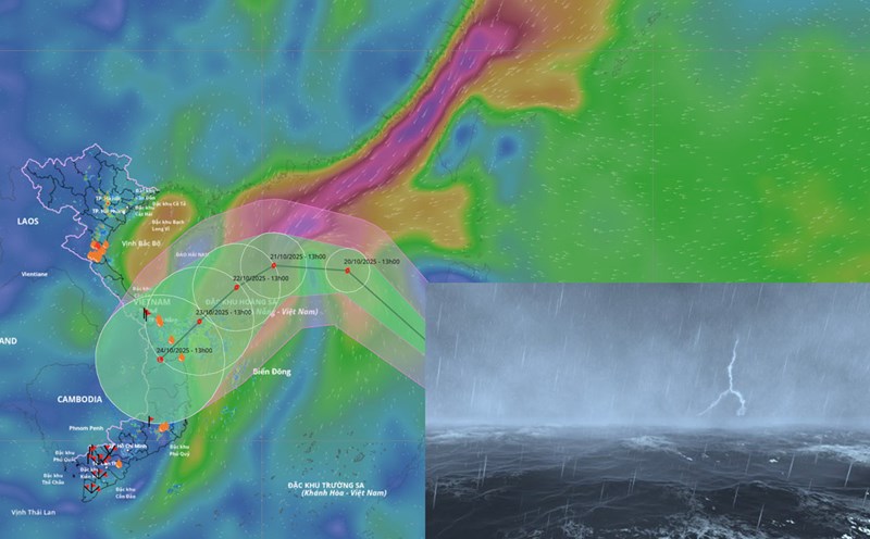
Around this afternoon and evening, October 19, the storm entered the East Sea and became storm No. 12. At 7:00 a.m. on October 20, the center of the storm was at about 17.8 degrees north latitude; 117.8 degrees east longitude, in the sea east of the northern East Sea. Strong wind level 9, gust level 11.

The danger zone in the next 24 hours will be north of the latitude of 15 degrees north; east of the longitude of 117.5 degrees east. The natural disaster risk level is level 3 for the eastern sea area of the northern East Sea.

It is forecasted that in the next 48 hours, the storm will continue to move northwest at a speed of about 20 km/h and is likely to strengthen. At 7:00 a.m. on October 21, the center of the storm was at about 18.5 degrees north latitude; 113.1 degrees east longitude, in the eastern sea of the northern East Sea, about 220 km northeast of the Hoang Sa special zone. Strong wind level 10-11, gust level 13.

The danger zone is north of latitude 16 degrees north; east of longitude 113 degrees east. Level 3 natural disaster risk for the northern East Sea area.

It is forecasted that in the next 72 hours, the storm will change direction, the cause of which is interaction with the cold air mass flowing down, causing the storm to depart. The storm will move west-southwest at a speed of about 10 km/h. At 7:00 a.m. on October 22, the center of the storm was at about 17.1 degrees north latitude; 111.3 degrees east longitude, in the sea west of the Hoang Sa special zone. Strong wind level 10, gust level 13.

The danger zone is north of latitude 15.5 degrees north; within longitude 110-115 degrees east. The natural disaster risk level is level 3 for the northern East Sea area, including the Hoang Sa special zone.

In the next 72 to 120 hours, the storm will move mainly southwest, traveling about 10-15 km per hour and tend to weaken gradually.

Regarding the impact of the storm, from October 19, the sea area east of the northern East Sea will have winds gradually increasing to level 6-7; the area near the storm's eye will have strong winds of level 8-9, gusts of level 11, waves 2.5 - 5 m high, very rough seas.

From October 20 to 22, the northern East Sea area (including Hoang Sa special zone) is likely to be affected by strong winds of level 10-11, gusting to level 13. All ships operating in the above dangerous areas are likely to be affected by thunderstorms, whirlwinds, strong winds and large waves.

AN AN
RELATED NEWS

Forecast of 5 provinces with the heaviest rain next week due to storm No. 12 combined with cold air

|

According to the representative of the meteorological agency, the combination of cold air and the circulation of storm No. 12 will increase heavy rain in Ha Tinh to Quang Ngai from October 23.

Storm No. 12 Fengshen enters the East Sea, many stations forecast areas to strengthen warning

|

Typhoon Fengshen (Phong Than, name in the Philippines is Ramil) made landfall in Gubat, Sorsogon, Philippines on the evening of October 18.

Cold air has a strong impact since October 20, the lowest temperature forecast in the North

|

According to the representative of the meteorological agency, from October 20, the northern provinces will have a significant drop in temperature due to the strengthening of cold air, the lowest temperature in mountainous areas will be below 20 degrees Celsius.

About to welcome storm No. 12, strengthening when entering the East Sea, then changing direction

|

Typhoon Fengshen tends to strengthen as it enters the East Sea, becoming storm No. 12, then changing direction due to cold air and gradually weakening.

Reasons for temporary closure of Russian market in the center of Ho Chi Minh City

|

HCMC - Nga Market at 125 Hai Ba Trung is temporarily closed after controversy due to its location in the core heritage area, close to Nguyen Van Binh Book Street.

Khanh Hoa reviews forest animal farming facilities after the crow and crocodile crop appeared in residential areas

|

Khanh Hoa - Forest rangers tighten facilities for raising common wild animals, endangered, precious, rare wild animals...

The scandal of the accident between a relief convoy car and a car, the car owner has agreed to repair it

|

Thanh Hoa - After many controversies related to the price of repairing the car in the collision between the flood relief team's car and the car, the car owner agreed to repair the car.

The large bridge on Ring Road 4 has been closed, the final items are under construction

|

Hanoi - The railway overpass under the Ring Road 4 parallel road project has been closed, the contractor is implementing the final items.

Forecast of 5 provinces with the heaviest rain next week due to storm No. 12 combined with cold air

LINH ANH |

According to the representative of the meteorological agency, the combination of cold air and the circulation of storm No. 12 will increase heavy rain in Ha Tinh to Quang Ngai from October 23.

Storm No. 12 Fengshen enters the East Sea, many stations forecast areas to strengthen warning

Thanh Hà |

Typhoon Fengshen (Phong Than, name in the Philippines is Ramil) made landfall in Gubat, Sorsogon, Philippines on the evening of October 18.

Cold air has a strong impact since October 20, the lowest temperature forecast in the North

LINH ANH |

According to the representative of the meteorological agency, from October 20, the northern provinces will have a significant drop in temperature due to the strengthening of cold air, the lowest temperature in mountainous areas will be below 20 degrees Celsius.