This afternoon, July 21, Ms. Nguyen Thanh Binh - Chief Forecaster of the remote Nutritional Forecast Department, National Center for Hydro-Meteorological Forecasting provided the latest comments on storm No. 3 Wipha.
Sir, could I please tell you if the current status of storm No. 3 Wipha has any notable changes?
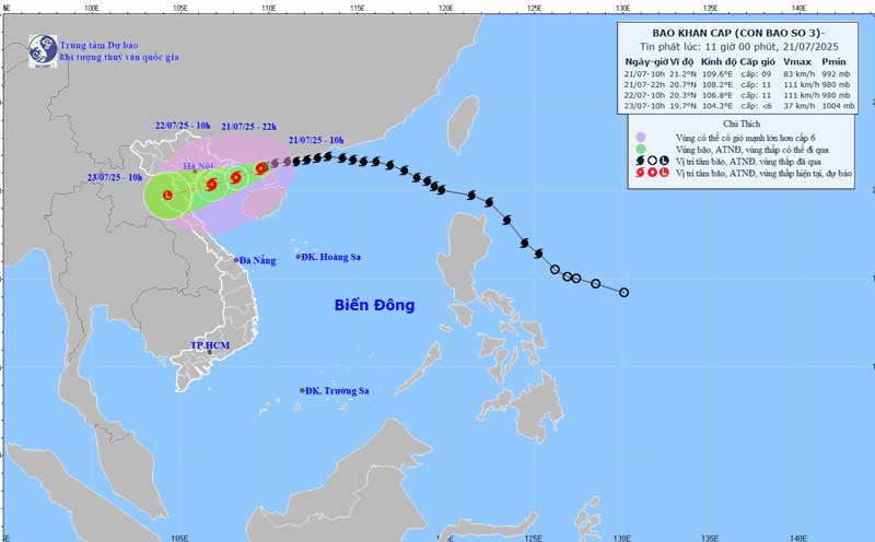
- Last night and early this morning, July 21, there was a change in storm No. 3, which was the storm making landfall in southern China, passing through the Lusian Peninsula.
Early this morning, July 21, when moving from the Lusian Peninsula to the Gulf of Tonkin, the storm's speed tended to decrease and slow down. But since this morning, when it reached the Gulf of Tonkin, the storm has tended to accelerate. Currently, the average speed of the storm is 15km/h, in the West Northwest direction.
Since this morning, the rain in the North has been sparse, with no heavy rain recorded. When is the rain forecast to start to increase, sir?
- The circulation of storm clouds is quite large. Currently, on satellite cloud images, it can be seen that the storm's circulation has covered the entire Northeast region and extended to the east of the Loi Chau peninsula. However, the thick cloud with convective clouds developing can cause rain within a narrow range. Therefore, the capital Hanoi and some provinces in the plains today do not have sunshine but there has not been much rain.
With the storm moving into the Gulf of Tonkin, the cloud organization will stabilize and the intensity may increase.
In the coming hours, as the storm moves closer to the coastal areas of Vietnam, the convective cloud area will get closer and the rain will increase.
According to our calculations, the rain will increase this evening and will rain the heaviest tonight until tomorrow morning, July 22, when the storm's eye approaches the coastal areas of our country.
Can you warn of the key rain area due to storm No. 3 Wipha?
- The Northeastern mountainous region will have heavy rain. Another area worth noting is the area south of the plains, Thanh Hoa and Nghe An. According to calculations, with the distribution of clouds as well as forecast models, the heaviest rain caused by the storm will be in the mountainous areas of Thanh Hoa and Nghe An - this is the center of heavy rain.
With such a large amount of rain, what is the risk of causing dangerous phenomena, sir?
- Extreme rainfall can cause flooding in low-lying areas and especially can cause flash floods and landslides in mountainous areas that are very serious.
However, it should be noted that sometimes landslides are not at the time of the most intense rain, but even after the storm passes, the rain is no longer intense, but the risk of landslides at that time is still very high. In many cases, the rain has decreased, but landslides continue to occur and cause serious consequences.
When the low pressure area weakens from storm No. 3 and moves to Laos, it can continue to cause rain, not stop the rain immediately. Even in the North and North Central regions, when the storm center has passed and weakened, there will continue to be rain in the next few days. Because it will establish a bad weather tournament across the North and the Northern Laos region.
Sincerely thank you!