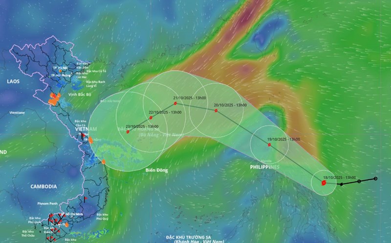
Updated from the National Center for Hydro-Meteorological Forecasting, at 1:00 p.m. on October 19, the center of storm Fengshen was at about 14.7 degrees north latitude; 120.4 degrees east longitude, in the central Philippines. The strongest wind near the storm center is level 9 (75 - 88 km/h), gusting to level 11. The storm is moving northwest at a speed of 20 - 25 km/h.
It is forecasted that in the next 24 hours, the storm will move northwest at a speed of about 25 km/h, entering the East Sea as storm No. 12 and is likely to strengthen. At 1:00 p.m. on October 20, the center of the storm was at about 18.3 degrees north latitude; 116.2 degrees east longitude, in the northern East Sea. Strong wind level 10, gust level 12.
The danger zone is north of latitude 15 degrees north to 20.5 degrees north; east of longitude 114 degrees east. Natural disaster risk level 3 for the northern East Sea area.
It is forecasted that in the next 48 hours, the storm will move westward, at a speed of about 15 km/h and is likely to strengthen. At 1:00 p.m. on October 21, the center of the storm was at about 18.5 degrees north latitude; 113 degrees east longitude, in the northern East Sea, about 200 km north-northeast of the Hoang Sa special zone. Strong wind level 11, gust level 13.
The danger zone is north of the latitude of 16.5 degrees north to 20.5 degrees north; from the longitude of 111 degrees east to 118 degrees east. The natural disaster risk level is level 3 for the northern East Sea area (including Hoang Sa special zone).
It is forecasted that in the next 72 hours, the storm will move southwest, at a speed of 5-10 km/h. At 1:00 p.m. on October 22, the center of the storm was at about 17.6 degrees north latitude; 111.4 degrees east longitude, in the northwest sea of Hoang Sa special zone. Strong wind level 10, gust level 13.
The danger zone is north of latitude 15.5 degrees north to 20 degrees north; from longitude 109.5 degrees east to 115 degrees east. The natural disaster risk level is level 3 for the western sea area of the northern East Sea (including the Hoang Sa special zone).
In the next 72 to 120 hours, the storm will move mainly southwest, traveling about 10 km/h and gradually weakening.
Regarding the impact of the storm, the sea area east of the northern East Sea will have strong winds of level 6 - 7; the area near the storm's eye will have strong winds of level 8 - 10, gusts of level 12, waves 2.5 - 5 m high, very rough seas.
From October 20 to 22, the northern East Sea area (including Hoang Sa special zone) is likely to be affected by strong winds of level 10 - 11, gusting to level 13. All ships operating in the above dangerous areas are likely to be affected by thunderstorms, whirlwinds, strong winds and large waves.