According to the National Center for Hydro-Meteorological Forecasting, floods on the Cau River (Thai Nguyen) at Gia Bay station, Trung River (Lang Son) at Huu Lung station are receding. Floods on the Cau River (Bac Ninh) are rising slowly. Floods on the Thuong River (Bac Ninh) have peaked at 7.6m (at 3:00 a.m. on October 9), above the historical flood level in 1986 of 1.3m and are decreasing.
The water level at 1:00 p.m. on October 9 on the rivers is as follows: On the Cau River at Gia Bay station 26.53m, about 0.47m below alert level 3; at Dap Cau station 7.4m, about 1.1m above alert level 3.
On Thuong River at Cau Son station 18.22m, above alert level 3 2.22m; at Phu Lang Thuong station 7.57m, above alert level 3 1.27m, 0.05m higher than the historical flood in 1986 (7.52m).
On the Trung River at Huu Lung station 23.04m, 0.5m above the historical flood level in 1986 (22.54m).
In the next 12 hours, the flood on the Cau River is likely to peak, the flood peak at the Dap Cau station is about 1.3m above alert level 3. Floods on Thuong River at Phu Lang Thuong Station and on Trung River at Huu Lung Station will continue to decrease and remain above alert level 3. Floods on the Cau River at Gia Bay station continue to drop to alert level 1.
In the next 12 - 24 hours, floods on rivers will continue to decrease; the water level on Cau River at Gia Bay station will be below alert level 1, at Dap Cau station will be above alert level 3. Floods on Thuong River at Cau Son Station, Phu Lang Thuong Station and on Trung River at Huu Lung Station remain above alert level 3.
Warning in the next 24 hours, floods on Luc Nam River (Bac Ninh) at Luc Nam Station, floods on Thai Binh River (Hai Phong) at Pha Lai Station will fluctuate above alert level 1.
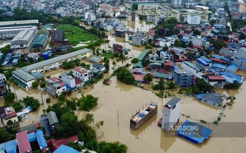
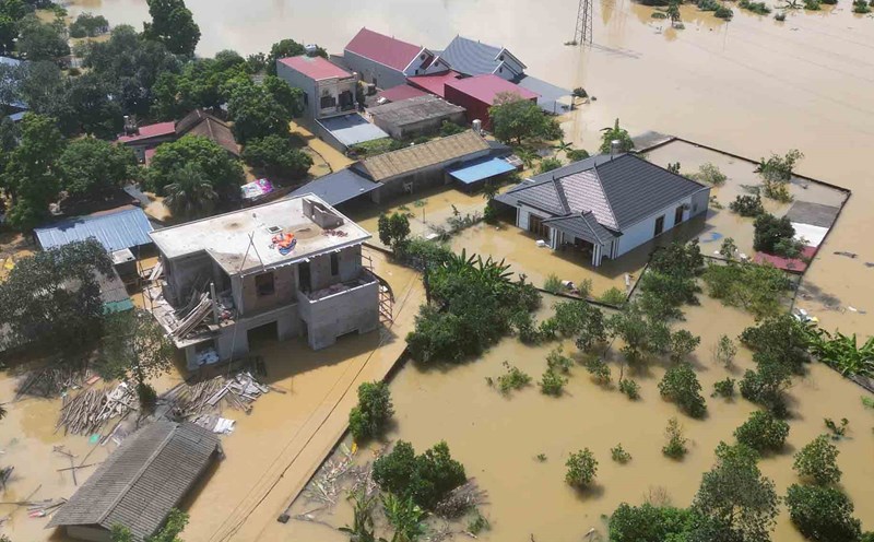
The meteorological agency forecasts widespread flooding in the provinces of Thai Nguyen, Bac Ninh, Lang Son in the next 2-3 days; risk of flooding in low-lying areas along rivers, urban areas in the Northern region. Risk of riverbank, river dike and landslides on steep slopes in the mountainous areas of the North.
Real-time warning information for areas at risk of flash floods and landslides is provided online at: https://luquetsatlo.nchmf.gov.vn and in a separate bulletin warning of flash floods and landslides.
Floods on rivers cause flooding in low-lying areas along rivers, affecting waterway transportation, aquaculture, agricultural production, people's lives and socio-economic activities.
The meteorological agency noted that forecast and warning information is calculated at the expected regulation level of discharge from upstream reservoirs. The Hydrometeorological Agency will update bulletins when there are changes in the discharge flow of reservoirs.