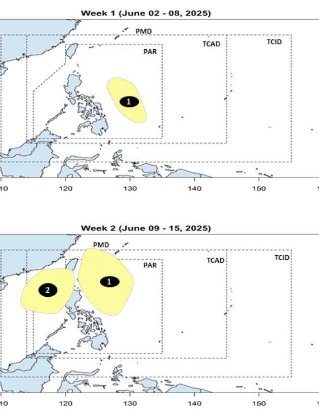
The latest storm and low pressure forecast on June 2 from the Philippine Atmospheric, Geophysical and Astronomical Services Administration (PAGASA) said that 2 low pressure areas around the East Sea will appear in the forecast period from June 2 to June 15.
According to the bulletin, during the week from June 2 to June 8, a low pressure near the East Sea is expected to develop in the Philippine Sea area. The low pressure will form within the Philippine Forecast Area (PAR) with little chance of strengthening into a storm.
However, this low pressure near the East Sea is expected to expand to the affected area near the Philippines during the week of June 9 to June 15. Accordingly, this low pressure will gradually move north of the Philippine Sea during the forecast period and will continue to have little chance of strengthening into a storm.
Also during the week of June 9 to June 15, PAGASA forecasts another low pressure to form near the western Philippines. This low pressure appears in the northern part of the East Sea, with little chance of strengthening into a storm.
According to PAGASA's typhoon forecast, one to two tropical storms are expected to enter the Philippine Forecast Area (PAR) in June.
Citing historical data and climate models, PAGASA weather expert Joanne Mae Adelino said that tropical cyclones in June typically follow one of four directions.
Some storms enter the PAR with the tendency to make landfall in the Philippines, but change direction before making landfall, to head towards Taiwan (China) or Japan. Some other storms entered the PAR but did not approach the Philippine mainland but changed direction to Japan.
PAGASA weather experts also note that some typhoons will make landfall or pass south of Luzon and move across the East Sea to northern Vietnam or Hong Kong (China) or pass through eastern regions to the north of Visayas and the Philippines before heading towards Vietnam or Hong Kong (China).
If one or two tropical storms enter the PAR in June, PAGASA will assign local names to the storm based on the official list for the 2025 typhoon season. The first two names on the list are Auring and Bising.
No tropical storms have entered the PAR since the beginning of the year.
On June 2, PAGASA announced the start of the rainy season in the Philippines. The Philippine State Weather Service issued a notice based on the latest weather analysis and rainfall data from data stations.
"In the past 5 days, scattered to widespread rainfall due to the southwest monsoon has been recorded. This signals the start of the rainy season across the western part of Luzon and the Visayas," the bulletin said.
Philippine weather forecasters also recommend that people take precautions against the impact of the rainy season, southwest monsoon as well as other climate and weather events.


