The latest storm information from the Philippine Atmospheric, Geophysical and Astronomical Services Administration (PAGASA) said that it is expected that 1 to 2 tropical storms will enter the Philippine Forecast Area (PAR) in June.
In the bulletin, PAGASA weather expert Daniel Villamil presented a diagram of the four common paths of typhoons in June. The first two paths are the storm change direction scenario, and the second path is in the storm landfall scenario.
Villamil pointed out that the low pressure area is likely to form in June and strengthen into a storm and approach the Philippine mainland, but is also likely to change direction to the north or northeast, towards the northern border of the PAR, which is near Taiwan (China) and Japan.
"Even when the storm is located far from the Northeast of the Philippines, although not landing, it is still capable of sucking the southwest monsoon. Therefore, although the storm is far away, the rain can still occur all over the country, not directly due to storms, but due to the enhanced southwest monsoon," said Villamil.
Villamil noted that the third and fourth directions for the June storm are landfall scenarios. This means that storms entering the PAR may make landfall in the area east of Southeast Luzon or Eastern Visayas, Philippines.
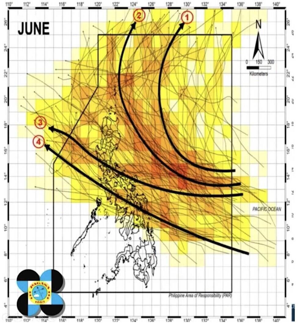
After making landfall, the storm could move across much of the Philippine mainland. When it reaches the West Philippine Sea (ie the East Sea), the storm will continue to move westward, towards Vietnam and Hong Kong (China)" - expert Villamil said.
Previously, on May 30, PAGASA officially announced the beginning of the southwest monsoon season (habagat), signaling that the rainy season is approaching.
If going to PAR in June, Pagasa will name the storm based on the official list for the 2025 storm season. The first two names on the list are Auring and Bising. No tropical storms have entered PAR since the beginning of the year.
According to the Asian Summer Prospect for the Asian Summer Prospect of the National Meteorological Agency of China (CMA), the Beijing Climate Center (BCC) said that during the 2025 storm season, the frequency of storms in the Northwest Pacific and the storm in the East Sea will be close to normal, with the number of storms from 27-29 (while the average index in the period 1991-2020 is 25), with 7-9 tropical storms will land in China.
The 2025 typhoon season is expected to be as strong as expected, or more intense than usual, with a general direction west and northwest.
Meanwhile, the latest typhoon information from the Hong Kong Meteorological Agency (China) said that in the 2025 typhoon season, the names of storms in the northwest Pacific will be added with 3 new names including Bori, Saobien and Tianma. These names are used to replace the old names Doksuri, Saola and Haikui.
The new name for the 2025 typhoon season in this region was approved at the 57th meeting of the Tourism Committee, under the United Nations Economic and Social Committee for Asia-Pacific and the World Meteorological Organization.
Typhoon Bori, which means " major mach," is contributed by South Korea. Typhoon Saobien means a species of starfish, contributed by Vietnam. The name Tianma means horse of heaven, a legendary creature in China, contributed by China.


