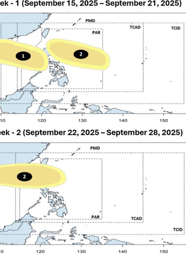
The latest storm and low pressure information on September 15 from the Philippine Atmospheric, Geophysical and Astronomical Services Administration (PAGASA) said that 2 low pressure areas are expected to enter the East Sea by the end of September.
The bulletin stated that during the week from September 15 to 21, 2 low pressure areas are expected to appear around the East Sea. The first low pressure is the low pressure in the East Sea. This low pressure is forecast to head towards Vietnam, with the possibility of strengthening into a low to moderate storm.
The second low pressure is expected to form during the forecast period as a low pressure near the East Sea. The system is expected to appear east of the Philippine Forecast Area (PAR). According to Philippine weather forecasters, this low pressure near the East Sea will gradually move west, reaching Northern Luzon, Philippines. During the week of September 15 to 21, this low pressure is unlikely to strengthen into a storm.
It is expected that during the week of September 22 to September 28, this low pressure will pass through Northern Luzon, entering the East Sea. This low pressure in the East Sea will then move westward, towards Vietnam and southern China. The system is likely to strengthen into a low to moderate storm.
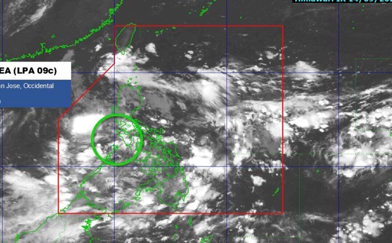
Currently, Philippine weather forecasters are monitoring the low pressure in the 09c East Sea. At 2:00 p.m. on September 15, the low pressure system was 370 km east of Coron, Palawan, Philippines. It is forecasted that this low pressure is unlikely to strengthen into a tropical depression in the next 24 hours.
Regarding the development of storms and tropical depressions in the East Sea, the Hong Kong Meteorological Station (China) recently forecast that a potential storm could appear and affect Hong Kong (China) right after September 17. Strong winds and heavy rain are forecast for this weekend due to the influence of a new storm in the East Sea.
Previously, the Hong Kong Weather Forecast Agency (China) forecasted that 3 low pressure areas are about to form in the East Sea, with at least 2 systems likely to affect the coast of Guangdong province, China.
A low pressure is forecast to move near Hainan Island, China, but the intensity and path of this system are still uncertain.
Another low pressure may form over the northwest Pacific Ocean, east of the Philippines, this weekend. The system is likely to enter the South China Sea, getting closer to Hong Kong (China) on September 18 and September 19, then gradually strengthen.
The third low pressure is forecast to have the strongest intensity, approaching Luzon early next week. However, the path of the depression is still uncertain.