Highest alert for storm No. 5 Kajiki, gusting to level 16, about to make landfall for the first time

Khánh Minh |

Typhoon No. 5 Kajiki is forecast to make landfall or pass near the coast of Hainan (China) on the evening of August 24 before heading towards the coastal areas of Central and Northern Vietnam.

According to the latest typhoon information from the Hong Kong Meteorological Station (China), on the morning of August 24, typhoon No. 5 Kajiki is increasing in strength as it leaves the special zone and moves rapidly towards Hainan Island, China.

At 10:00 a.m. on August 24, the center of the storm was about 630 km south-southwest of Hong Kong (China), moving west at a speed of 18 km/h. Maximum winds near the center of the storm reached 130 km/h.

The Hong Kong Meteorological Administration (China) said it would cancel all storm warning signals as Kajiki no longer threatened the special zone, but warned of heavy rain, thunderstorms and big waves along the coast.

Meanwhile, in Tam A city, Hainan, China, the local meteorological agency has raised the storm warning from orange to red - the highest warning level. In the next 12 hours, the storm will maintain level 12, gusting to level 13-15, with continuous showers and thunderstorms. The authorities urgently announced the closure of schools, suspension of work, suspension of public transportation, maritime activities and tourist attractions.

China's National Flood and Drought Prevention Agency has also activated emergency response measures, sending a working group to Hainan to support flood and storm prevention.

Tau thuyen tro ve dao Hai Nam, Trung Quoc tranh bao so 5, ngay 23.8.2025. Anh: Xinhua
Ship returns to Tam A, Hainan, China to avoid typhoon No. 5 Kajiki, on August 23, 2025. Photo: Xinhua

In Quang Dong, the authorities have launched a level 4 emergency response. It is forecasted that from the evening of August 24 to August 25, heavy rain with strong gusts of wind will sweep across the Loi Chau peninsula and coastal areas of Mau Danh, Duong Giang and Giang Mon.

China applies a four-level emergency response system, with level 1 being the most severe. The weather warning system is also divided into 4 levels: Red (most modest), orange, yellow and green. With Hainan raising to red, this shows that the risk of storm No. 5 Kajiki causing serious impacts is very high.

Meanwhile, the Vietnam National Center for Hydro-Meteorological Forecasting said that storm No. 5 is a relatively special storm, forming right in the East Sea, with very strong intensity, moving fast and a very wide range of impact.

Du bao duong di cua bao so 5. Anh: Trung tam Du bao Khi tuong Thuy van Quoc gia Viet Nam
Forecast of the path of storm No. 5. Photo: Vietnam National Center for Hydro-Meteorological Forecasting

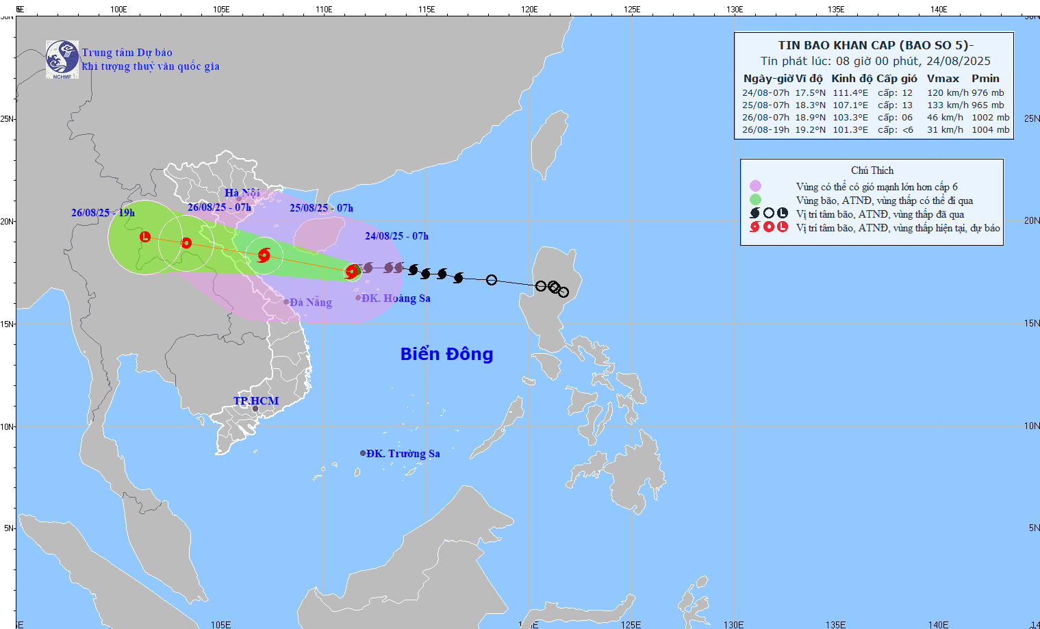
At 10:00 on August 24, the center of the storm was at about 17.4 degrees North latitude; 110.9 degrees East longitude, about 585km from Nghe An, about 560km east of Ha Tinh.

The strongest wind is level 12-13 (118-149km/h), gusting to level 16. It is forecasted that in the next 3 hours, the storm will move westward, at a speed of about 15km/h.

Khánh Minh
RELATED NEWS

Forecast of the next storm Jacinto right after storm No. 5 in the East Sea

|

A low pressure area near the Philippines is being closely monitored as it is likely to become the next storm No. 5 Jacinto in the East Sea.

blind tien tri Vanga's prediction of catastrophic natural disasters

|

One of the most worrying predictions of the blind tien tri Vanga for 2026 is related to extreme natural disasters.

Storm triangle forms, 3 new depressions follow storm Erin

|

Forecasters are monitoring three depressions that could become tropical storms in the coming days following Erin in the Atlantic.

From Ho Chi Minh City to the Capital to wait to see the parade and parade

|

Hanoi - Veterans from many places have arrived in Hanoi to watch the parade to celebrate the 80th anniversary of National Day.

Enrollment time of schools in Ho Chi Minh City

|

HCMC - After announcing the admission scores, schools have begun to welcome students to attend school.

People struggle with traffic jams at the VND3,400 billion intersection project at the gateway to Ho Chi Minh City

|

HCMC - The An Phu intersection project with a total investment of more than VND3,400 billion is slowly constructing, with barriers overflowing onto the road, causing serious congestion in the area.

Hanoi weather forecast: Will the days of parades and parades be affected by storm No. 5?

|

According to the Northern Hydrometeorological Agency, Hanoi's weather forecast is that there will be rain from now until August 26 due to the impact of storm No. 5.

For the third consecutive year, Bao Ha temple in Lao Cai has paid the budget more than 70 billion VND

|

Lao Cai - Bao Ha Temple welcomes millions of visitors to worship and pray for fortune every year, thereby contributing tens of billions of VND to the budget.

Forecast of the next storm Jacinto right after storm No. 5 in the East Sea

Song Minh |

A low pressure area near the Philippines is being closely monitored as it is likely to become the next storm No. 5 Jacinto in the East Sea.

blind tien tri Vanga's prediction of catastrophic natural disasters

Song Minh |

One of the most worrying predictions of the blind tien tri Vanga for 2026 is related to extreme natural disasters.

Storm triangle forms, 3 new depressions follow storm Erin

Song Minh |

Forecasters are monitoring three depressions that could become tropical storms in the coming days following Erin in the Atlantic.