The latest storm/low pressure forecast on June 29 from the Philippine Atmospheric, Geophysical and Astronomical Services Administration (PAGASA) said that a low pressure area is tending to form in the eastern part of the country and is expected to cause scattered thunderstorms in the Visayas and Bicol regions from today.
In the weather bulletin effective until July 4, PAGASA said that the low pressure area may move closer to the Bicol and Eastern Visayas regions on June 29. The interaction between the low pressure and the southwest monsoon will create thick clouds and thunderstorms in the Visayas, Mindanao, Mimaropa, Bicol regions and Quezon province until the end of June 30.
The rest of Luzon will see scattered to cloudy clouds with localized showers during this period.
If it maintains its current direction, the low pressure area is likely to move northwest to the northeastern part of Luzon from July 1 to July 4, bringing widespread thunderstorms in Luzon and the Visayas.
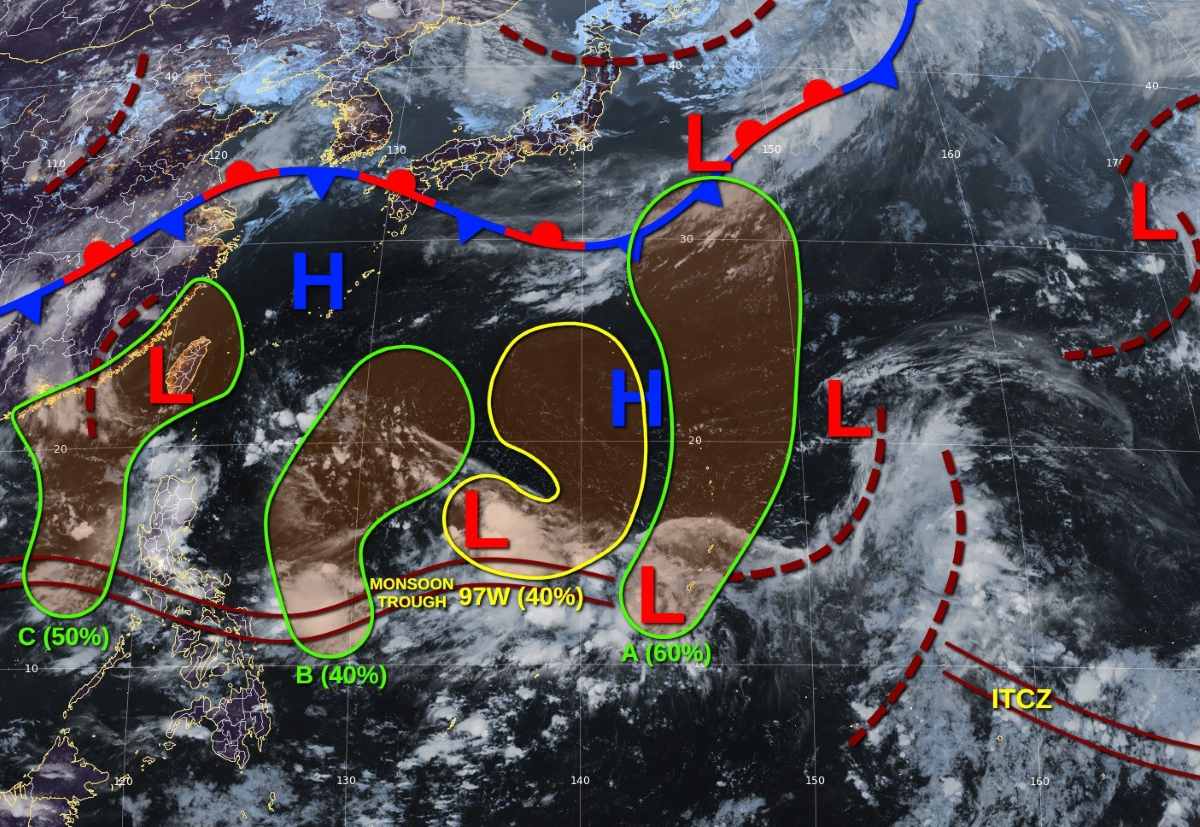
Regarding the low pressure/storm situation in the Northwest Pacific as of June 29, the US Joint Typhoon Warning Center (JTWC) said that there are currently no active tropical cyclones, but there are four atmospheric disturbance areas that need to be monitored.
97W (north of Palau): Thunderstorms are not well organized, but could develop into a tropical depression over the weekend, before being absorbed by another disturbance. The probability of formation is average (40%).
Disturbance A (near Guam): Causing strong thunderstorms, likely to become a low pressure area at the beginning of the week. The probability of formation is average (60%).
Interruption B (east of Samar): A low pressure is forecast to form early in the week, with the possibility of developing into a weak storm. The probability of formation is average (40%).
Intermittent C (northwest Palawan, Philippines): Expected to appear in the middle of next week in the East Sea, with the possibility of developing into a tropical depression in the central East Sea area. The probability of formation is average (50%).
Regarding rain forecast, according to the Vietnam National Center for Hydro-Meteorological Forecasting, from early morning of June 29 to early morning of July 1, the Northern region will have moderate rain, heavy rain and thunderstorms, locally very heavy rain. The common rainfall is 70-140mm, locally over 250mm. Warning of the risk of heavy rain over 100mm in 3 hours
In the late afternoon and evening of June 29, in Thanh Hoa, Nghe An, Central Highlands and the South, there will be scattered showers and thunderstorms, locally heavy rain (10-30mm, locally over 50mm)
From early morning of July 1 to early morning of July 2, the Northern region will have moderate rain, heavy rain, locally very heavy rain and thunderstorms. The common rainfall is 30-70mm, in some places over 150mm.
Heavy rain in the Northern region is likely to last until around July 2. The total rainfall for the entire period (from early morning of June 29 to July 2) was generally 100-300mm, locally over 500mm.
During thunderstorms, tornadoes, lightning, hail and strong gusts of wind may occur. Warning level of natural disaster risk due to heavy rain: Level 1
Risk of flooding in low-lying areas, urban areas, industrial parks. Risk of flash floods on small rivers and streams. Landslides on steep slopes and hills.


