Storm Krovanh maintains strong intensity, forecast to change direction in the next 48 hours

Châu Anh |

Typhoon Krovanh still maintains winds of 65 km/h and is expected to re-enter the Philippine Forecast Area in the morning or early afternoon of September 6.

According to the latest storm and low pressure news from the Philippine Atmospheric, Geophysical and Astronomical Services Administration (PAGASA), tropical storm Krovanh, formerly known locally as Pilandok, is being monitored outside the Philippine Area of Responsibility (PAR) and is expected to re-enter the area during the day.

According to updates at 2:00 AM on September 6, PAGASA said tropical storm Krovanh is still outside PAR. The previous system was locally named Pilandok, after leaving PAR it was called internationally Krovanh.

In the bulletin at 10:00 PM on September 5th, the center of Typhoon Krovanh was identified as about 835km northeast of the northern tip of Luzon Island. The storm is moving southeast at a speed of about 20 km/h, the strongest wind near the center of the storm reaches 65 km/h, gusting up to 80 km/h.
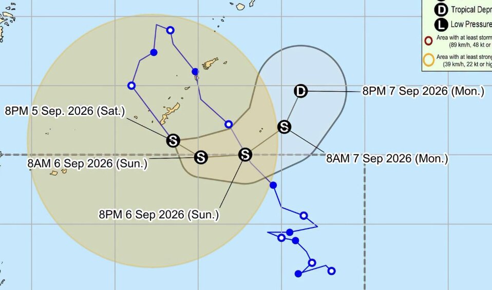
Dự báo đường đi và cường độ của bão Krovanh từ ngày 5-7.9. Ảnh: PAGASA
Forecast of the path and intensity of storm Krovanh from September 5-7. Photo: PAGASA

PAGASA said that Typhoon Krovanh will continue to move southeast and is forecast to rejoin PAR in the morning to early afternoon of September 6. When returning to PAR, the storm will be called by the local name Pilandok.

According to PAGASA, Krovanh may continue to maintain intensity for about 36 hours before weakening into a tropical depression in the afternoon or evening of September 7.

Previously, PAGASA assessed that Krovanh had a low chance of landing on the Philippines or going deeper inland.

However, the system can still indirectly affect sea conditions through the southwest monsoon (Habagat). In the next 24 hours, Habagat may cause moderate to strong rough seas in the coastal waters of Batanes and the Babuyan Islands. The sea areas east and west of Luzon Island are also forecast to have moderate rough seas.

PAGASA recommends that people continue to update information about the storm's developments, and proactively prevent heavy rain, strong winds and rough seas in affected areas.

Châu Anh
RELATED NEWS

Typhoon Pilandok unexpectedly reappears, warning of prolonged heavy rain

|

Typhoon Pilandok is expected to return to the Philippines' monitoring area and may continue to strengthen the southwest monsoon, causing rain in many areas.

Forecast of storms and monsoons operating in rapid succession near the East Sea, which may affect Vietnam

|

September is forecast to continue to have storms and active tropical cyclones, in which some systems are likely to head towards the East Sea and affect Vietnam.

New storms continuously bend direction at sea, unusually winding path

|

Typhoon Pilandok is accelerating northwest but is about to change direction, creating an unusual path.

Overcoming landslides on DT 745B road causing inter-provincial road separation in Dong Nai

|

Dong Nai - After many consecutive days of rain, the 5-tree slope section of DT 755B road was seriously landslide.

Nepalese grandmother miraculously survives after 10 days buried in mud

|

A 64-year-old woman in Nepal was successfully rescued after 10 days of being trapped by a landslide, in the context of thousands of people still losing contact.

The journey from teacher to crown of the newly crowned Miss World in Nha Trang

|

Miss Dominican Republic - Joheirry Mola Dominguez attracted attention when she from a teacher, model and community activist became the reigning Miss World 2026.

Lottery ticket seller teacher opens free class for poor children in Ho Chi Minh City

|

Ho Chi Minh City - On the evening of September 5, Ms. Nguyen Thi Ba's charity class held its opening ceremony, entering the new school year in a simple and warm atmosphere.

Typhoon Pilandok unexpectedly reappears, warning of prolonged heavy rain

Châu Anh |

Typhoon Pilandok is expected to return to the Philippines' monitoring area and may continue to strengthen the southwest monsoon, causing rain in many areas.

Forecast of storms and monsoons operating in rapid succession near the East Sea, which may affect Vietnam

Châu Anh |

September is forecast to continue to have storms and active tropical cyclones, in which some systems are likely to head towards the East Sea and affect Vietnam.

New storms continuously bend direction at sea, unusually winding path

Châu Anh |

Typhoon Pilandok is accelerating northwest but is about to change direction, creating an unusual path.