Many strong whirlpools appear, possibility of new storms in the next 2 weeks

Châu Anh |

On September 1, low pressure Pilandok officially strengthened into a tropical storm, warning of 4 more monsoon zones likely to form in the next 2 weeks.

According to the latest weather forecast from the Philippine Atmospheric, Geophysical and Astronomical Services Administration (PAGASA), up to 4 weather disturbances may form or enter PAGASA's Monitoring Area (PMD) in the period from September 1 to 14.

PAGASA assesses the possibility of a tropical cyclone appearing at a noteworthy level in the first week and is still likely to continue in the second week.

From July 1 to 7, PAGASA forecasts a vortex with characteristics similar to a tropical cyclone (TCLV) likely to form in the east of the Tropical Cyclone Warning Area (TCAD), denoted as TCLV1.

According to the forecast map, TCLV1 zone is outside the Philippine Area of Responsibility (PAR) and is forecast to move towards Japan. The possibility of this vortex developing into a storm in the first week is assessed from low to medium.

During the same period, Typhoon Saudel is still outside PAR and is forecast to be likely to return to the northwest PAR area.
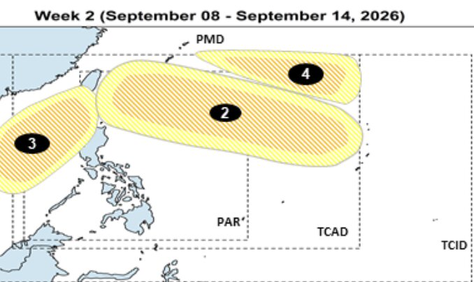
Dự báo các vùng xoáy có khả năng hình thành từ ngày 8-14.9. Các vùng 2, 3 và 4 có khả năng phát triển thành xoáy thuận nhiệt đới ở mức thấp đến trung bình. Ảnh: PAGASA
Forecast of ridges likely to form from September 8-14. Regions 2, 3 and 4 are likely to develop into tropical cyclones at a low to moderate level. Photo: PAGASA

From September 8-14, PAGASA forecasts 3 more TCLV whirlpools, numbered 2, 3 and 4 on the map.

TCLV2 is likely to form in the east of TCAD and is forecast to potentially enter the northeastern PAR area.

TCLV3 is forecast to form near the western boundary of PMD, then likely to move into PAR.

Meanwhile, TCLV4 is forecast to form in the northeastern PMD area, then it is likely to shift direction to southern Japan.

PAGASA assesses the possibility of all 3 TCLV regions developing into tropical cyclones at a low to medium level.

If new systems form and enter PAR, Queenie and Rosal will be the next two names on the Philippine hurricane naming list.

Tropical depression Pilandok has strengthened into a storm
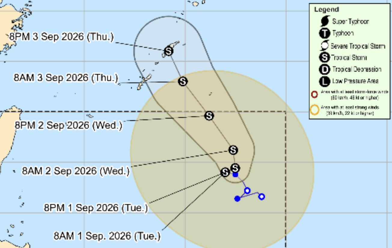
Dự báo đường đi và cường độ của bão Pilandok từ ngày 1.9-3.9. Ảnh: PAGASA
Forecast of the path and intensity of Typhoon Pilandok from September 1st to 3rd. Photo: PAGASA

Depression Pilandok has strengthened into a tropical storm on the morning of September 1st and is currently in PAR.

According to the bulletin at 11:00 AM on September 1st, Pilandok has maximum sustained winds of 65 km/h, gusts of 80 km/h, with the storm's center about 1,060km east of the northernmost point of Luzon Island.

PAGASA forecasts Pilandok will move slowly in a northwest to northwest direction, then leave PAR on the evening of September 2 or early morning of September 3 and head south of Japan.

This agency assessed that the possibility of Pilandok landing or directly affecting the Philippines is currently low.

Châu Anh
RELATED NEWS

New low pressure rapidly intensifies into storm, continuously changing direction at sea

|

Depression Pilandok is forecast to strengthen into a storm in the next 12 hours and may head south of Japan.

Forecast of the path of the tropical depression, likely to strengthen into a storm soon

|

Tropical depression Pilandok is moving slowly over the Philippine Sea and may strengthen into a storm in the afternoon of September 1 before leaving the Philippine forecast area.

New low pressure officially formed, strengthening rapidly beyond expectations

|

The low pressure area 08j has officially strengthened, named Pilandok, and is currently operating in the Philippine Sea.

Many strong whirlpools appear, possibility of new storms in the next 2 weeks

|

On September 1, low pressure Pilandok officially strengthened into a tropical storm, warning of 4 more monsoon zones likely to form in the next 2 weeks.

Birds suddenly run amidst traffic on National Highway 18 in Quang Ninh

|

Quang Ninh - A ostrich suddenly ran amidst traffic on National Highway 18, traffic police promptly warned and regulated vehicles to ensure safety.

Current status of the nearly 4.6km long riverside road passing through the super ward in Dong Nai

|

Dong Nai - The Cai riverside road project is nearly 4.6km long, passing through Tran Bien and Tam Hiep wards, with a total investment of nearly 574 billion VND.

New low pressure rapidly intensifies into storm, continuously changing direction at sea

Châu Anh |

Depression Pilandok is forecast to strengthen into a storm in the next 12 hours and may head south of Japan.

Forecast of the path of the tropical depression, likely to strengthen into a storm soon

Châu Anh |

Tropical depression Pilandok is moving slowly over the Philippine Sea and may strengthen into a storm in the afternoon of September 1 before leaving the Philippine forecast area.

New low pressure officially formed, strengthening rapidly beyond expectations

Châu Anh |

The low pressure area 08j has officially strengthened, named Pilandok, and is currently operating in the Philippine Sea.
