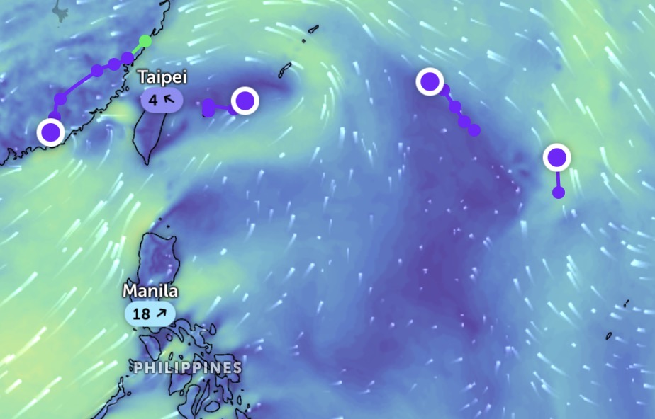
The latest storm and low pressure information on the afternoon of July 10 from the Philippine Atmospheric, Geophysical and Astronomical Services Administration (PAGASA) said that 3 low pressure areas formed inside and outside the Philippine Forecast Area (PAR).
PASA said the first low pressure near the East Sea was identified as LPA 07c. This low pressure is inside the PAR and is unlikely to strengthen into a tropical depression in the next 24 hours. Currently, the low pressure area near the East Sea LPA 07c is 790 km northeast of Itbayat, Batanes, Philippines.
Meanwhile, two other depressions are forming outside the PAR. PAGASA noted that low pressure LPA 07d has a "moderate chance" of becoming a tropical depression within the next 24 hours. LPA 07d is 2,070 km east of Northern Luzon, Philippines.
The third depression is the remnant of tropical depression Today (called Bising in the Philippines), which is 475 km northwest of Itbayat, Batanes. This system is unlikely to strengthen into a tropical depression within the next 24 hours.
The US Navy's Joint Typhoon Warning Center (JTWC) recorded up to 4 low pressure areas operating in the northwest Pacific Ocean. The four depressions are: Remnants of storm today, low pressure Invest 92W near Japan's Miyako Islands, low pressure 91W south of Japan, low pressure 93W south of Japan. Both of these four depressions are unlikely to strengthen into a typhoon in the next 24 hours.
According to PAGASA weather forecasters, the southwest monsoon will continue to cause rain in many areas of the Philippines. Rain is forecast in Metro Manila, Batanes, Babuyan Islands, Zambales, Bataan, Cavite, Occidental Mindoro and Antique.
Meanwhile, cloudy skies with scattered rains and thunderstorms may appear in locos, Cordillera, Negros Peninsula, Zamboanga Peninsula, Barmm, Soccsksargen, the rest of Mimaropa, Western Visayas, mainland Cagayan, tarlac, Nueva Ecija, Pampanga, Bulacan, Batangas, Rizal, Laguna and Davao Occidental. The remaining areas of the Philippines are forecast to have cloudy to cloudy skies, accompanied by scattered showers or thunderstorms. PAGASA also warned of flooding and landslides in low-lying areas due to rain.
The Philippine State Weather Agency forecasts that at least two more storms will form or enter the PAR in July. Typhoons in July in the Philippines usually have 3 common moving directions. First, the storm approaches the Philippines but does not make landfall but loops north of the PAR, moving towards Taiwan (China) or Japan.
Second, the typhoon makes landfall in the northernmost islands of the Philippines, moving towards China or Hong Kong (China). Third, the storm makes landfall in the Philippines in the northern or central part of Luzon, then enters the East Sea and heads towards Vietnam.
From now until the end of the year, it is forecasted that 10 to 18 storms will affect the Philippines. However, forecasters say that this year's storm will not be as strong as the 2024 storm season. The next three names for the 2025 hurricane season are Crising, Dante, Emong.