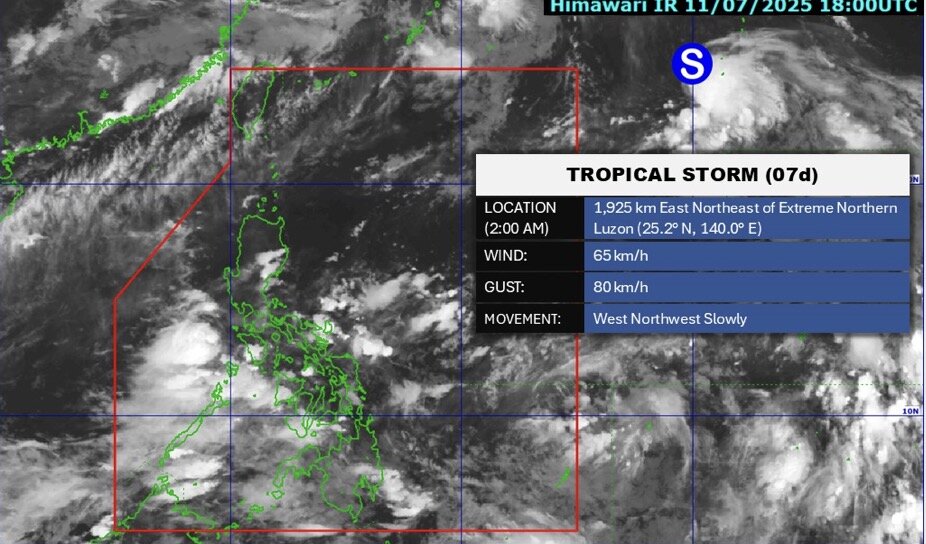
According to the latest storm and low pressure information on the morning of July 12 from the Philippine Atmospheric, Geophysical and Astronomical Services Administration (PAGASA), low pressure area 07d is being monitored outside the Philippine Forecast Area (PAR) and strengthened into a tropical depression on the afternoon of July 11. By 2:00 a.m. on July 12, tropical depression 07d had strengthened into a tropical storm outside the PAR.
The latest storm near the South China Sea is located 1,925 km east-northeast of the northernmost tip of Luzon, Philippines. The system has winds of 65 km/h and gusts of 80 km/h, moving slowly west-northwest.
Meanwhile, another low pressure, the remnants of storm today (called Bising in the Philippines) disappeared on the night of July 11.
In the weather forecast for July 12, PAGASA said that the southwest monsoon or habagat is forecast to affect the Philippines.
Scattered rain is forecast in Western Visayas, Negros Island, Palawan and Occidental Mindoro. Flash floods or landslides can occur due to moderate to heavy rain.
Cloudy weather with scattered showers and thunderstorms is possible in Metro Manila, Mindanao, Visayas, Batanes, Babuyan Islands, Zambales, Bataan, Cavite and Batangas. Flash floods or landslides can occur in moderate to heavy rains.
Cloudy to cloudy skies are forecast with scattered showers or thunderstorms in the remaining islands of Luzon. Flash floods or landslides can occur in severe thunderstorms.
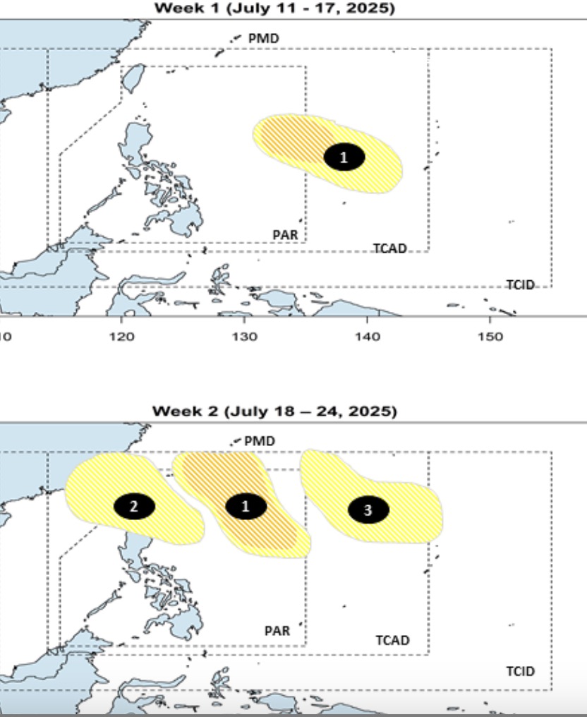
The latest storm and low pressure forecast on July 11 from PAGASA said that there are 3 low pressure areas near the East Sea that have appeared consecutively, including low pressure areas that are likely to strengthen into storms.
PAGASA's forecast clearly states that during the week from July 11 to July 17, no low pressure will form within the Philippine Forecast Area (PAR).
However, Philippine typhoon and low pressure forecasters see a low pressure area appearing at the eastern boundary of PAR and the TCAD forecast area. This low pressure is likely to strengthen into a low to moderate storm.
This low pressure near the East Sea continues to expand to the week of July 18 to 24. The low pressure is forecast to move northwest, when entering the PAR, the low pressure is likely to strengthen into a low to moderate storm.
Also this week, a second low pressure near the East Sea will form east of Northern Luzon, Philippines and will move towards the northernmost tip of Luzon and is unlikely to strengthen into a storm. Notably, this low pressure is likely to enter the northern part of the East Sea.
During the forecast period, a third low pressure near the East Sea will appear northeast of PAGASA's TCAD forecast area. The third depression is unlikely to strengthen into a storm during the week of July 18 to 24.