Typhoon Podul is about to reach its peak intensity, heading straight to the first landfall area

Thanh Hà |

Typhoon Podul, known in the Philippines as Gorio, is on track to strengthen into a typhoon and is forecast to make landfall twice.

The latest storm information from the Philippine Atmospheric, Geophysical and Astronomical Services Administration (PAGASA) at noon on August 11 said that Typhoon Podul is expected to strengthen into a typhoon in the next 12 hours.

The storm, entered the Philippine Forecast Area (PAR) on the night of August 10 and is continuing to move westward over the Philippine Sea.

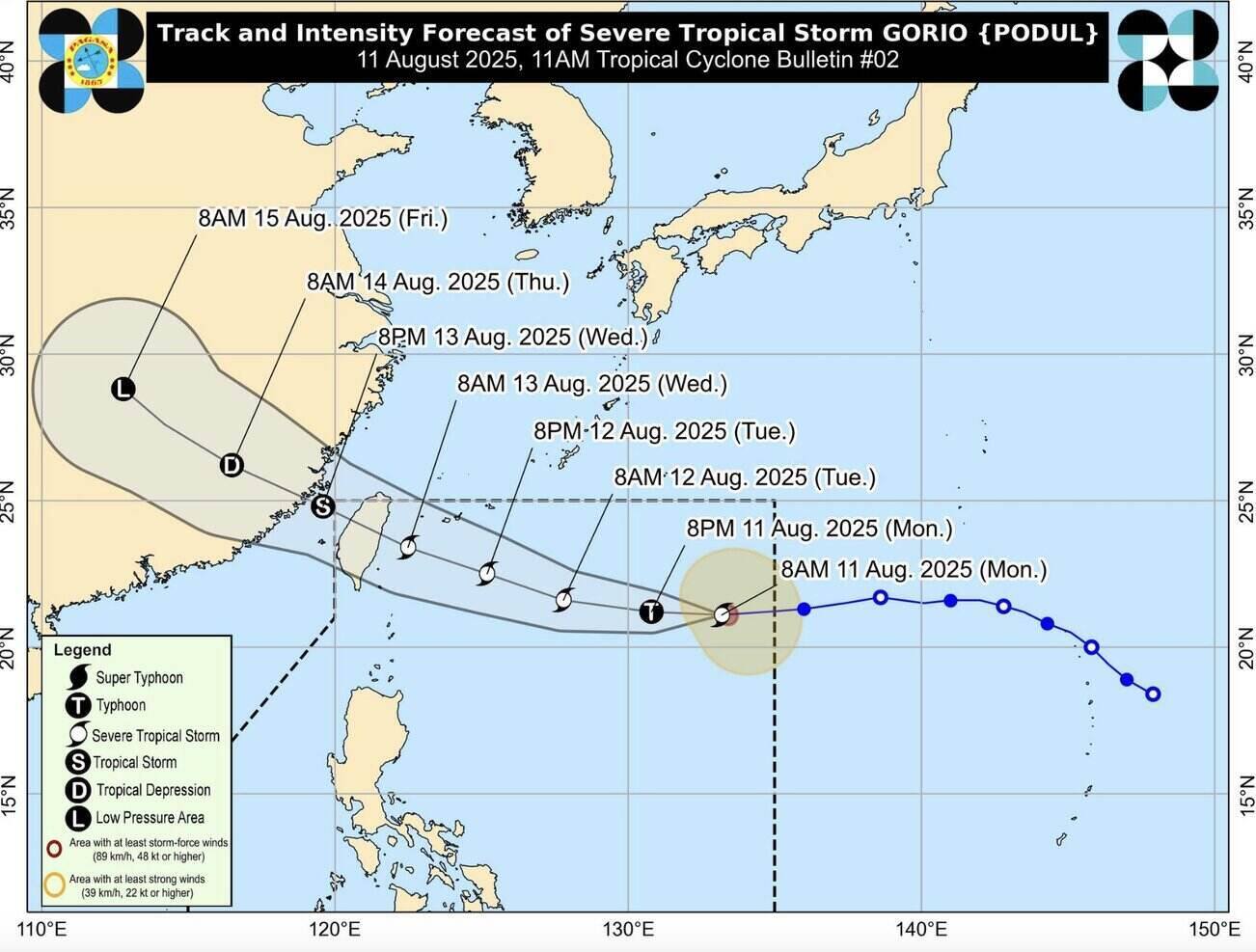
As of 11 a.m. on August 11, the center of the storm is estimated to be 1,180 km east of Northern Luzon, with maximum sustained winds of 110 km/h near the center and gusts of up to 135 km/h. Typhoon Podul is moving west at a speed of 25 km/h.

PAGASA forecasters said that Typhoon Podul is likely to maintain its westerly path for the next 24 hours before gradually turning west-northwest from the afternoon of August 12 to August 14.

Typhoon Podul is expected to reach its strongest intensity on August 12, possibly making landfall on the northeastern coast of Taiwan (China) on August 13 and leaving the Philippine PAR forecast area on the evening of August 13 or the morning of August 14.

PAGASA said that Typhoon Podul is unlikely to directly affect the weather in the Philippines in the next 3 days, but some areas on Luzon may have rain due to the southwest monsoon or habagat.

Manila urban area, Ilocos, Zambales, Bataan, Cavite, Batangas, Occidental Mindoro, Palawan, Batanes and Babuyan Islands may experience cloudy skies, accompanied by scattered showers or thunderstorms due to the influence of the southwest monsoon. The rest of the Philippines may experience cloudy skies, accompanied by scattered showers or thunderstorms.

Duong di du bao cua bao Podul. Anh: PAGASA
Forecast track of Typhoon Podul. Photo: PAGASA

The latest typhoon information from the Taiwan Meteorological Administration (CWA) said that a warning for Typhoon Podul on land may be issued around noon on August 12 after a sea warning may be issued on the night of August 11 or early morning of August 12 when Typhoon Podul approaches Taiwan (China).

Taiwanese typhoon forecasters said the typhoon will bring strong winds and heavy rain when it makes landfall in Hualien and Taitung districts of the island on August 13.

Eastern Taiwan (China) will begin to feel the outward circulation of Typhoon Podul on the evening of August 12, with winds and rain intensifying on August 13.

According to the forecast, Typhoon Podul will leave Taiwan (China) on the evening of August 13 and head straight to mainland China.

Extreme rain (at least 200mm for 24 hours or 100mm for 3 hours) is expected in Nghi Lan district, Hualien district and Taitung district, as well as in mountainous areas south of Taiwan (China).

The weather on August 11 and 12 will be mainly thunderstorms in the afternoon, with the possibility of heavy rain in the Taipei - Tainan - Keelung urban area and mountainous areas north of Taiwan (China).

Independent meteorologist Wu De-rong said that the path of Typhoon Podul has shifted south, with more than 80% chance of the storm's circulation affecting Taiwan (China). He said the storm is likely to maintain its maximum intensity before making landfall and will only weaken after reaching sea.

Thanh Hà
RELATED NEWS

New low pressure has potential to become the strongest storm since the beginning of Erin season

|

The low pressure off the coast of West Africa is being monitored and is likely to strengthen into Hurricane Erin.

Forecast of major storms, super storms in the acceleration phase

|

The storm season is forecast to explode with 9 storms, major storms, and super storms that may appear from now until the end of November.

Typhoon Podul intensifies, changes direction unexpectedly, forecasts another landfall location far from the start

|

Typhoon Podul - the latest storm near the South China Sea - has strengthened and changed direction unexpectedly, with a different expected landfall location from the original.

"Marching forward with Vietnam": Spreading unprecedented values

|

On the afternoon of August 11, Nhan Dan Newspaper in coordination with the Ministry of Public Security held a press conference to announce the national walking activity "Marching forward with Vietnam" to celebrate the 80th anniversary of the August Revolution (August 19, 1945 - August 19, 2025), National Day September 2 (September 2, 1945 - September 2, 2025) and Traditional Day of the People's Public Security (August 19, 1945 - August 19, 2025).

Life in apartment building 176 Dinh Cong after the incident of a man assaulting a woman

|

Hanoi - The incident of Dang Chi Thanh assaulting a woman in the lobby of an apartment building has made people here bat content, and changed community life.

Van Don Special Zone requires inspection and control of smuggled yellow oysters

|

Quang Ninh - The People's Committee of Van Don Special Zone has just issued an official dispatch requesting to strengthen inspection and handling of smuggling and mixing of oysters, especially yellow oysters.

4.4 million cars cannot pass toll stations: Vehicle owners simultaneously upgrade accounts

|

Many car owners simultaneously upgraded their non-stop toll collection accounts after the news that 4.4 million cars were at risk of not being allowed to pass through the non-stop toll station.

New low pressure has potential to become the strongest storm since the beginning of Erin season

Thanh Hà |

The low pressure off the coast of West Africa is being monitored and is likely to strengthen into Hurricane Erin.

Forecast of major storms, super storms in the acceleration phase

Thanh Hà |

The storm season is forecast to explode with 9 storms, major storms, and super storms that may appear from now until the end of November.

Typhoon Podul intensifies, changes direction unexpectedly, forecasts another landfall location far from the start

Thanh Hà |

Typhoon Podul - the latest storm near the South China Sea - has strengthened and changed direction unexpectedly, with a different expected landfall location from the original.