The storm forecast bulletin of the Philippine Atmospheric, Geophysical and Astronomical Services Administration (PAGASA) said that at 1:00 p.m. on July 17, the center of tropical depression Crising was at about 15.1 degrees north latitude, 126.9 degrees east longitude, in the sea east of the Philippines.
The strongest wind near the center of the tropical depression is level 7 (50-61 km/h), gusting to level 9. The central pressure is 1000 hPa. Strong winds extend outward up to 350 km from the center of the tropical depression. Crising is moving west-northwest at a speed of 15-20 km/h.
The Vietnam National Center for Hydro-Meteorological Forecasting said that by 1:00 p.m. on July 18, the center of the tropical depression is forecast to be at 17.4 degrees north latitude, 123.5 degrees east longitude, in the sea east of Luzon Island, Philippines. Intensity level 8-9, gust level 11, likely to strengthen into a storm.
By 1:00 p.m. on July 19, the storm moved west-northwest at a speed of 20-25 km/h. Location of the storm's eye: 18.8 degrees north latitude, 119.1 degrees east longitude, in the sea east of the North East Sea. Intensity: level 10, gust level 12.
Dangerous areas at sea ( strong winds from level 6 and above): From 16.5-21.0 degrees north latitude and from 117.5-120.0 degrees east longitude. Natural disaster risk level: Level 3 (the northeastern sea area of the East Sea).
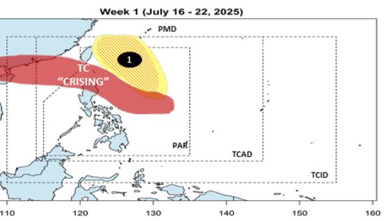
PAGASA's typhoon bulletin said that immediately after Crising, at least two other depressions are likely to develop into typhoons in the next two weeks. During the week of July 16-22, in addition to Crising, low pressure 1 is expected to form in the Philippine Forecast Area (PAR) in the north of Luzon Island. The low pressure is expected to move north, with a moderate chance of strengthening into a storm.
During the week of July 23-29, low pressure 1 will continue to move towards Taiwan (China) - Ryukyu Islands (Japan). Although the possibility of storm formation is moderate to low, this area still needs to be vigilant because the system can develop rapidly when approaching the mainland or encountering favorable atmospheric conditions.
Also during the week of July 23-29, a second low pressure is expected to form northeast of the Philippine Forecast Area (PAR).
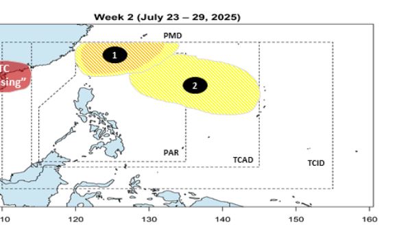
Currently, the possibility of the low pressure 2 strengthening into a storm is still underestimated, but PAGASA has not ruled out the scenario of rapid fluctuations in this system.