Storm Crising is about to form, the East Sea is preparing to welcome consecutive low pressure

Song Minh |

According to the latest storm news on July 16, the low pressure in the Philippine Sea is likely to strengthen into storm Crising in the next 24 hours.

The storm forecast bulletin of the Philippine Atmospheric, Geophysical and Astronomical Services Administration said that at 3:00 a.m. on July 16, the center of low pressure 07f was at about 13.9 degrees north latitude, 133.2 degrees east longitude, 975km east of Southeast Luzon.

The low pressure is located entirely within the Philippine Forecast Area (PAR) and is likely to develop into a storm within the next 24 hours. The storm will then be locally named Crising.

PAGASA forecasts that the potential storm will move northwest over the Philippine Sea. The storm is likely to make landfall in the Northernmost Luzon region late Friday, July 18 or early Saturday morning, July 19.

The southwest monsoon may begin to strengthen today, with heavy rains due to the monsoon expected to make landfall in Southern Luzon and the Visayas.

The southwest monsoon may expand to the areas west of Calabarzon and Central Luzon on July 18, as the storm's rains may also begin to affect Northern Luzon.

Heavy to very heavy rains are possible in Palawan, Occidental Mindoro, Antique and Occidental Mindoro on July 17 and 18.

Floods and mudslides are likely to occur in many areas during heavy and prolonged rains.

According to the Typhoon page on the Northwest Pacific, in the next 10-15 days, with the strong activity of the tropical convergence zone with an axis passing through the East Sea and crossing the sea east of the Philippines and the Northwest Pacific, many disturbances, low pressure areas will be produced and are likely to develop into tropical cyclones.

Dien bien ap thap, bao gan Bien Dong va Tay Bac Thai Binh Duong du kien phuc tap. Anh: Windy.com
The development of low pressure and storms near the East Sea and the Northwest Pacific is expected to be complicated. Photo: Windy.com

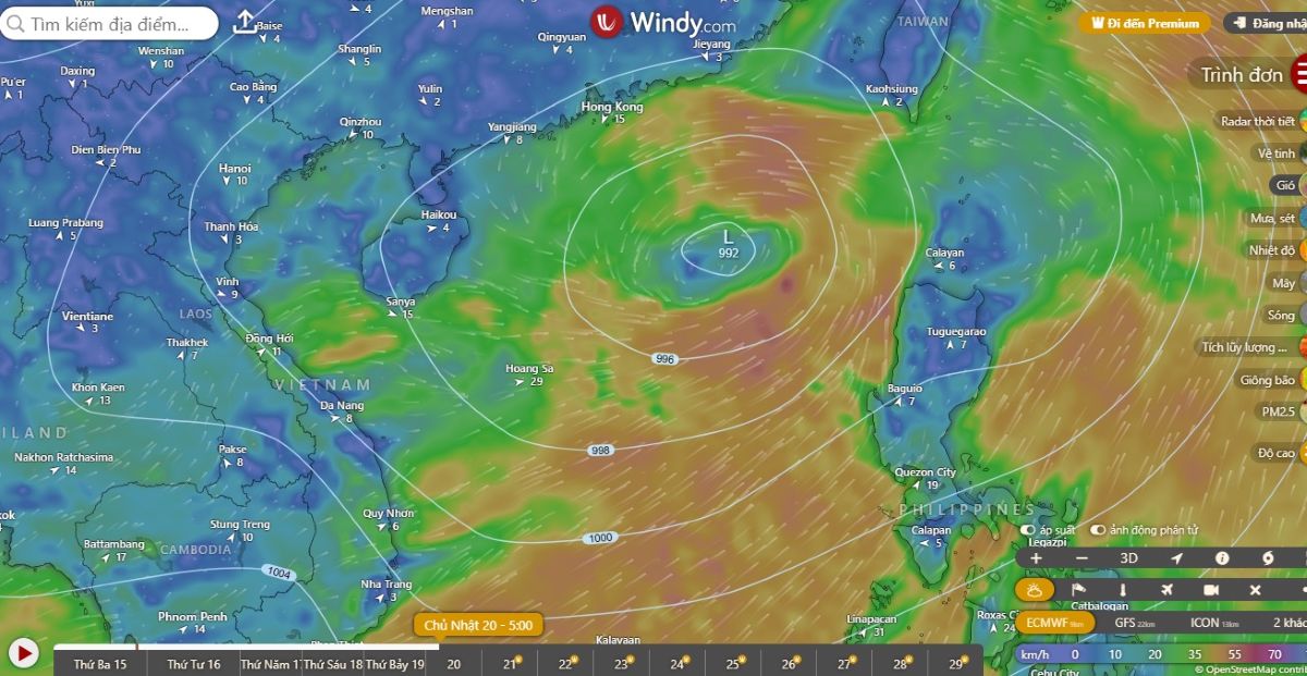
At least 3-4 named storms will be in the Northwest Pacific typhoon center from now until the end of July, of which in the next 2-3 days, the storm in the eastern Philippines is likely to move into the East Sea this weekend.

Due to many factors, especially tropical cyclones operating in the eastern Philippines and mainly Taiwan (China), the storm in the East Sea is expected to have extremely unpredictable and complicated developments in intensity and direction of movement.

The weather forecast at 3:30 a.m. on July 16 of the Vietnam National Center for Hydro-Meteorological Forecasting said that on the day and night of July 16, the mountainous areas of the North will have scattered showers and thunderstorms, with some places having heavy rain. The common rainfall is 15-30mm, locally over 70mm. Thunderstorms will be concentrated in the late afternoon and night.

In the afternoon and evening of July 16, the Central and Southern highlands will have scattered showers and thunderstorms. The common rainfall is 10-30mm, locally over 60mm.

Natural disasters include: tornadoes, lightning, hail and strong gusts of wind in thunderstorms. Risk of flash floods on small rivers and streams; landslides on steep slopes; flooding in low-lying areas.

Song Minh
RELATED NEWS

Tropical depression appears near the Philippines, the East Sea may welcome a storm this week

|

The low pressure near the Philippines strengthened into a tropical depression on July 14, with the potential to strengthen into a storm in the East Sea.

Forecast of the focus of heavy rain when low pressure strengthens this week

|

Florida (USA) is about to enter many days of heavy rain as a weak low pressure area forms and moves through this peninsula.

New low pressure forecast from July 15, storm No. 4 awaits its name

|

The new low pressure is forecast to form from July 15 and if it strengthens, it could become Hurricane Dexter, the fourth storm of the 2025 Atlantic hurricane season.

Hanoi Chairman Vu Dai Thang: Accelerate metro lines, reduce private cars

|

Hanoi - Chairman of the City People's Committee Vu Dai Thang said that the city will accelerate ring roads, strongly develop the urban railway system, and reduce personal vehicles.

Mr. Nguyen Dinh Khang becomes Standing Deputy Minister of Ethnic Minorities and Religious Affairs

|

Mr. Nguyen Dinh Khang resigned from the position of Chairman of the Vietnam General Confederation of Labor to take on a new job, holding the position of Standing Deputy Minister of Ethnic Minorities and Religious Affairs.

Iran fires missiles at 8 countries with important US military bases

|

A series of missiles and drones from Iran have aimed directly at US and Israeli military bases, pushing the entire region into a comprehensive security crisis.

Sand pirates rampant on the Gianh River: Police expand investigation and handle related subjects

|

Quang Tri - After Lao Dong Newspaper's reflection on the rampant sand pirates on the Gianh River, the Police have expanded the investigation and handled related subjects.

Quyet Chien and Thanh Tu help Vietnamese billiards win the world 3-band team carom championship

|

Players Tran Quyet Chien and Nguyen Tran Thanh Tu played effectively to overcome the home team Germany in the final.

Tropical depression appears near the Philippines, the East Sea may welcome a storm this week

Song Minh |

The low pressure near the Philippines strengthened into a tropical depression on July 14, with the potential to strengthen into a storm in the East Sea.

Forecast of the focus of heavy rain when low pressure strengthens this week

Song Minh |

Florida (USA) is about to enter many days of heavy rain as a weak low pressure area forms and moves through this peninsula.

New low pressure forecast from July 15, storm No. 4 awaits its name

Song Minh |

The new low pressure is forecast to form from July 15 and if it strengthens, it could become Hurricane Dexter, the fourth storm of the 2025 Atlantic hurricane season.