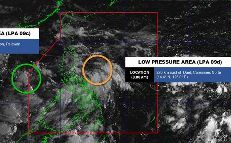
The Philippine Atmospheric, Geophysical and Astronomical Services Administration (PAGASA) said that at 2:00 p.m. on September 16, the low pressure in the sea east of Luzon Island strengthened into a tropical depression and was named Mirasol.
It is forecasted that in the next 24 hours, the tropical depression will move in the West Northwest direction, traveling about 10km per hour.
Due to the influence of the tropical depression circulation, in the central East Sea, there will be showers and thunderstorms, the wind will gradually increase to level 5, sometimes level 6, gusting to level 8. Waves are 2.0-3.0m high, rough seas.
Also according to PAGASA's storm/low pressure forecast, during the week of September 16-22, the second low pressure will appear near the eastern part of Luzon Island and will move towards the Northern Luzon - Taiwan (China). The possibility of this low pressure strengthening into a storm is quite high.
In addition, a third disturbance is likely to form between the eastern edge of the PAR and the tropical cyclone monitoring area (TCAD). The area could enter the PAR, with a low to moderate probability of developing into a typhoon.
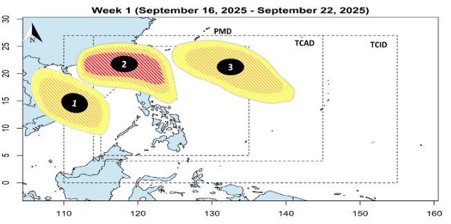
Entering the second week from September 23-29, low pressure 2 will continue to move towards Hainan Island (China) and the Gulf of Tonkin (Vietnam), with a high possibility of becoming a storm.
Low pressure 3 is expected to move north of Luzon - Taiwan (China), with a moderate chance of strengthening into a storm.
At the same time, a fourth disturbance may form east of the PAR, but the probability of developing into a storm is quite low.
With the consecutive appearance of many disturbances/low pressure areas, the risk of storm formation in the East Sea and the Philippine Sea from now until the end of September is assessed at a significant level.
Meteorological agencies recommend that people and authorities of countries in the region, especially the Philippines, Taiwan (China), mainland China and Vietnam, closely monitor storm forecasts and further weather forecasts to promptly respond.