The Philippines continues to weary of a potential new storm as the low pressure off Mindanao has strengthened into tropical depression Verbena, which is forecast to become the 15th storm in the East Sea.
Not gusts of wind, but the heavy rains themselves are the greatest danger threatening the Visayas, Bicol and MIMAROPA - areas already struggling after Tino (storm No. 13 Kalmaegi) and super typhoon Uwan (storm No. 14 Fung-wong).
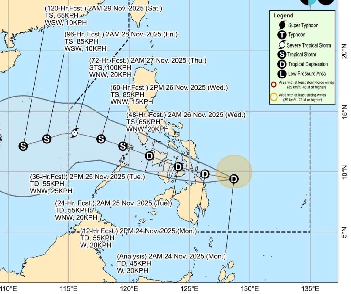
The latest storm information from the Philippine Atmospheric, Geophysical and Astronomical Services Administration said that at 4:00 a.m. on November 24, the center of tropical depression Verbena was at 9.5 degrees north latitude, 128.5 degrees east longitude, 330 km east of Surigao City, Surigao del Norte.
Maximum wind speed 45 km/h, gusts of 55 km/h, central pressure 1002 hPa, moving west at a speed of 30 km/h. The wind radius is 200km from the center of the tropical depression.
The tropical depression is likely to strengthen into a storm in the next 24-48 hours.
The special thing that prompted PAGASA to warn early is that this storm is not forecast to have too strong winds, but "causes deadly rain" with huge rainfall that could sink many localities.
Initial forecasts show the system will make landfall in the Caraga area tonight, then cross the Visayas, overflow to MIMAROPA and then move out into the East Sea on Wednesday morning (November 26), becoming the 15th storm. This is a route through areas that are in a state of saturated land, rising rivers and streams and not recovering from previous storms.
PAGASA warned that moderate to heavy rains will soon appear in Eastern Visayas, Central Visayas, Siquijor, Caraga and Northern Mindanao from today.
While the large amount of water from Typhoon No. 13 and Typhoon No. 14 is still deeply seeping into the soil, Typhoon Verbena only needs to pour a relatively large amount of rain to trigger flash floods in large river basins, prolonged deep flooding in urban lowlands, and large-scale landslides in mountainous areas, especially in areas that were once dug by Typhoon No. 13.
According to PAGASA's forecast, the potential storm will head towards the South Central Coast of Vietnam.
In the context of the cold air continuously strengthening to the south, the possibility of the upcoming storm will only strengthen at sea. The storm is not forecast to be strong enough to cause strong winds that could threaten the South Central region, however, floods are still a matter of special concern.
Forecast of the cold air mass in the next 24 to 48 hours of the Vietnam National Center for Hydro-Meteorological Forecasting:
Around the afternoon and night of November 24, cold air will affect the Northeast and North Central regions, then affect the Northwest and Central Central regions.
Strong northeast wind level 3-4, coastal areas level 4-5.
In the Northern and North Central regions, there will be no rain, from November 25, the weather will be cold, and there will be some places in the high mountains of the North that will be very cold. The lowest temperature in this cold air mass in the Northern and North Central regions will generally be from 12-15 degrees Celsius, in high mountainous areas, some places will be below 10 degrees Celsius.
Weather forecast for Hanoi: No rain, cold from November 25. The lowest temperature in this cold air mass is generally 13-15 degrees Celsius.


