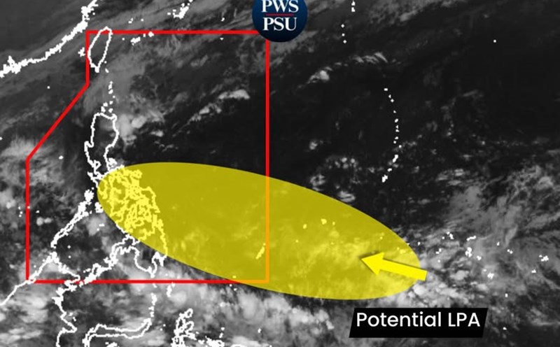
The latest storm information from the Philippine Atmospheric, Geophysical and Astronomical Services Administration (PAGASA) said that at 2:00 a.m. on November 23, a low pressure formed near the boundary of the Philippine Forecast Area (PAR), coordinated at 6.0 degrees north latitude, 136.0 degrees east longitude, about 1,205km east of South Mindanao. The low pressure is likely to strengthen into a tropical depression in the next 24 hours.
If it strengthens into a storm, the system will be locally named Hurricane Verbena.
PAGASA forecasts that the potential storm is likely to impact northeastern Mindanao, Eastern Visayas, especially the provinces of Samar, Northern Samar and Leyte - where typhoon No. 13 Kalmaegi (local name: Tino) has caused heavy rain, deep flooding and strong winds.

The earliest impact time may be from the afternoon of November 23, with the intensity of rain increasing sharply from November 24 onwards, lasting for many days.
PAGASA forecasts that the potential storm could move similar to Typhoon No. 13, moving westward, sweeping across Mindanao - Samar - Leyte, then entering the South China Sea, becoming the 15th storm of the week from November 28 to December 4.
ECMWF, GFS, ICON and Google DeepMind all predict the system will move rapidly westward.

In the early stages, the main threat is not typhoon winds but extremely heavy rain, as the system will interact with wind shear and the northeast monsoon - which is causing heavy rain in Cagayan, Isabela and northeastern Luzon.
PAGASA warned that flooding, flash floods and landslides are the biggest threat, especially in Samar - Leyte - Northern Mindanao, where land has saturated with water after storm No. 13.
Current forecast models show that if the storm No. 15 keeps moving west or west-northwest, it will likely affect Central Vietnam, or further south of the South Central region.
The Vietnam National Center for Hydro-Meteorological Forecasting also said that from now until December 20, there is a possibility of 1-2 storms or tropical depressions appearing in the East Sea area, which may affect the mainland of Vietnam.
Also during this period, in the provinces/cities from southern Quang Tri to Da Nang, the east of Quang Ngai province to Dak Lak and Khanh Hoa, widespread heavy rains may appear concentrated in late November and early December.
Regarding rain forecast, last night and early this morning (November 23), in Hue City, Da Nang City and the east of the provinces from Quang Ngai to Dak Lak, Khanh Hoa and the Southwest region, there was rain, showers and thunderstorms in some places.
Forecast of rain from early morning of November 23 to early morning of November 25: Hue City, Da Nang City and the eastern part of Quang Ngai province will have moderate rain, heavy rain with common rainfall of 60-120mm, locally over 250mm.
Day and night of November 23: The eastern provinces from Gia Lai to Dak Lak, Khanh Hoa, Lam Dong and the South will have scattered showers and thunderstorms; common rainfall is 10-30mm, locally over 70mm. Warning of the risk of heavy rain (>60mm/3 hours).