The double typhoon is forecast to enter the US next week, right when 82 million people flock to airports and highways on Thanksgiving Day, while cold air and extreme cyclones are opening up the most severe weather scenario in early winter.
The FOX Forecast Center's hurricane forecast says the first storm will bring heavy rain to Texas and the southeast region, starting on the evening of November 23 and lasting through Tuesday (November 25. This is a dangerous rainstorm just days after central Texas suffered widespread flash flooding.
Heavy rains will cover Dallas, Austin and many key traffic routes on Monday morning (November 24), with the possibility of flash flooding in central - northern Texas, Oklahoma and Arkansas. Local rainfall could reach 75-125 mm in 48 hours.
By Tuesday (November 25), thunderstorms will move into the Tennessee Valley and throughout the southeastern United States.
On Wednesday (26) as millions of people began pouring into major airports, a strong cold front could see snowfall in Minneapolis.
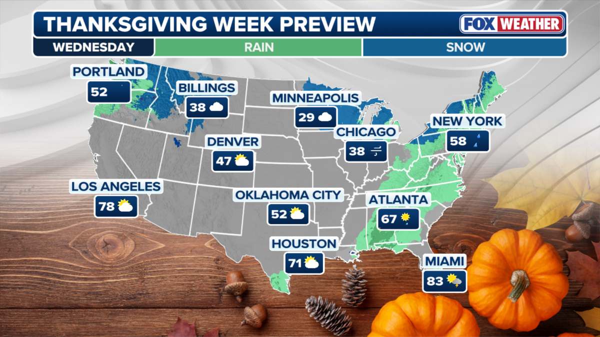
Thanksgiving (Thursday, November 27) is expected to be drier in much of the United States. However, forecast models are still not consistent on the possibility of snow or snowfall in the northeast.
Long-term models show that disturbances in the circulation layer can cause extremely weak cyclones, creating conditions for cold air to flow down to northern states and slide deep into the central and eastern United States.
Meanwhile, in Vietnam, the National Center for Hydro-Meteorological Forecasting also warned about the strengthening of cold air. Around the afternoon and night of November 24, cold air will affect the Northeast and North Central regions, then affect the Northwest and Central Central regions.
In the Northern and North Central regions from November 25, it will be cold, with some mountainous areas in the North experiencing severe cold. The lowest temperature in this cold air mass in the Northern and North Central regions will generally be from 12-15 degrees Celsius, in high mountainous areas, some places will be below 10 degrees Celsius.
Hanoi weather forecast: From November 25, it will be cold. The lowest temperature in this cold air mass is generally 13-15 degrees Celsius.
At sea, from the afternoon of November 24, in the Gulf of Tonkin, the northeast wind will gradually increase to level 6, gusting to level 7-8, rough seas, waves 2.0-4.0m high.
In the northern East Sea, the northeast wind will gradually increase to level 7, gusting to level 8-9, rough seas, waves 4.0-6.0m high.
From the evening of November 24, the area from southern Quang Tri to Ca Mau, the central East Sea area will have northeast winds gradually increasing to level 6, sometimes level 7, gusting to level 8-9, rough seas, waves from 3.0-5.0m high.
On the night of November 24 and November 25, the lowest temperature in the North was 14-17 degrees Celsius, in mountainous areas 11-14 degrees Celsius, in high mountainous areas below 10 degrees Celsius; the average temperature was 17-19 degrees Celsius, in mountainous areas 14-16 degrees Celsius, in high mountainous areas below 13 degrees Celsius.
The lowest temperature in the North Central region is 15-18 degrees Celsius; the average temperature is 18-20 degrees Celsius.
Warning of the possibility of natural disasters accompanying: Hue City, Da Nang City and the eastern part of Quang Ngai province will have widespread heavy rain.
In addition, potential storm No. 15 is likely to enter the East Sea on the morning of November 26, forecast to move westward to the South Central Coast of Vietnam.


