The appearance of a very strong El Nino can significantly change the way storms move in this year's storm season, especially in the Atlantic region.
According to Mr. Paul Roundy, an atmospheric scientist at the University of Albany (USA), there are signs that "the real potential of a El Nino year is the strongest in 140 years" in 2026.
Mr. Roundy cited that in the past week, two tropical storms including storm Maila and storm Sinlaku appeared on both sides of the equator in the western Pacific region. This phenomenon created strong west winds, pushing warm water masses to move east - one of the important conditions promoting El Nino development.
The appearance of the above-mentioned double storm pair, combined with strong west winds lasting from the beginning of the year, is significantly increasing the possibility of El Nino forming rapidly.
According to analysis based on data from 1966 to now, El Nino tends to reduce the number of storms and tropical depressions forming in the Atlantic. However, more notably, it also directly affects the path of the storm, a decisive factor in which area will be affected.
In years with strong El Nino, most storms formed in the central and eastern Atlantic usually do not go straight into the US mainland. Instead, they move in a curved orbit - going west and then circling north and northeast, away from the coast.
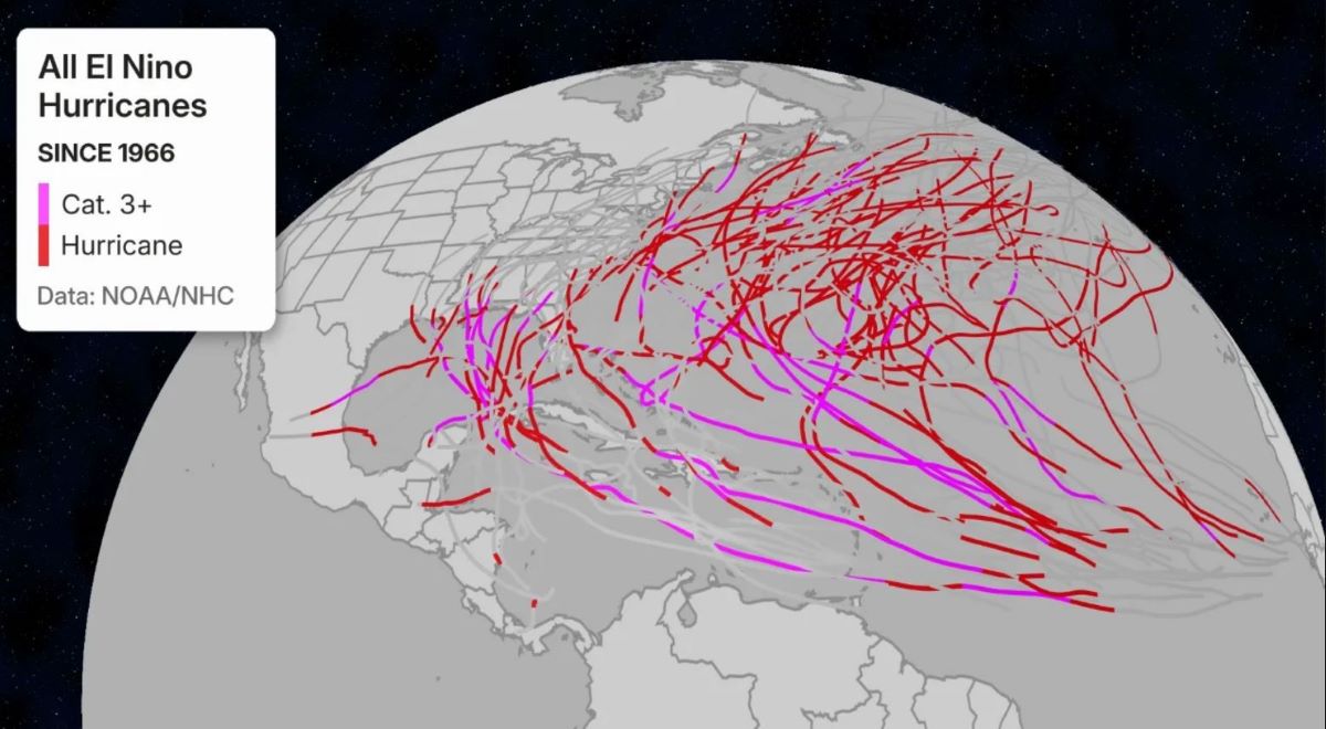
The main reason lies in the weakening of the Bermuda high pressure - an atmosphere system that acts as a "steering wheel" to guide storms. When El Nino appears, this high pressure area weakens, making storms more likely to be "driven" further away from the mainland.
This is why in strong El Nino seasons, very few storms directly hit the US East Coast with high intensity.
Another notable point is that the Caribbean region usually records fewer storms in strong El Nino years. Even in some "super strong" El Nino seasons, no storms form or maintain intensity here.
The reason is the increase in high-altitude westerly winds and strong wind cuts - factors that disrupt storm development. These conditions make the environment harsh for tropical systems.
Although the number of storms may decrease, experts warn that El Nino does not mean a safe storm season. Reality shows that just one strong storm is enough to cause serious damage.
For example, during the strong El Nino season of 2015, Hurricane Joaquin reached level 4 and caused heavy damage in the Bahamas. Or before that, Hurricane Agnes in 1972, although not too strong when it made landfall, caused serious flooding in the northeastern United States, killing more than 100 people.
This shows that the impact of the storm depends not only on the number or intensity, but also on the trajectory and time of landfall.
Scientists emphasize that although historical data provides many suggestions, each storm season has its own characteristics. A strong El Nino can change the "risk map", but does not completely eliminate the risk.
Even when an El Nino is considered the strongest in hundreds of years to appear, the basic rule remains unchanged: Just one storm can shape the entire disaster season.


