Meteorologists issued warnings about the possibility of El Nino returning this year with particularly strong intensity, which could even become one of the most serious events in history, if current forecasts become reality. Initial signals indicate that this phenomenon seems to have begun to form.
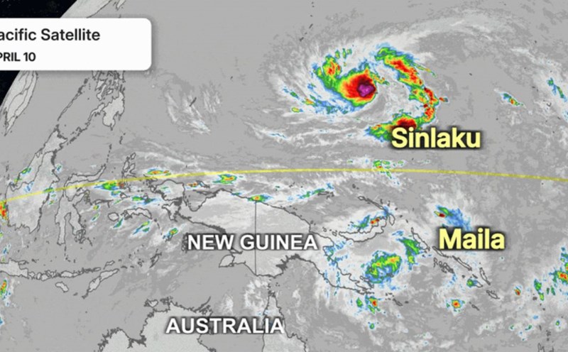
In the past week, two tropical storms including storm Maila and storm Sinlaku appeared on both sides of the equator in the western Pacific region. This phenomenon created strong west winds, pushing warm water masses to move east - one of the important conditions promoting El Nino development.
According to Mr. Paul Roundy, an atmospheric scientist at the University of Albany (USA), this may be a sign of "the real potential of the strongest El Nino year in 140 years".
The appearance of the aforementioned double storm pair, combined with strong west winds lasting from the beginning of the year, is significantly increasing the possibility of El Nino forming rapidly. Unusual warm water currents continue to spread after La Nina ends, creating a favorable foundation for a new climate cycle.
Mr. Roundy predicted that El Nino could develop in just 1 to 2 months. Previously, a leading climate forecasting model also estimated that there is about 62% chance that a strong El Nino will form this summer.
In the past two decades, El Nino has almost become a "keyword" associated with extreme weather. This phenomenon occurs when the usual rules of temperature, ocean currents and atmosphere in the Pacific Ocean are disrupted, often repeated in cycles of 2 to 7 years. At that time, winds change, dragging large amounts of moisture to the east, increasing storms in many areas.
This return is even called "super El Nino" or "El Nino Godzilla" by some experts, implying that the level of devastation could be very large. For California (USA), the worst-case scenario may include severe winter storms, widespread flooding and severe coastal erosion in the 2026-2027 season.
Usually, the impact of El Nino in California is most evident in winter, with heavy rain, heavy snow and high tides. However, in the context of climate change, this phenomenon this year may also contribute to pushing global heat and temperatures to new record levels.
However, experts also warn against expecting El Nino to solve the prolonged drought in the US Southwest. According to data from Drought.gov, this area has experienced nearly 6 consecutive years of drought, and needs more than 1 year of heavy rain to restore water sources at reservoirs, rivers, streams and aquifers.
Mr. Philip Gonsalves, a meteorologist at the US National Weather Service in San Diego, noted that although the signs are clearer, El Nino does not always develop as predicted.
There are many factors that govern seasonal rainfall, so it is not certain that a strong El Nino scenario will occur," he said.