According to the Philippine Atmospheric, Geophysical and Astronomical Services Administration (PAGASA), at 4 am on February 4, the center of the tropical depression Basyang was located about 895km northeast of Mindanao Island, at 9.1 degrees north latitude and 133.6 degrees east longitude.
Basyang currently has the strongest wind near the center reaching 55 km/h, gusts up to 70 km/h, central pressure about 1,002 hPa.
This system is moving in a west-southwest direction at a speed of about 20 km/h. Strong winds related to the tropical depression have spread to a radius of about 210km from the center, showing a fairly large range of influence, especially at sea.
PAGASA has issued Tropical Cyclone No. 1 signals for some southern areas of Surigao del Sur province on Mindanao Island, with common wind speeds from 39-61 km/h.
In addition to strong winds, heavy rain is another notable risk. PAGASA said heavy rain could occur in many areas affected by Basyang, especially coastal and mountainous areas, where winds may be stronger than general forecasts. PAGASA warns of the risk of flash floods and landslides in vulnerable areas.
Besides the direct impact from the tropical depression, the strengthening northeast monsoon will also cause strong winds to gusts of typhoon winds in many places on the Philippines in the coming days.
At sea, strong wind warnings have been issued for the east coast of the Visayas region. Sea waves are forecast to be very high, in some places up to 4-4.5 m high in the sea areas east of Northern Samar, Eastern Samar, Dinagat Islands, Siargao and Surigao del Sur.
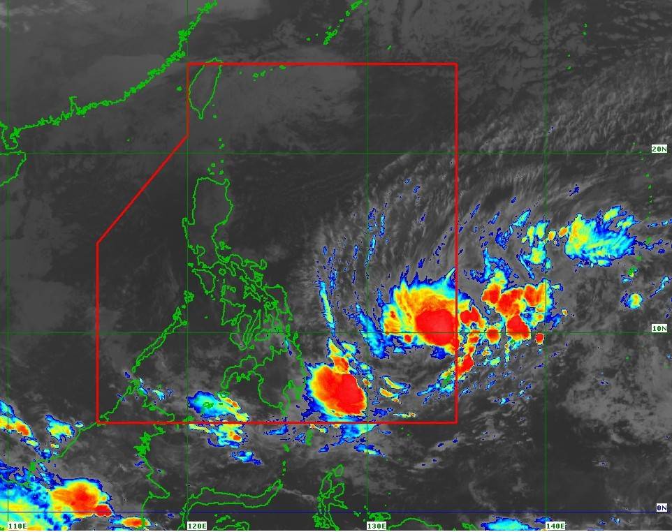
Regarding the next developments, PAGASA predicts Basyang will continue to move west-southwest until the end of tomorrow (February 5), before turning west-northwest from Friday morning (February 6).
The tropical depression is likely to make its first landfall in the eastern region of Mindanao from the evening of February 5 to the morning of February 6, then pass through the northeast of Mindanao, the central and western Visayas, and then move out to the Sulu Sea on the morning of February 7. By the afternoon of the same day, this system could cross the north of Palawan Island and enter the East Sea.
Notably, during its movement in the Philippine waters, Basyang is forecast to gradually strengthen and may reach typhoon level today. After making landfall, this system will weaken back into a tropical depression and is likely to dissipate into a low pressure area early next week.
Regarding the East Sea weather forecast, the Vietnam National Center for Hydro-Meteorological Forecasting said that on February 4, the northeastern sea area of the northern East Sea will have level 6 northeast wind, gusting to level 7-8; waves 3.0-5.0m high; rough seas.
The sea area from Khanh Hoa to Ca Mau and the sea area west of the southern East Sea (including the western Truong Sa special zone) have level 6 northeast wind, gusts of level 7-8; waves 2.0-4.0m high; rough seas.
About Hanoi weather day and night February 4: Lowest temperature 17-19 degrees C. Highest temperature 22-24 degrees C. Cloudy, light rain in some places, early morning fog and light fog scattered, sunny skies in the afternoon. Light wind. Cold weather in the morning and night.


