Some typhoon forecast models even warn of the possibility of cyclone systems accelerating from December 3-16.
Recent observations by the US National Oceanic and Atmospheric Administration (NOAA) on the tropical convection show that the Madden-Julian (MJO) fluctuations are becoming active again, with a dense convective cloud area over the West Pacific.
Changes in intensity show that MJO is being dominated by the La Nina phenomenon - a climate state that makes it difficult for winds and clouds to cross the central Pacific.
Wind analysis shows two important signals moving at the same time: A weak westerly wind area but extending from the Indian Ocean to the West Pacific, and a faster-moving signal, most likely the Kelvin waves surrounding the world.
When these two signals ets, the westerly winds will explode strongly, creating conditions for unstable weather areas.
Forecast models agree that from late November to early December, the combination could disrupt La Nina trading winds in the central Pacific. That means the MJO could strengthen rapidly in early December.
Regarding tropical cyclones, three new storms and depressions formed in late November. Storm No. 15 (storm Koto) is moving in the East Sea near Vietnam. Tropical Depression 04B has just formed near Sumatra (Indonesia) but is expected to weaken after a few days. Meanwhile, fina - which formed on November 18 - made landfall in northern Australia.
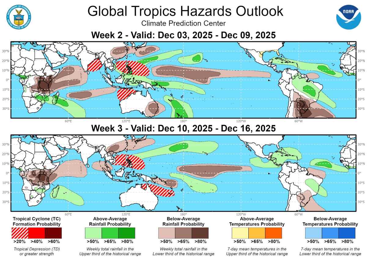
During the week of December 3-9, models warn of the possibility of strong typhoon formation in the areas of Sri Lanka and the western Bay of Bengal. A 20% risk zone has been set for the possibility of a new disruption developing late or regrouping from 04B.
The next week, from December 10-16, the risk of a new cyclone in the Timor Sea or northern part of Western Australia will also be noted, although the signal is still weak.
Strong MJO activity also increases the risk of typhoon formation in the Northwest Pacific, especially near the Philippines - where one or two more cyclones may be seen in early December.
The storm/low pressure information on November 26 from the Philippine Atmospheric, Geophysical and Astronomical Services Administration said that a new low pressure/low pressure is expected to form and enter the Philippine Forecast Area (PAR) in the first week of December and may move closer to Luzon, specifically in the Bicol region.
Regarding rain forecasts, La Nina and MJO interact, causing unpredictable weather fluctuations. The equatorial Central and East Pacific regions continue to lack rain, while heavy rain will continue in the South Pacific and part of the North Pacific, extending to the Hawaiian region.
In West and Central Africa, as well as from southern Brazil to northern Argentina, droughts may become worrying. In contrast, the Caribbean and northern South America are expected to see more than normal rain.
Southeast Asia - which has experienced high rainfall during the La Nina period - is likely to temporarily cool down during this forecast period, before strong atmospheric signals return at the end of the month.


