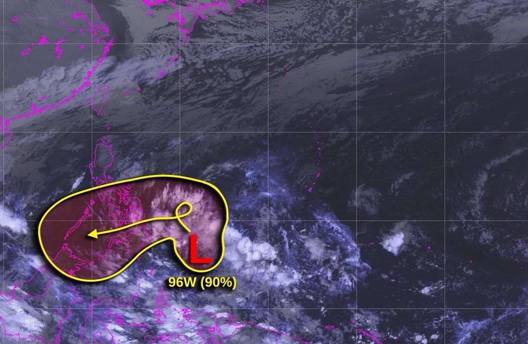
The Philippine Atmospheric, Geophysical and Astronomical Services Administration (PAGASA) said that at 8:00 a.m. (local time) on December 16, a cloud cluster in eastern Mindanao developed into a low pressure area. PAGASA forecast that the possibility of this low pressure area strengthening into a tropical depression within the next 24 hours is low.
Meanwhile, the US Joint Typhoon Warning Center (JTWC) named this low pressure system east of Mindanao (between Palau and Mindanao) as 96W.
The low pressure area will bring widespread showers. Upper-level winds are expected to favor further development, and the JTWC forecasts the low pressure area to intensify into a tropical depression or tropical storm on December 17 or 18 over Mindanao. The system will then move west-southwest over Mindanao over the weekend.
JTWC advised Mindanao, Central and Eastern Visayas to closely monitor the progress of the depression, as conditions may be favorable for rapid organization and intensification over the weekend.
The US Joint Typhoon Warning Center assessed the possibility of a low pressure forming and strengthening within 7 days at 90%.

Meanwhile, according to the weather forecast on December 16 of the Vietnam National Center for Hydro-Meteorological Forecasting, on the day and night of December 16, the southern East Sea (including the Truong Sa archipelago), the sea from Binh Dinh to Ca Mau, from Ca Mau to Kien Giang will have scattered showers and thunderstorms. During the thunderstorms, there is a possibility of tornadoes and strong gusts of wind of level 7-8.
Day and night of December 17, the sea area from Binh Dinh to Ca Mau, the northern area of the North East Sea (including the Hoang Sa archipelago) has northeast wind level 6, sometimes level 7, gusting to level 8-9. The sea is rough; waves are 3-5m high.
The western sea area of the southern East Sea (including the western part of Truong Sa archipelago) has northeast wind level 6, gusting to level 7-8. Rough sea; waves 3-5m high.
Level 2 risk of natural disasters due to strong winds at sea.


