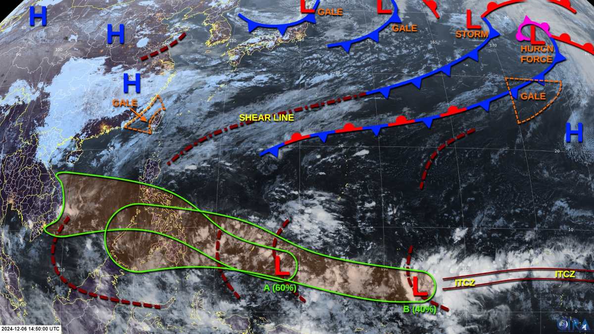
The storm/low pressure forecast bulletin of the US Joint Typhoon Warning Center (JTWC) on December 8 said that low pressure 95W has left the Western Pacific basin and is now low pressure 90B in the Bay of Bengal, affecting areas of India.
Meanwhile, Depression A, a large low pressure area located southeast of the Republic of Palau, continues to produce widespread showers and thunderstorms. Although upper-level winds are favorable for development, the system has not become better organized over the past 24 hours.
However, the system is likely to gradually develop over the next few days, possibly strengthening into a tropical depression early next week after passing over the Philippines and entering the South China Sea.
JTWC advised relevant agencies in Vietnam to monitor the progress of this system. JTWC forecasts a 60% chance of the low pressure intensifying in the next 7 days.
The JTWC weather forecast also noted that although the low pressure is unlikely to strengthen into a typhoon before reaching the Philippines, it could produce areas of heavy rain across the country from December 8-9.
The Philippine Atmospheric, Geophysical and Astronomical Services Administration forecasts that on December 8, the intertropical convergence zone will affect Mindanao. The shear line will affect the eastern parts of Northern and Central Luzon. The northeast monsoon will affect the rest of Northern Luzon.
On the same day, December 8, the JTWC also warned of another low pressure system - Low Pressure B located southeast of Chuuk State in the Federated States of Micronesia. Upper-level winds appear to be favorable for development and this system may become a tropical depression on December 9 or 10.

Upper-level winds are expected to intensify as the system approaches the Philippines on December 11, potentially bringing another round of heavy rains to much of the Philippines from December 11 to 13. The JTWC assesses the chance of the low pressure system intensifying over the next seven days at 40 percent.
For Vietnam, the National Center for Hydro-Meteorological Forecasting said that early on December 8, cold air affected the Northwest, North Central and some places in the Central Central regions; in the Gulf of Tonkin, there were strong northeast winds of level 6, sometimes level 7, gusting to level 8.
In the Northern and North Central regions, the weather is cold. The lowest temperature in this cold air mass in the Northern and North Central regions is generally from 15-18 degrees, in mountainous areas 12-14 degrees, in high mountainous areas, some places are below 10 degrees.
Hanoi area is cold. The lowest temperature in this cold air mass is commonly 15-18 degrees.
At sea: in the Gulf of Tonkin, there is strong northeast wind level 6, sometimes level 7, gusting to level 8, rough sea, waves 2-3m high.
In the North East Sea area (including Hoang Sa archipelago), there are strong northeast winds of level 6-7, gusting to level 8-9; rough seas; waves 4-6m high.
In the sea area from Quang Tri to Quang Ngai, Ba Ria-Vung Tau to Ca Mau, the area between the East Sea and the sea area west of the South East Sea area (including the sea area west of Truong Sa archipelago), the northeast wind gradually increases to level 6, gusting to level 7-8, rough sea; waves 3-5m high.
In the area from Binh Dinh to Binh Thuan, the northeast wind will gradually increase to level 6, sometimes level 7, gusting to level 8-9; rough seas; waves 3-5m high.


