The latest hurricane information from the US National Hurricane Center (NHC) said that Hurricane Erin has maintained a stable intensity over the past few hours. The storm is still a Category 2 hurricane, with sustained winds of 177 km/h.
The storm is moving north at a speed of 22 km/h and is about 480 km south-southeast of Cape Hatteras, North Carolina, USA.
Heavy rain and stronger winds from Hurricane Erin are being recorded in an area about 80km from the North Carolina coast, but the outer rain bands of the latest storm of the Atlantic hurricane season are leading to thin rain and thunderstorms in the eastern part of the state.
US hurricane forecasters warn that the sea situation will continue to deteriorate in the coming hours, as the wind begins to strengthen significantly.
Erin is forecast to strengthen again into a Category 3 hurricane on the morning of August 21.
Erin is currently a Category 2 storm, but has been on a rather long journey for over a week. On the afternoon of August 16, Erin was a Category 1 hurricane with winds of 120 km/h. Just 24 hours later, the storm rapidly intensified to Category 5, with sustained winds of 260 km/h.
This development puts Erin on the list of the fastest-strengthening storms in the Atlantic and is likely to be the fastest-strengthening storm to activity before September 1.
Storms classified as rapidly strengthening Typhoons typically have winds of over 56 km/h for at least 24 hours. Such a rapid strengthening of the storm usually only happens in September and October.
However, this phenomenon has been recorded more often in recent typhoon seasons due to climate change.
Seeing such an early formation of a Category 5 hurricane, especially outside the Gulf of Mexico, is also unusual, as the strongest storms typically appear during the second half of the hurricane season.
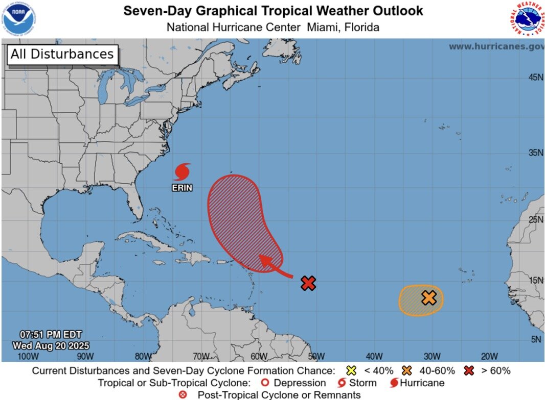
The accelerating Atlantic hurricane season typically begins in mid-August. Meteorological experts at the US National Hurricane Center are monitoring two low pressure areas that could develop into tropical depressions in the same area that Erin passed through last week.
The low pressure is likely to strengthen into a next storm, Erin, located in the tropical Atlantic Ocean. Initial signs suggest the system could move north similar to Typhoon Erin.
According to the latest hurricane forecast from the US National Hurricane Center, right after Erin, there is a high chance, up to 70%, of a new storm forming in the next 7 days from this low pressure area.
Initial signs show that the new storm's projected path is similar to Erin, but will curve north earlier than Erin. The new storm is not expected to pose a threat to the United States but will put Bermuda in a dangerous position.
Another low pressure near the Cabo Verde Islands in Africa has a moderate chance of developing into a short-term tropical depression before encountering more severe atmospheric conditions over the weekend.
The next storms for the Atlantic hurricane season are Fernand and Gabrielle, respectively.


