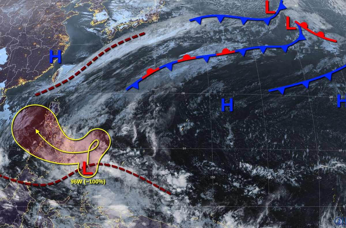
According to the Philippine Atmospheric, Geophysical and Astronomical Services Administration, at 3:00 a.m. on December 17, local time, the center of low pressure (12a) was located at about 6.8 degrees north latitude, 127.1 degrees east longitude, 155 km southeast of Tagum City, Davao del Norte. The low pressure is likely to strengthen into a tropical depression in the next 24 hours.
Due to the low pressure located along the Intertropical Convergence Zone, it affects Visayas and Mindanao. Eastern Visayas, Caraga and Davao region will have cloudy skies, scattered thunderstorms, and a risk of flash floods or landslides due to the influence of the low pressure.
Meanwhile, Bicol and Quezon regions were affected by thunderstorms due to wind shear. Cagayan Valley, Cordillera Aurora administrative region was affected by the northeast monsoon, warning of flash floods or landslides due to heavy rains. Metro Manila and the rest of Luzon received light rains due to the northeast monsoon.
The US Joint Typhoon Warning Center (JTWC) named the low pressure area east of Mindanao (Philippines) as Invest 96W, warning that this low pressure area will continue to bring showers.
Scatterometer data shows the circulation of the depression has become more defined, although it is still quite wide and elongated. The depression is generating winds of 20 to 25 knots and has the potential to strengthen into a typhoon, according to the JTWC forecast.
The low pressure area is forecast to move north and then northeast before curving east-northeast of Mindanao over the next few days. Winds and upper-level moisture are favorable for further development, with the low likely to intensify into a tropical depression or typhoon in the next 1-2 days.

The system will turn west-southwest over the weekend and move inland over northern Mindanao on December 20 or 21, as upper-level winds begin to increase.
JTWC advised Mindanao, Central and Eastern Visayas of the Philippines to continue monitoring the progress of this low pressure, as the chance of the low pressure intensifying within 7 days is nearly 100%.
Meanwhile, the weather forecast of the Vietnam National Center for Hydro-Meteorological Forecasting said that on the day and night of December 17, the southern East Sea (including the Truong Sa archipelago), the sea area from Binh Thuan to Ca Mau will have scattered showers and thunderstorms. During the thunderstorms, there is a possibility of tornadoes and strong gusts of wind of level 7-8.
Day and night of December 18: The northern East Sea area (including the Hoang Sa archipelago) has strong northeast winds of level 6-7, gusting to level 8-9. Rough seas; waves 3-5m high.
The central East Sea has strong northeast winds of level 6, sometimes level 7, gusting to level 8-9. Rough seas; waves 3-5m high.
The sea area from Quang Tri to Ca Mau, the sea area west of the southern East Sea (including the sea area west of Truong Sa archipelago) has northeast wind level 6, gusting to level 7-8. Rough sea; waves 3-5m high, especially the sea area from Quang Tri to Quang Ngai has waves 2-4m high.
Gulf of Tonkin has strong northeast winds of force 5, sometimes force 6, gusting to force 7-8. Rough seas; waves 1-2.5m high.
Disaster risk level due to strong winds at sea: level 2.


