The latest storm and low pressure information from the Philippine Atmospheric, Geophysical and Astronomical Services Administration (PAGASA) said that at 2:00 p.m. on August 23, low pressure near the East Sea 08f entered the Philippine Forecast Area (PAR).
This low pressure has strengthened and is likely to develop into a tropical depression within the next 24 hours.
In the latest update released at around 4:00 p.m. on August 23, PAGASA forecasters said that the nearest location identified for 08f is 940 km east of Southern Mindanao, Philippines.
"The current low pressure is likely to develop into a tropical depression within the next 24 hours," PAGASA noted.
If this low pressure near the East Sea becomes a tropical depression, it will be locally named Jacinto and the 10th system in 2025 in the Philippines.
Meanwhile, Typhoon No. 5 in the East Sea, Kajiki (known as one one one in the Philippines, one one one in the Philippines) was last located 570km west of Sinait, Ilocos Sur, outside the Philippines' forecast area.
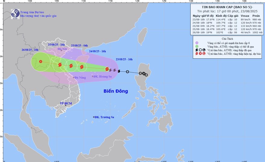
Philippine typhoon forecasters said that Typhoon No. 5 Kajiki is currently having maximum sustained winds of 85 km/h and gusts of 105 km/h. This storm in the East Sea is moving west at a speed of 30 km/h.
The typhoon report from the Hong Kong Meteorological Observatory (China) said that strong winds from the effects of Typhoon Kajiki began affecting offshore areas and high ground in southern Hong Kong (China).
"According to the current forecast, Kajiki will be closest to Hong Kong (China) on the night of August 23, about 500km south of Hong Kong (China) and will continue to strengthen," forecasters noted.
Due to the impact of Kajiki, strong winds will occasionally affect southern Hong Kong (China) and neighboring waters on August 23 and the morning of August 24.
The outer rain bands associated with Typhoon Kajiki - from Japanese meaning sword - are also affecting the sea south of Hong Kong (China) and gradually approaching the coast of Guangdong, China.
The weather forecast agency noted that unless Kajiki rapidly intensifies or turns north, warning signal No. 1 will remain in effect until 9:00 a.m. on August 24 in Hong Kong (China). Showers and thunderstorms are forecast across Hong Kong (China) until August 24.
The latest storm information from the Thai Meteorological Agency on August 23 said that Typhoon No. 5 Kajiki, which is a tropical depression in the East Sea, is moving west at a speed of 30 km/h.
Thai weather forecasters expect the storm to strengthen, making landfall on the coast of Vietnam and northern Laos on August 25 and 26.
The latest storm in the South China Sea is likely to bring heavy to very heavy rains across northern Thailand, northeast, east, southwest, including Bangkok and the suburbs.
People in low-lying areas, near the foot of hills or along waterways are advised to be on guard against flash floods.


