With just a few weeks left until the end of the 2025 Atlantic hurricane season, the National Hurricane Center (NHC) said there was no sign of a tropical storm forming next week.
However, the calmness of the tropics does not mean that the weather will become pleasant, as strong cold air waves are causing a series of other harsh phenomena.
According to the latest warning, North Florida and the northern inland areas of Central Florida are under a freeze warning, with the lowest temperature likely to drop to -1 to -6 degrees Celsius over the night and morning of November 11. The strong cold winds make the actual feeling down to below -7 degrees Celsius.
The strong cold air mass extending from Crystal River (Florida) to Veracruz (Mexico) is rapidly moving southeast, carrying strong north to northeast winds of level 7-8, very rough seas in the Gulf of Mexico.
AccuWeather forecasters say the sea surface temperatures in the Caribbean are still warm enough to support cyclone formation, but the possibility of affecting Florida or the US in general is nearly zero until November 19. If there is a new storm, it will be named Nestor.
The Atlantic hurricane season officially ends on November 30, but according to meteorological statistics, an average of one named storm every two years in November. However, in recent years, late-season typhoons have occurred more frequently due to rising sea temperatures, meteorologist DaSilva said.
According to the NHC, the 2025 typhoon season has had 13 named storms, of which 5 have become major storms, including 4 that have reached Category 3 or higher.
Although there are no new storms, experts warn that strong winds, big waves and sudden cold will be the main risks in the second half of November.

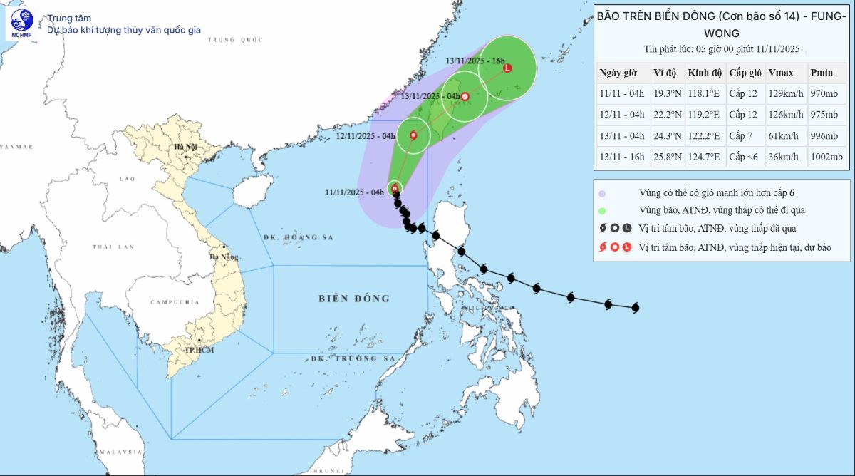
Meanwhile, in the East Sea, according to the latest storm information from the Vietnam National Center for Hydro-Meteorological Forecasting, at 4:00 a.m. on November 11, the center of storm No. 14 was at about 19.3 degrees north latitude; 118.1 degrees east longitude, in the eastern sea area of the northern East Sea. The strongest wind near the storm center is level 12 (118-133 km/h), gusting to level 15. The storm is moving north-northwest at a speed of about 10 km/h.
Regarding cold air, around November 12 - 13, a weak cold air mass will affect the North; then around November 17 - 18, a stronger northeast monsoon will flow in.
The meteorological agency also forecasts that in November 2025, cold air will continue to increase in frequency and intensity. The phenomenon of severe cold in the North is likely to appear from the second half of December, equivalent to the average of many years.
Regarding the weather forecast for the day and night of November 11:
Hanoi City: Lowest temperature 21-23 degrees Celsius; highest 24-26 degrees Celsius. Cloudy, with rain in some places. Northeast wind level 2-3.
Ho Chi Minh City: Lowest temperature 24-26 degrees Celsius; highest 31-33 degrees Celsius. Cloudy, sunny during the day, showers and thunderstorms in some places in the evening and at night. Light wind. During thunderstorms, there is a possibility of tornadoes, lightning and strong gusts of wind.


