The latest climate signals show a major turning point taking place in the Pacific. According to the US National Oceanic and Atmospheric Administration (NOAA), La Nina is clearly weakening and is likely to shift to neutral status within the next month.
More notably, weather and climate forecasting models are agreeing on the possibility of a strong El Nino outbreak, even reaching the "super El Nino" threshold right at the time when the Atlantic hurricane season enters its peak.
With the storm season, El Nino is often seen as a "restraint". This phenomenon creates strong winds up high, making storms difficult to form and develop in the Atlantic Ocean. Conversely, La Nina often makes the storm season more exciting.
However, this year's picture is not simple.
New forecasts from the International Institute for Climate and Social Studies of Columbia University (USA) show that the temperature in the equatorial Pacific region may increase by about 1.5 degrees Celsius compared to the average in October - a characteristic level of strong El Nino. Previously, forecasts only leaned towards a weak El Nino wave.
If this scenario occurs, the number of storms may decrease. Statistics show that in El Nino and Atlantic years, there are an average of about 10 storms and 5 storms reaching major storm level. Meanwhile, La Nina years usually record up to 14 storms and 7 strong storms.
But the decisive factor is not only the wind. The Atlantic water surface temperature is currently still higher than average, creating an abundant "fuel" for storm development. This leads to a "fight" between two factors: Adverse winds due to El Nino and warming oceans driving storms.
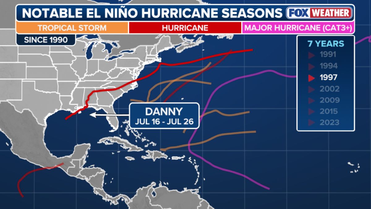
Experts warn that even during a strong El Nino year, the risk of major storms is still zero. History has proven that.
In 1992, Super Typhoon Andrew formed in one year of El Nino, causing damage of more than 25 billion USD and killing 65 people. More recently, in the 2023 hurricane season, Hurricane Idalia caused damage of about 3 billion USD when it made landfall in Florida (USA).
The important thing at this time is the rate of climate transition. If El Nino forms early in the middle of summer, it can curb storm activity during peak times. Conversely, if this process is slow, the window for early season storms can still open.
Similarly, in the East Sea and Northwest Pacific regions, the impact of El Nino, especially super El Nino, also often causes the number of storms to decrease but also poses a risk of strong, unpredictable storms appearing.
Research shows that in El Nino years, the frequency of storms in the East Sea tends to be less than in La Nina years, but the intensity of some storms increases significantly.
At the same time, the storm season also tends to come later and shorter by about 1 month compared to neutral conditions. However, the warming sea temperature factor - which is strongly affected by ENSO - can add energy for storms to develop faster and stronger.
This means that although the number of storms may decrease during the super El Nino year, the risk of extreme storms making landfall in Vietnam and the region is still worrying.


