After many years of dominating global weather, the La Nina phenomenon in the Pacific is weakening and almost completely collapsing. The latest ocean analysis by the European Center for Medium-term Weather Forecasting (ECMWF) shows that sea temperatures in the equatorial Pacific region are rising rapidly, signaling a new El Nino phase is forming and is likely to become very strong in the near future.
This transition is driven by unusually strong west winds and a giant "ocean Kelvin wave" moving from the west to the east of the Pacific Ocean. This is a form of subsurface heat wave, carrying large amounts of warm water at a depth of about 100-250m and can quickly warm the surface water layer.
Monitoring data shows that La Nina peaked around December last year, but since the beginning of this year, cold temperature anomalies have quickly disappeared.
In the eastern Pacific region, seawater temperatures are currently about 2 degrees Celsius above average. This warming trend is spreading throughout the tropics of the ocean, showing that the La Nina period has actually ended.
Long-term weather forecast models of the North American Integrated Weather Forecasting System (NMNE) agree that El Nino will appear in 2026. However, the strength of this phenomenon is still different between models, from weak El Nino to the possibility of reaching the "super El Nino" threshold, i.e., seawater temperatures at least 2 degrees Celsius higher than the average for a long time.
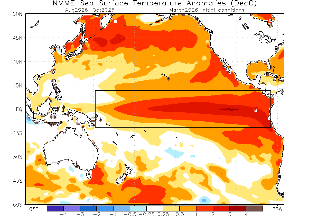
According to many meteorologists, if current heat anomalies continue to increase as predicted, the possibility of forming a super El Nino by the end of 2026 is quite high. Such events have caused major global weather fluctuations, from severe floods to prolonged droughts.
The first impact may appear in the summer of 2026. Meteorological analysis shows that the rapid transition from La Nina to El Nino often changes the atmospheric pressure structure on a global scale. In North America, the eastern United States and eastern Canada may experience low pressure areas, making summer temperatures here tend to be cooler than normal.
In Europe, forecast models also show a trend of normal or lower than average temperatures in the western continent, while Central and Eastern Europe may be warmer.
One of the most obvious impacts of El Nino is the impact on the Atlantic hurricane season. When El Nino appears, wind cuts are stronger and the atmosphere is more stable in the Atlantic, making tropical storms difficult to form and develop. This could help reduce the number of major storms in the 2026 hurricane season.
The impact of El Nino will also be more pronounced in the winter of 2026-2027. During this period, polar rays tend to move northward, making the northern US and Canada warmer than usual, while the southern US may have more rain.
However, experts emphasize that each El Nino has its own characteristics. However, current signs suggest that 2026 may witness a major change in the global climate system as La Nina ends and a strong El Nino is gradually forming under the Pacific Ocean.


