The Joint Typhoon Warning Center (JTWC) said that the recent pre-season climate activity has become chaotic due to many forms of atmospheric fluctuations affecting each other.
However, RMM dynamic forecast shows that the Madden-Julian fluctuation signal (MJO) will return to the traditional trajectory, moving eastward to Phase 2 next week and approaching the area between the Indian Ocean and the Pacific Ocean, mainly in Southeast Asia including Indonesia, Malaysia, the Philippines, Papua New Guinea, Brunei, East Timor, and northern part of Australia in late March.
MJO is a climate phenomenon that affects weather globally, especially rain and tropical storms.
In addition, La Nina is showing signs of weakening as sea surface temperatures in all Nino areas in the equatorial Pacific (the area used to monitor El Nino and La Nina) have increased significantly in the past few weeks.
With the development of MJO, the possibility of tropical storm formation in the southeastern Indian Ocean will increase in the period from 12-25 March 2025.
Last week, a new storm formed, while another is still active after a period of previous storms. On February 25, Typhoon Honde formed in the Mozambique Channel, reaching Category 1 on the Saffir-Simpson scale as it passed south of the peninsula of Madagascar.
Currently, Honde is still active and moving southeast, away from land. The JTWC forecasts that Honde will soon turn into an out-of-tropical cyclone.
Meanwhile, storm Alfred remains strong, currently about 425 km east of Brisbane City (Australia). Previously, storm Alfred had reached Category 3 but has now weakened significantly. JTWC forecasts that Alfred will move west and may make landfall in Brisbane.
Based on the development of MJO, climate models such as GEFS and ECMWF show a high likelihood of tropical cyclones forming in the eastern Indian Ocean in the period from 12-25 March 2025.
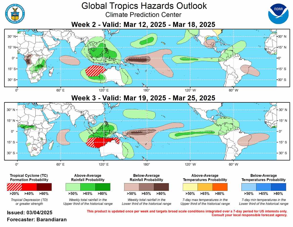
Week from 12-18: The risk of tropical storm formation in northern Australia and the western Indian Ocean increases.
Week from 19-25: Probability of stronger tropical storms in northwestern Australia (40-60%), while the southwestern Indian Ocean has a lower risk (20-40%).
Rainfall forecast based on a combination of ENSO, MJO factors and data from weather forecast models (GEFS, CFS, Canada, ECMWF) shows that with the trend of rising sea surface temperatures in the East Pacific, higher than average rainfall is forecast in the East Pacific and Central America.
In terms of temperature, higher than average temperatures are likely in the Hawaiian Islands, southern and southeastern United States, along with northern Mexico.
Below-average temperatures are forecast for much of the western United States.
In general, the coming period will see notable climate change with the weakening of La Nina, the return of MJO and the increased risk of tropical storms in the Indian Ocean and areas around Australia.