New low pressure seedlings appear, forecast to increase rapidly in the next 24 hours

Châu Anh |

A low pressure area off the Philippines is likely to moderately strengthen into a tropical depression in the next 24 hours.

According to storm and low pressure news from the Philippine Atmospheric, Geophysical and Astronomical Services Administration (PAGASA), low pressure area LPA 09b is being monitored outside the Philippine Area of Responsibility (PAR) and is likely to develop into a tropical depression in the next 24 hours.

According to the bulletin on September 10, the LPA 09b center at 2:00 PM on the same day was located at 14.3 degrees North latitude and 114.9 degrees East longitude, about 590km west of Subic, Zambales province.

PAGASA recommends that people continue to follow updates on the developments of the low pressure area.

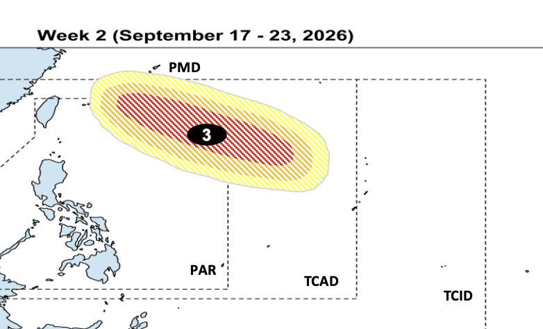
Besides LPA 09b, the forecast shows that 3 weather disturbances may form or enter the Philippine Remote Sensing Area (PMD) in the period from September 10-23.
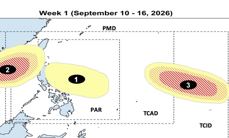
Dự báo số xoáy thuận có khả năng hình thành trong vùng dự báo của Philippines từ ngày 10-23.9. Ảnh: PAGASA
Forecast of the number of monsoons likely to form in the Philippine forecast area from October 10-23. 9. Photo: PAGASA

From September 10-16, all 3 cyclones with characteristics similar to tropical cyclones (TCLV) are forecast to appear in PMD. TCLV1 formed in the Philippine Sea but is only unlikely to develop into a storm. Meanwhile, TCLV2 in the west of PMD and TCLV3 formed between the eastern boundary of the Tropical Cyclone Information Zone (TCID) and the Tropical Cyclone Advisory Zone (TCAD) are both highly likely to develop into a storm.

From September 17-23, TCLV3 is forecast to move to the area between the northeast PAR and TCAD, the possibility of developing into a storm is still high.

PAGASA recommends that people in the Philippines continue to follow updates, as the possibility of tropical cyclone formation is still maintained during the forecast period from September 10-23. 9.

Châu Anh
RELATED NEWS

Typhoon Lowell approaches Hawaii, warning of heavy rain and flash floods

|

Typhoon Lowell is approaching the Hawaiian Islands (USA), with the risk of heavy rain, high waves and flash floods in the coming days.

New low pressure rapidly intensifies into storm, continuously changing direction at sea

|

Depression Pilandok is forecast to strengthen into a storm in the next 12 hours and may head south of Japan.

Forecast of the path of the tropical depression, likely to strengthen into a storm soon

|

Tropical depression Pilandok is moving slowly over the Philippine Sea and may strengthen into a storm in the afternoon of September 1 before leaving the Philippine forecast area.

Successfully rescuing people in the fast-flowing floodwaters in Dak Lak

|

Dak Lak - Functional forces have successfully rescued a resident swept away in the floodwaters.

Case of putting money into radiation therapy books at E Hospital: Director speaks out, commits not to cover up

|

Regarding the reflection that radiation therapy department staff received money, the Director of E Hospital affirmed that he would not cover up or strictly handle any violations.

Typhoon Lowell approaches Hawaii, warning of heavy rain and flash floods

BẠCH DƯƠNG |

Typhoon Lowell is approaching the Hawaiian Islands (USA), with the risk of heavy rain, high waves and flash floods in the coming days.

New low pressure rapidly intensifies into storm, continuously changing direction at sea

Châu Anh |

Depression Pilandok is forecast to strengthen into a storm in the next 12 hours and may head south of Japan.

Forecast of the path of the tropical depression, likely to strengthen into a storm soon

Châu Anh |

Tropical depression Pilandok is moving slowly over the Philippine Sea and may strengthen into a storm in the afternoon of September 1 before leaving the Philippine forecast area.
