
According to storm news, the latest low pressure from the Philippine Atmospheric, Geophysical and Astronomical Services Administration (PAGASA), broadcast at 5 am on August 31 (Philippines time), tropical depression Pilandok is moving almost still in the Philippine Sea, about 1,130km east of the northernmost Luzon.
The center of the low pressure is determined at 20.7 degrees North latitude and 132.8 degrees East longitude. Pilandok maintains maximum winds of 55km/h near the center, gusting up to 70km/h, with a central pressure of 1,000hPa. The strong wind area extends to 450km from the center.
Currently, the Philippines has not issued any wind warning signals to Pilandok. PAGASA assesses that the system is still far from the mainland and is unlikely to make landfall in the Philippines.
Pilandok will tend to move west-northwest - north-northwest, before leaving the Philippine Area of Responsibility (PAR) on the evening of September 2 or early morning of September 3.
In terms of intensity, Pilandok is forecast to maintain its strength in the next 24 hours. Notably, this tropical depression may strengthen into a tropical storm in the afternoon of September 1. Then it is forecast to weaken back into a tropical depression in the morning of September 2 and maintain this intensity for the rest of the forecast period.
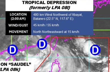
Meanwhile, 2 out of 3 other low pressure areas that PAGASA is monitoring have developed into tropical depressions. Low pressure 08l has strengthened into a tropical depression, while low pressure 08k, formerly known as Obet, has redeveloped into tropical depression Saudel.
The remaining low pressure area, low pressure 08m, currently has the potential to develop into a tropical depression in the next 24 hours.
PAGASA recommends that people continue to monitor weather reports and proactively respond to heavy rain, strong winds, floods and landslides, especially in high-risk areas.


