
According to storm and low pressure news from the Philippine Atmospheric, Geophysical and Astronomical Services Administration (PAGASA) issued on September 7, Typhoon Krovanh (formerly Typhoon Pilandok) has weakened as it moves south of Japan and is forecast to continue to weaken in the coming days.
From September 7-13, 2 ridges with the potential to develop into tropical cyclones (TCLV) are forecast to form inside the Philippine Long-Dash Forecasting Area (PMD).
TCLV1 may form near the eastern boundary of the Philippine Area of Responsibility (PAR), but the possibility of developing into a tropical cyclone is underestimated.
Meanwhile, TCLV2 is expected to appear in the west of PMD and is assessed to have a high probability of developing into a tropical cyclone in the first week.
From September 14-20, TCLV2 is still forecast to exist in the west of PMD and continues to be highly likely to develop into a tropical cyclone.
At the same time, 2 more vortex zones may form in PMD.
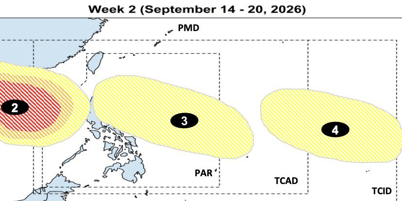
TCLV3 is forecast to appear between the eastern boundary of PAR and the Tropical Cyclone Warning Area (TCAD).
TCLV4 may develop in the east of TCAD and Tropical Cyclone Information Zone (TCID).
However, the possibility of these two systems developing into tropical cyclones is currently underestimated.
Thus, the risk of tropical cyclone occurrence is still maintained throughout the forecasting period. PAGASA said it will continue to monitor changes in the forecasting model and update when necessary.
Climate statistics show that in September, tropical cyclones formed in the east of PAR often move northwest. Some systems tend to change direction to Japan or South Korea.
However, there are also noteworthy scenarios for Vietnam. Some east-forming monsoons of PAR may move northwest, passing through the northern Philippines area before heading south to China or Vietnam. Some other systems may pass through the central and southern Philippines area and then continue to head south to China or Vietnam.


