Storm No. 11 Matmo strengthens rapidly, forecast to become a hurricane when entering the East Sea this afternoon

Khánh Minh |

Typhoon Matmo is forecast to make landfall in the Philippines this morning, then enter the East Sea in the evening, becoming storm No. 11, with a high probability of strengthening into a typhoon.

Typhoon Matmo is forecast to make landfall in Aurora - Isabela (Philippines) on the morning of October 3, then enter the East Sea this evening, becoming storm No. 11, with a high possibility of strengthening into a typhoon.

The latest storm information from the Philippine Atmospheric, Geophysical and Astronomical Services Administration (PAGASA) said that Typhoon Matmo (local name: Paolo) has strengthened overnight and this morning (October 3) as it approached the eastern coast of Luzon Island. At 4:00 a.m. on October 3, the center of the storm was at 16.0 degrees North latitude, 123.5 degrees East longitude, about 150km east of Casiguran Town (Aurora Province).

Maximum winds near the center of the storm are 100 km/h (level 10), gusting to 125 km/h. Central pressure 990 hPa. Strong wind radius: halfway up to 350km from the center of the storm.

The direction is moving West Northwest, speed about 20 km/h.

Anh: Trung tam Canh bao Bao Philippines (PWS/PSU)
Typhoon Matmo is expected to bring heavy rains to Northern and Central Luzon on October 3. Photo: Philippine Typhoon Warning Center (PWS/PSU)

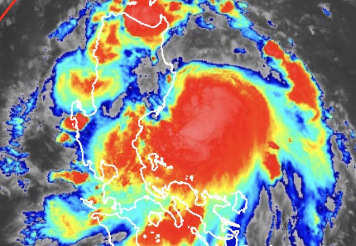
PAGASA warned that Typhoon Matmo will bring heavy to very heavy rains to the northern and central Luzon regions today. There is a high risk of flash floods, landslides in mountainous areas and widespread flooding in low-lying areas.

The storm is forecast to make landfall in the morning or afternoon of October 3 in the northern part of Aurora province or the southern part of Isabela province, then sweep across Luzon Island before reaching the West Philippine Sea (South China Sea) in the evening of the same day.

After passing Luzon, Typhoon Matmo will enter the East Sea, becoming Typhoon No. 11 and is likely to rapidly strengthen into a typhoon (level 12-13). It is expected that by tomorrow morning (October 4), the storm will leave the Philippine Forecast Area (PAR) and move deep into the East Sea, heading northwest.

Meteorological experts say that the intensity of storm No. 11 depends largely on the subtropical high pressure in the North. If the edge of the high pressure moves, the storm's trajectory may change and move lower than initially forecast.

According to the Vietnam National Center for Hydro-Meteorological Forecasting, at 1:00 a.m. on October 4, the center of the storm was at 17.7 degrees North latitude, 118.5 degrees East longitude; in the eastern sea of the North East Sea. Intensity level 10, gust level 12. Moving west-northwest, about 25 km/h, entering the East Sea and likely to strengthen.

Du bao duong di cua bao Matmo. Anh: Trung tam Du bao Khi tuong Thuy van Quoc gia Viet Nam
Forecast of Typhoon Matmo's path. Photo: Vietnam National Center for Hydro-Meteorological Forecasting

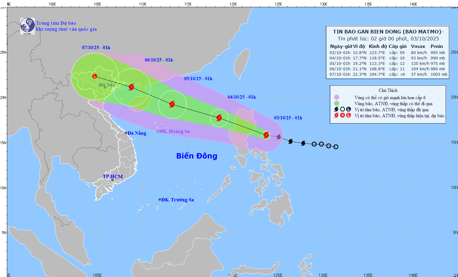
At 1:00 a.m. on October 5, the center of the storm was at 19.2 degrees North latitude, 113.3 degrees East longitude; in the northwest sea of the North East Sea, about 340km East Southeast of the Lusian Peninsula (China). Intensity level 12, gust level 15. Moving west-northwest, 20-25km/h, it is likely to continue to strengthen.

At 1:00 a.m. on October 6, the center of the storm was at 21.1 degrees North latitude, 108.8 degrees East longitude; in the North of the Gulf of Tonkin. Intensity level 11, gust level 14. Moving west-northwest, 20-25 km/h.

Khánh Minh
RELATED NEWS

Storm No. 11 forms, at risk of strengthening when entering the East Sea tomorrow

|

Tropical depression Paolo has strengthened into a storm, becoming storm No. 11 when it enters the East Sea on October 3, with the possibility of causing heavy rain and strong gusts of wind.

Forecast of the first impacts of potential storm No. 11

|

Storm No. 11 is forecast to have the potential to cause heavy rain, strong winds and coastal flooding as it approaches the shore.

The predecessor of storm No. 11 rapidly intensified, with the risk of directly affecting the North

|

The low pressure area considered the predecessor of storm No. 11 in the East Sea has strengthened into a tropical depression today, October 1.

Identifying fake goods and fake news on digital platforms: The key for workers to protect themselves

|

Fake goods and fake news are rampant online, identification skills are a "shield" to help workers protect themselves. To have a panoramic view, Lao Dong Newspaper organized a television talk show: " Identifying fake goods and fake news on digital platforms: The key for workers to protect themselves".

Musician Nguyen Van Chung talks about the song composed and sung by AI that was widely shared

|

Musician Nguyen Van Chung - the father of the song "Continuing the story of peace" reached 6.5 billion views on platforms - speaking about AI singing and composing.

Shrimp pond owner in Thanh Hoa cries because the storm is so severe

|

Thanh Hoa - After storm No. 10, the scene of devastation covered the shrimp ponds along the seawall, many pond owners had to face difficulties and the risk of debt.

An Giang sets a target of becoming a strong marine economic center of the country by 2030

|

An Giang - The common goal by 2030 is to be a fairly developed province of the country; a strong marine economic center of the country.

Checking and temporarily detaining China's inland moon cake warehouse after Lao Dong's reflection

|

Immediately after Lao Dong published a series of articles about moon cakes without documents or invoices, the authorities inspected the warehouse and temporarily detained many products.

Storm No. 11 forms, at risk of strengthening when entering the East Sea tomorrow

Khánh Minh |

Tropical depression Paolo has strengthened into a storm, becoming storm No. 11 when it enters the East Sea on October 3, with the possibility of causing heavy rain and strong gusts of wind.

Forecast of the first impacts of potential storm No. 11

Song Minh |

Storm No. 11 is forecast to have the potential to cause heavy rain, strong winds and coastal flooding as it approaches the shore.

The predecessor of storm No. 11 rapidly intensified, with the risk of directly affecting the North

Song Minh |

The low pressure area considered the predecessor of storm No. 11 in the East Sea has strengthened into a tropical depression today, October 1.